MotoWeatherman
-
Posts
2,282 -
Joined
-
Last visited
Content Type
Profiles
Blogs
Forums
American Weather
Media Demo
Store
Gallery
Everything posted by MotoWeatherman
-

2021-2022 Fall/Winter Mountains Thread
MotoWeatherman replied to BlueRidgeFolklore's topic in Southeastern States
Surprised no one is talking about the incoming snow Friday afternoon through Saturday. 3-6 looks pretty solid above 4000 ft...maybe more. -
2021-2022 Fall/Winter Mountains Thread
MotoWeatherman replied to BlueRidgeFolklore's topic in Southeastern States
31 and light snow here on Beech. Good dusting and windy. -
2021-2022 Fall/Winter Mountains Thread
MotoWeatherman replied to BlueRidgeFolklore's topic in Southeastern States
Down here at the beginning of the Apps in Dahlonega GA. Light snow Temp is 35.0 and falling -
2021-2022 Fall/Winter Mountains Thread
MotoWeatherman replied to BlueRidgeFolklore's topic in Southeastern States
Right at 2 inches here on Beech and still steady snow falling and 10.8. -
2021-2022 Fall/Winter Mountains Thread
MotoWeatherman replied to BlueRidgeFolklore's topic in Southeastern States
Got about an inch here on Beech. Lol -
2021-2022 Fall/Winter Mountains Thread
MotoWeatherman replied to BlueRidgeFolklore's topic in Southeastern States
Snowing pretty good here on Beech and you can see the change to NW flow snow on the radar. Hopefully it can save the day as the front end was just a dusting. -
2021-2022 Fall/Winter Mountains Thread
MotoWeatherman replied to BlueRidgeFolklore's topic in Southeastern States
Flurries here on Beech. Yahoo.... -
2021-2022 Fall/Winter Mountains Thread
MotoWeatherman replied to BlueRidgeFolklore's topic in Southeastern States
Solid coating here at 4650 on Beech. Maybe half inch or so. Too bad the models really shunted the main band of the precip south the past few days our this could have been a decent event. -
2020/2021 Fall/Winter Mountain thread
MotoWeatherman replied to Met1985's topic in Southeastern States
Torch on Beech. 38 and rain. CAD shield worked to perfection. -
2020/2021 Fall/Winter Mountain thread
MotoWeatherman replied to Met1985's topic in Southeastern States
27.1/21.5 here on Beech. 39 and rain in Dahlonega GA -
2020/2021 Fall/Winter Mountain thread
MotoWeatherman replied to Met1985's topic in Southeastern States
Operation torch in effect here on Beech. LOL. Talk about a temp rise since midnight. My spot is not that great for CAD so we shall see how this unfolds over here. HIGH: 35.8°Fat 11:40 AM LOW: 12.9°Fat 12:00 AM -
2020/2021 Fall/Winter Mountain thread
MotoWeatherman replied to Met1985's topic in Southeastern States
A toasty 45 at 4650 on Beech. Lol -
2020/2021 Fall/Winter Mountain thread
MotoWeatherman replied to Met1985's topic in Southeastern States
1.5 here at the other end of the mountains in Dahlonega GA. -
2020/2021 Fall/Winter Mountain thread
MotoWeatherman replied to Met1985's topic in Southeastern States
Pouring snow at the south end of the mountains here in Dahlonega GA.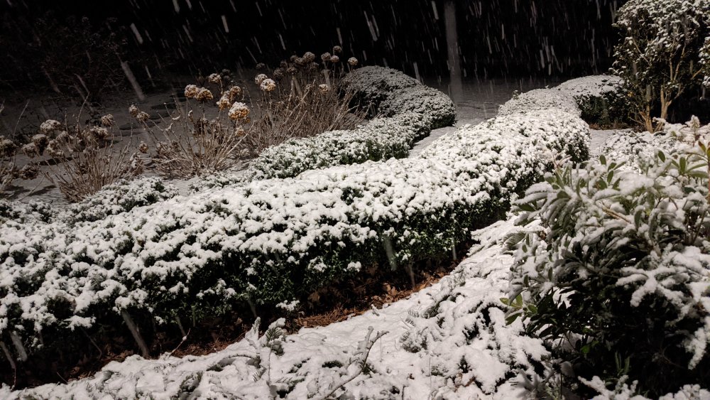
-
2020/2021 Fall/Winter Mountain thread
MotoWeatherman replied to Met1985's topic in Southeastern States
I feel comfortable saying 6-8 inches. At my location the winds really whip and blow the snow so it makes it difficult to find a good spot to get a solid measurement. Lol. Went to bed with about 2-3 so overnight was a big plus. Maybe picked up another inch during the daylight hours. Skied sugar mtn this after and you would never had know it snow up top as it was a solid sheet of ice with 40+mph winds. The lower half of the mountain was decent though. -
2020/2021 Fall/Winter Mountain thread
MotoWeatherman replied to Met1985's topic in Southeastern States
Down to 22.8 with drizzle quality snow going on here on Beech. Somewhere between a 1/2 to 1 inch so far. -
2020/2021 Fall/Winter Mountain thread
MotoWeatherman replied to Met1985's topic in Southeastern States
It's going to be interesting to see how much more you get then me here on Beech as the best will be south of my area. 35.4 here on Beech at 4650 with liquid snow falling. -
2020/2021 Fall/Winter Mountain thread
MotoWeatherman replied to Met1985's topic in Southeastern States
LOL...calm in your snow hole with 40+mph gusts on Beech. Nuts. -
2020/2021 Fall/Winter Mountain thread
MotoWeatherman replied to Met1985's topic in Southeastern States
My location on the side of Beech is prime for east wedge winds. Current Ob is 26.0 with ENE wind at 20. Gust of 44 at 1113pm. -
2020/2021 Fall/Winter Mountain thread
MotoWeatherman replied to Met1985's topic in Southeastern States
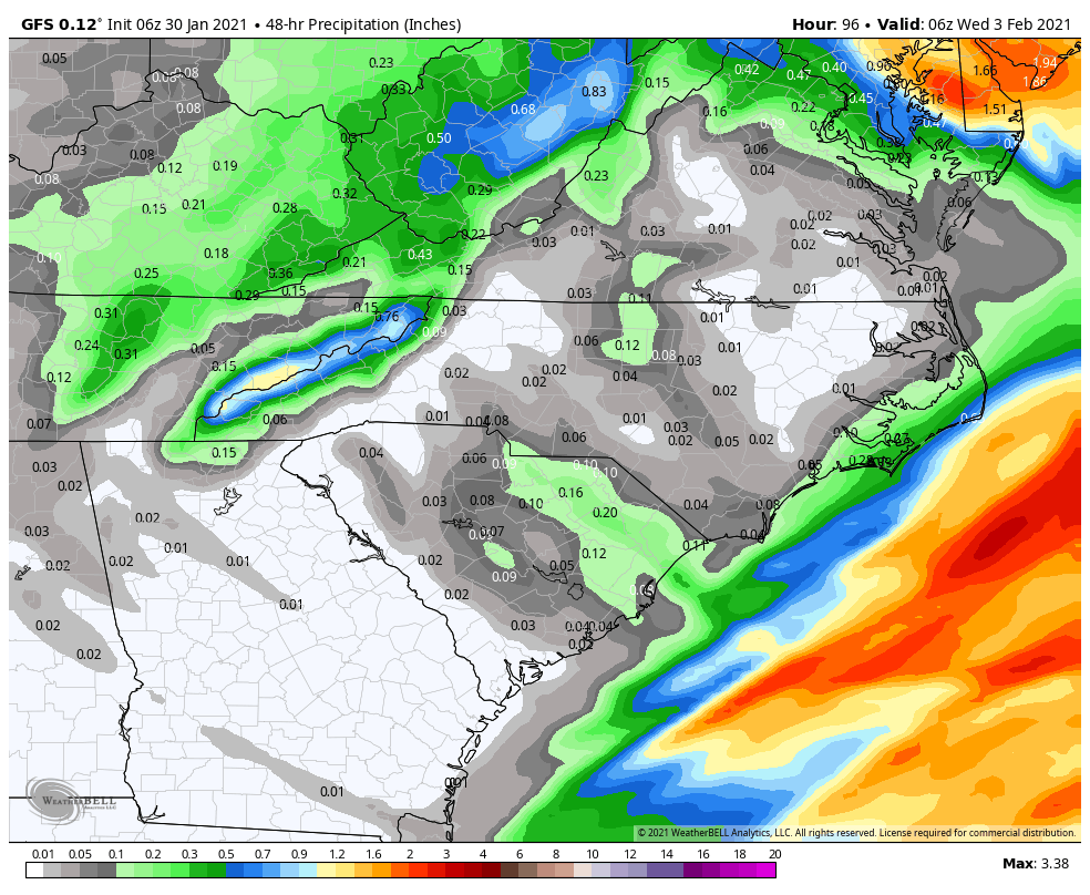
As Met and others have already mentioned, the NW flow snow looks very robust. This is the latest GFS 48 percip starting 6z Monday(1am) ending 6z Wednesday (1am) which should encompass the whole NWFS event. In most of our NWFS events the moisture is confined to 850mb and lower. With this one 700mb (9-10k feet up) moisture is going to be plenty throughout Monday. Then as the 700mb moisture moves out Monday night, the coldest 850mb temps come in with plenty of 850mb moisture around to keep this thing going well into Tuesday. The GFS precip map has only been increasing each run. Anything blue or inside the blues is at least 5" of snow. Like already mentioned this will likely be the best NWFS event this season and I would expect 6-12" to be common above 4k feet.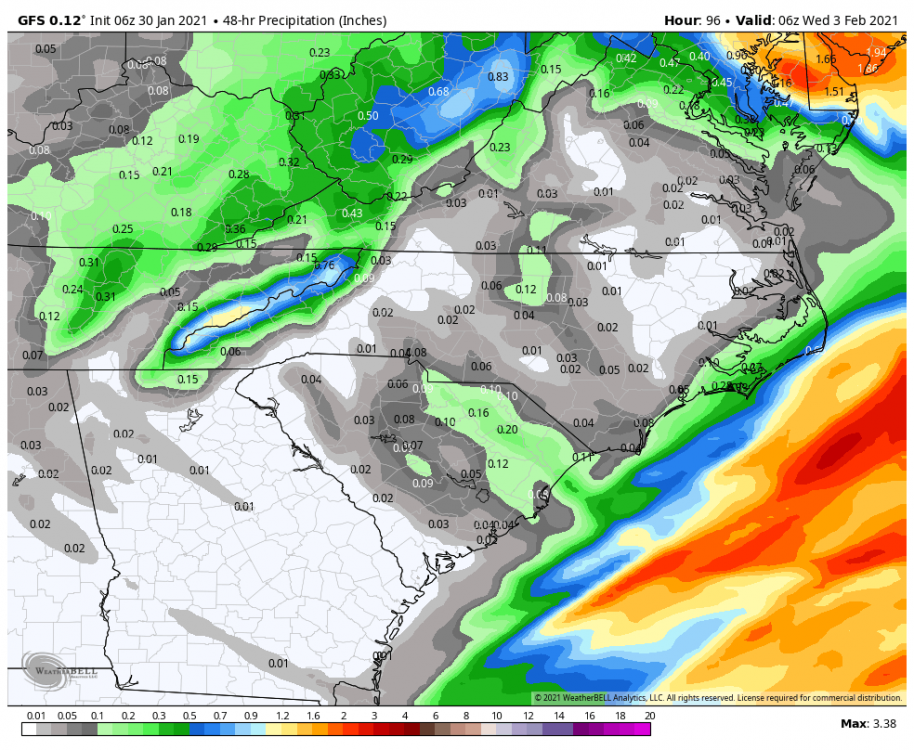
-
2020/2021 Fall/Winter Mountain thread
MotoWeatherman replied to Met1985's topic in Southeastern States
Got at least 4 inches here on Beech. -
2020/2021 Fall/Winter Mountain thread
MotoWeatherman replied to Met1985's topic in Southeastern States
Probably 2-3 inches here on Beech. Best precip is about to exit stage right. -
2020/2021 Fall/Winter Mountain thread
MotoWeatherman replied to Met1985's topic in Southeastern States
Thunder snow on Beech. Just watch. Cam_East-193347-193402.mp4 -
2020/2021 Fall/Winter Mountain thread
MotoWeatherman replied to Met1985's topic in Southeastern States
33 and all snow here at 4650 on Beech. Everything is already covered quickly. -
2020/2021 Fall/Winter Mountain thread
MotoWeatherman replied to Met1985's topic in Southeastern States
Pouring down on Beech. Cam_East-233513-233523.mp4