MotoWeatherman
-
Posts
2,282 -
Joined
-
Last visited
Content Type
Profiles
Blogs
Forums
American Weather
Media Demo
Store
Gallery
Everything posted by MotoWeatherman
-

2023-2024 Fall/Winter Mountain Thread
MotoWeatherman replied to The Alchemist's topic in Southeastern States
About the same here on the Beech. Flow band looks locked in up here so maybe it will over perform. Lol -
2023-2024 Fall/Winter Mountain Thread
MotoWeatherman replied to The Alchemist's topic in Southeastern States
Snow just started here on Beech -
2023-2024 Fall/Winter Mountain Thread
MotoWeatherman replied to The Alchemist's topic in Southeastern States
Sadly I don't trust the NAM outside 24 hours. Usually the GFS does a decent job even with the lower resolution. It's rare for the GFS to totally whiff and the NAM wins but it's not impossible. -
2023-2024 Fall/Winter Mountain Thread
MotoWeatherman replied to The Alchemist's topic in Southeastern States
And the 18z GFS says almost zero flow snow. -
2023-2024 Fall/Winter Mountain Thread
MotoWeatherman replied to The Alchemist's topic in Southeastern States
One thing the globals are not picking up on that the NAMs are is a direct moisture fetch off lake Michigan late Monday into Monday. Combine that with the really cold 850s and you have a recipe for a good flow event. But it's the NAM and over 24 hours out. But it's something to watch evolve for sure. -
2023-2024 Fall/Winter Mountain Thread
MotoWeatherman replied to The Alchemist's topic in Southeastern States
This weekend's potential upper level low needs to be watched closely. Typically in years past the ULL would trend stronger as the model runs get closer and closer. This is not that far off from being a major whopper for the mountains come Sunday night into Monday. -
2023-2024 Fall/Winter Mountain Thread
MotoWeatherman replied to The Alchemist's topic in Southeastern States
38 at 4650 on Beech with snow flakes mixing in. -
2023-2024 Fall/Winter Mountain Thread
MotoWeatherman replied to The Alchemist's topic in Southeastern States
Closer in shot of 18z 3k NAM. Too bad it's the NAM but it's big run for sure.
-
2023-2024 Fall/Winter Mountain Thread
MotoWeatherman replied to The Alchemist's topic in Southeastern States
3k 18z NAM smokes the mountains and more places in the lee of the mountains.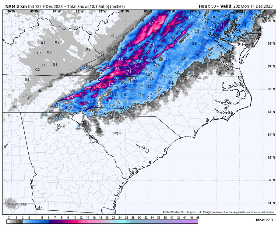
-
2023 Mountains Spring/Summer Thread
MotoWeatherman replied to Tyler Penland's topic in Southeastern States
What's your end goal? Best snow? Best food? Most "city" like? Best Snow....Beech or Sugar Mtn - above 4300. Higher the better obviously. I know all about Lodges at Eagles Nest as it's basically on an extension of Beech Mtn. You can literally walk from the top of that neighborhood over the ridge to Beech mtn resort. Do it all the time. Wife and I like to jog and run through the Emerald outback of Beech to the highest road that takes you to the top near their sky bar if you will. I would not buy any property lower than the Great Camp in elevation. Boone...great if you just want to be near the hustle and bustle. Not so great for snow and it does get quite warm there...compared to Beech Mtn. Blowing Rock...cool town with a great vibe and good food. Better position for CAD ice events but not as prime for snow. What is your experience with the Lodges at Eagles Nest? -
2022-2023 Fall/Winter Mountains Thread
MotoWeatherman replied to BlueRidgeFolklore's topic in Southeastern States
Over 4 inch and still coming down. Wish I would have came up to see it. -
2022-2023 Fall/Winter Mountains Thread
MotoWeatherman replied to BlueRidgeFolklore's topic in Southeastern States
Solidly over 3 inches now here on Beech. -
2022-2023 Fall/Winter Mountains Thread
MotoWeatherman replied to BlueRidgeFolklore's topic in Southeastern States
Same snowfall here in Beech at 4650. 2 inches and still coming down at a decent clip. -
2022-2023 Fall/Winter Mountains Thread
MotoWeatherman replied to BlueRidgeFolklore's topic in Southeastern States
Got about an inch so far here at 4650 on Beech. Temp finally dropped below freezing at 31.7. -
2022-2023 Fall/Winter Mountains Thread
MotoWeatherman replied to BlueRidgeFolklore's topic in Southeastern States
38.4 and rain at 4650 on Beech. This whole thing went down the toilet in a hurry. Lol -
2022-2023 Fall/Winter Mountains Thread
MotoWeatherman replied to BlueRidgeFolklore's topic in Southeastern States
100 percent liquid snow here at 4650 on Beech. Temp is 37.4. -
2022-2023 Fall/Winter Mountains Thread
MotoWeatherman replied to BlueRidgeFolklore's topic in Southeastern States
Where are you? -
2022-2023 Fall/Winter Mountains Thread
MotoWeatherman replied to BlueRidgeFolklore's topic in Southeastern States
That's become your DP is so dang low the rain is freezing due to evaporative cooling on the way down. It should turn over to plain rain before long. -
2022-2023 Fall/Winter Mountains Thread
MotoWeatherman replied to BlueRidgeFolklore's topic in Southeastern States
LOL...looking more and more like rain at that time. I'm in Dahlonega GA right now and was debating going up to Beech. But I'm holding off until the Saturday morning runs to make that call. -
2022-2023 Fall/Winter Mountains Thread
MotoWeatherman replied to BlueRidgeFolklore's topic in Southeastern States
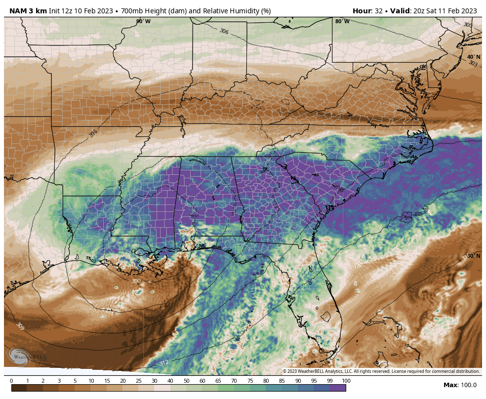
Gotta love the 3k NAM literally sucking in dry air and wrapping around the ULL thus choking off the precip. Thanks God its the NAM showing this right now and not the GOOFUS or EURO.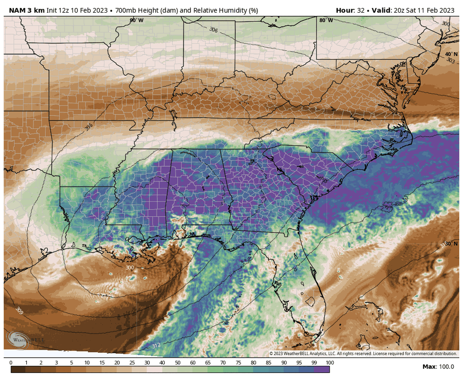
-
2022-2023 Fall/Winter Mountains Thread
MotoWeatherman replied to BlueRidgeFolklore's topic in Southeastern States
12 NAM starts to rapidly strengthen the ULL over southern AL versus GA this run vs 0z last night. This pulls it NE sooner which is doom in my opinion. One thing you can almost always count on is that the warm nose will be underdone on the models. -
2022-2023 Fall/Winter Mountains Thread
MotoWeatherman replied to BlueRidgeFolklore's topic in Southeastern States
Warm nose will potentially affect northern mountains the most for a period which sucks. -
2022-2023 Fall/Winter Mountains Thread
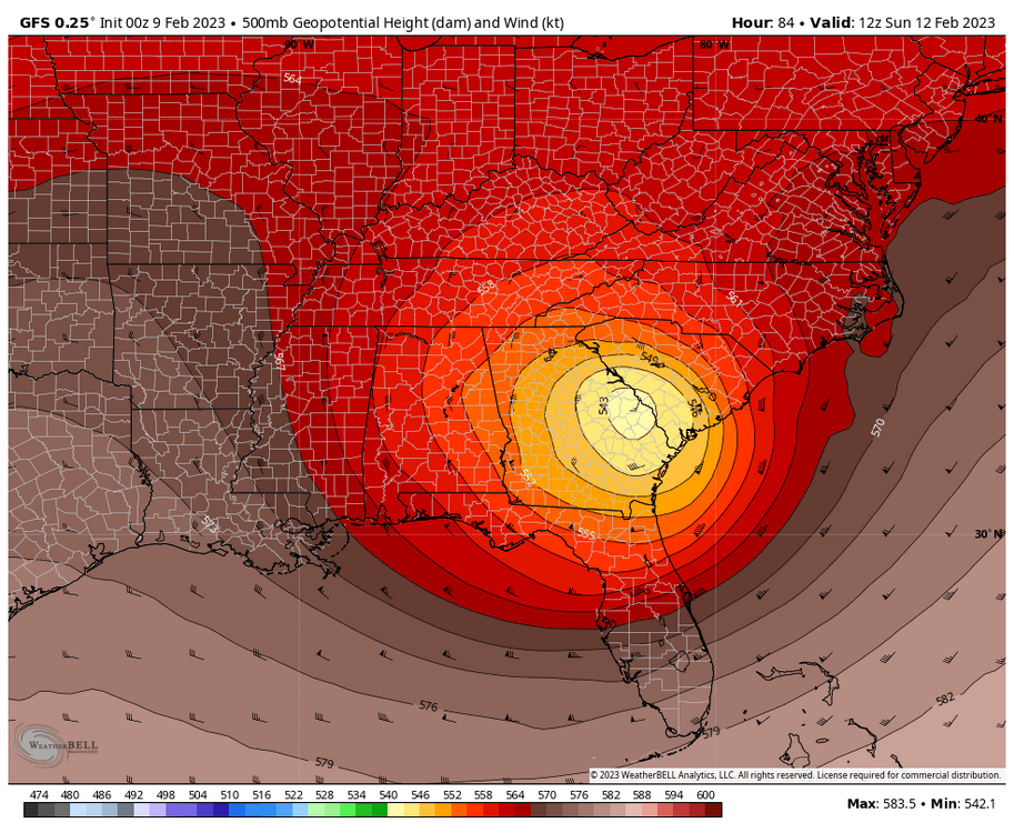
MotoWeatherman replied to BlueRidgeFolklore's topic in Southeastern States
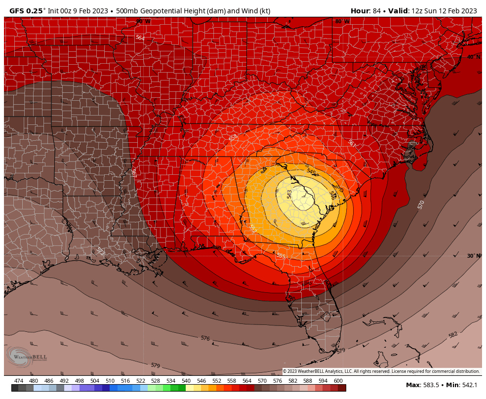
The 0z NAM and GFS are almost identical at 84hr. Once the ULL cuts off and drops down to the Gulf coast, then it's just ENE movement and strengthening. The GFS is stronger this run versus 18z. If we can get this track to hold it's paste job in the MTN's for sure. Also these stronger runs both show a warm nose affecting areas briefly Sunday morning...especially the northern mountains. The scenario could play out a snow to freezing rain/sleet back to snow type of deal. I've seen that happen before with these stupid warm noses. There is a reason they say "Upper Level Lows equals Weatherman's woes".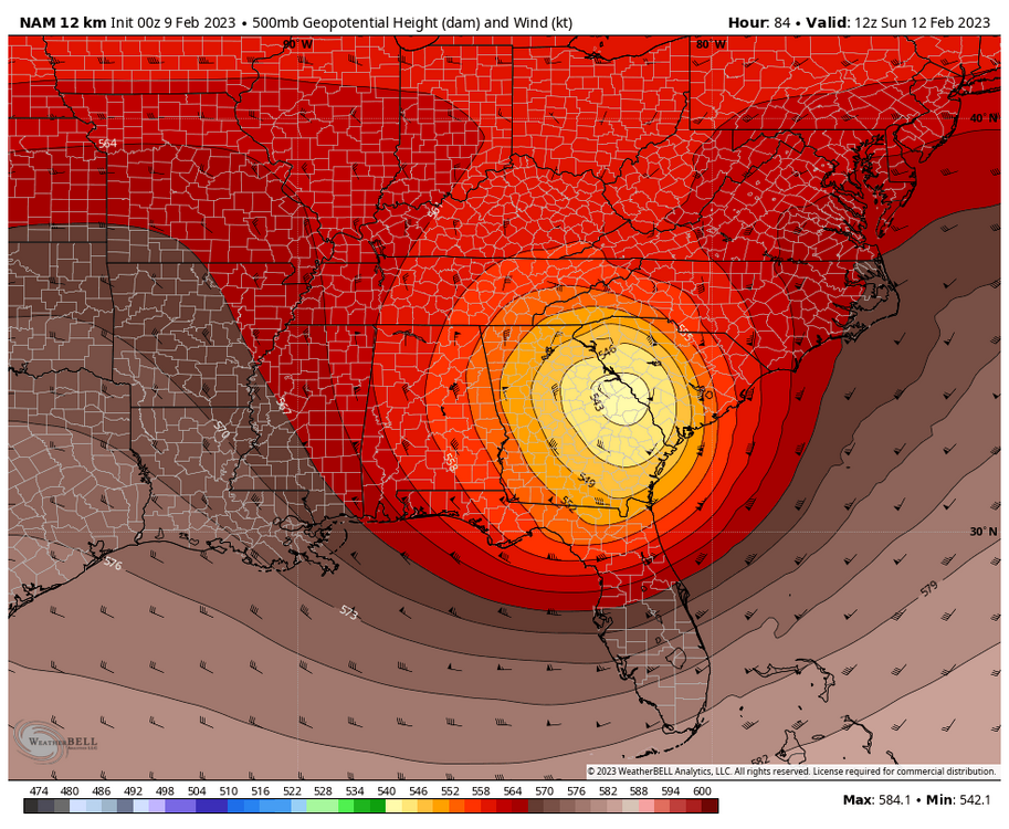
-
2022-2023 Fall/Winter Mountains Thread
MotoWeatherman replied to BlueRidgeFolklore's topic in Southeastern States
That's a very heavy dusting. -
2022-2023 Fall/Winter Mountains Thread
MotoWeatherman replied to BlueRidgeFolklore's topic in Southeastern States
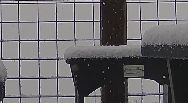
Over 2 inches now on the table at 4650 on Beech and dumping.