Wannabehippie
-
Posts
12,659 -
Joined
-
Last visited
Content Type
Profiles
Blogs
Forums
American Weather
Media Demo
Store
Gallery
Everything posted by Wannabehippie
-
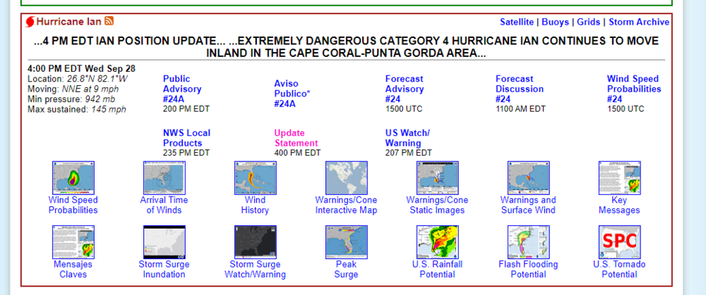
9:00 PM EDT Wed Sep 28Location: 27.3°N 81.6°WMoving: NNE at 8 mphMin pressure: 965 mbMax sustained: 105 mph
-
8:00 PM EDT Wed Sep 28Location: 27.2°N 81.7°WMoving: NNE at 8 mphMin pressure: 960 mbMax sustained: 115 mph
-
Once it is in the air it is different, as it is no longer grounded. Similar to an airplane.
-
Ivan? Plus no rocket should get hit with lightning, which is a possibility as well.
-
-
After Irma, my parents had no power for 3 days. They got lucky I guess.
-
7:00 PM EDT Wed Sep 28Location: 27.1°N 81.8°WMoving: NNE at 8 mphMin pressure: 955 mbMax sustained: 125 mph
-
-
6:00 PM EDT Wed Sep 28Location: 27.0°N 81.9°WMoving: NNE at 8 mphMin pressure: 951 mbMax sustained: 130 mph
-
The problem is that shelters will not take pets, which is a real shame. So people make the choice of staying in place, or leaving their pets behind.
-
That sounds legit. Charleston, SC better keep their eyes on Ian for the next landfall.
-
My guess is most of Tampa Bay is under water, either from tidal flooding, or from tremendous rainfall. All that rain has no where to go, leaving streets flooded, even away from the shore.
-
18z GFS has Ian back over water by 0z on Friday. Going to be a long night tonight, in to tomorrow for central, northern Florida in terms of rain and wind as Ian moves across. South east Florida should start to see improving conditions overnight tonight.
-
That is where Hurricane Josh is at. We should get some good info from him on Ian.
-
Power is out, cell towers are down. You may not hear anything until power comes back up. I hope she is in a safe place.
-
Gotta use anything you can to keep that mic dry. Condom works as well as anything else.
-
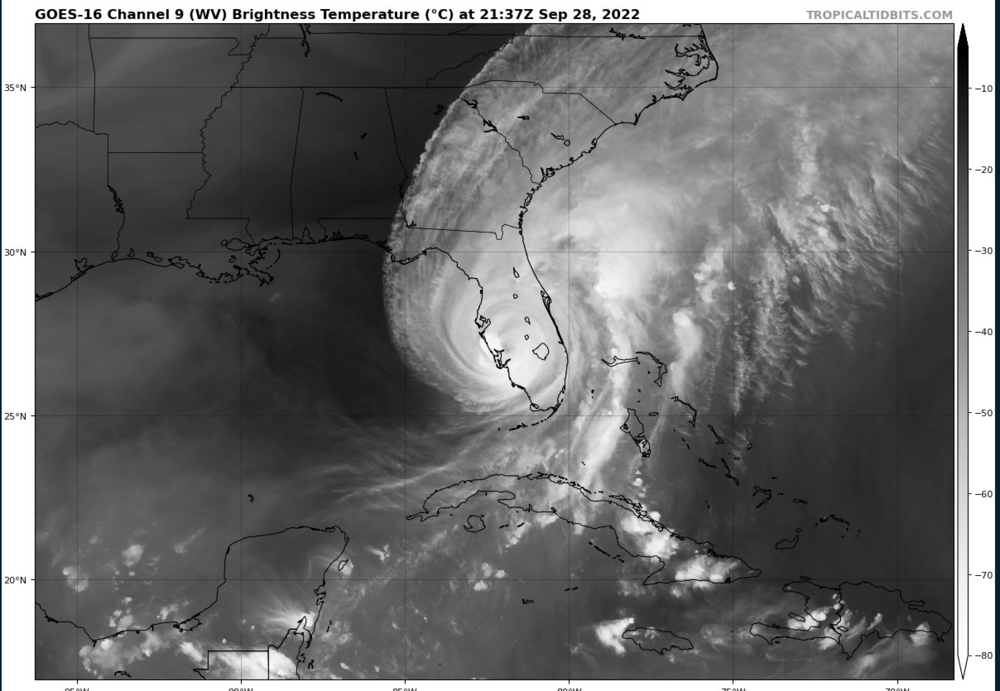
Looks like the eye is filling in a bit, now that Ian is over land.
-
AT 526 PM EDT, NATIONAL WEATHER SERVICE DOPPLER RADAR INDICATED EXTREME WINDS, ASSOCIATED WITH THE EYEWALL OF HURRICANE IAN, WERE MOVING ONSHORE OVER CHARLOTTE COUNTY AIRPORT, OR NEAR PUNTA GORDA. THE HURRICANE EYEWALL WAS MOVING SLOWLY NORTHEAST AT 5 MPH. THIS IS AN EXTREMELY DANGEROUS AND LIFE-THREATENING SITUATION! as per TornadoHQ.
-
Eye passing thru, no winds, so water went back out as far as it could?
-
I hope they all have adequate hurricane insurance. So many got cancelled recently, and had to go to the state for the insurance of last resort.
-
Anything in the direct path of Ian is getting crushed. Wind damage, tidal flooding appear to be the biggest damage makers so far. Only a few reports of small tornadoes.
-
A bit bantery, but you know Ian is serious, the Waffle houses in the path of Ian have closed.
-
Other states will be sending down staff soon as well.
-
I saw a video that Lee Goldberg posted on twitter, of a number of boats floating free of the dock. You would think they were under power, but they are free floating, moving fast.
-
Winds down a touch on the 4pm advisory.