HighTechEE
-
Posts
567 -
Joined
-
Last visited
Content Type
Profiles
Blogs
Forums
American Weather
Media Demo
Store
Gallery
Everything posted by HighTechEE
-
My first flake of the storm just happened, buddy of mine has heavy snow 9 miles north of me, my daughter 9 miles SW of me has heavy snow, still heavy sleet here, but a couple tiny flakes trying to mix in FINALLY EDIT: Forgot to mention 1.5" of sleet total, hopefully NO MORE.
-
1.2" of rain yesterday, 0.5" liquid equivalent today ups my missed snow total to a foot and a half, still no snow at 24.8°
-
1pm and still no snow IMBY, only sleet and lots of it at 25°
-
Unfortunately here on the SE side of Dayton we regressed back to half sleet AND FR as the temps steadily fall at 25.3 degrees now! This is ridiculous, not far from the horror of Feb '94 , I just went out a scrapped a couple spots on my sidewalk looks like 0.2" of ice, 0.25 sleet. ILN did an update and has us mixing with snow at noon then all snow at 1pm becoming heavy for the rest of the afternoon with possible totals IMBY of 10+ inches by tmar morning.
-
We're having the heaviest sleet of the storm right now and no snow at all at 26.2 degrees and steadily falling, my daughter lives 10 miles SW of me in N Warren Co, she went over to snow back at 9am (Wright Brothers/Dayton General airport is a couple miles west of her)??? Also I just saw Jim Cantore is in Columbus today, we'll get to see him dance & go nuts when the Thundersnow hits about 5 or 6pm today!
-
Woke up to see ILN has launched me into the 8-12" range now w/transition to snow moved up 12hrs! We had some FR overnight, a good bit of sleet, now 90% sleet with snow mixing in at 28.8 degrees on the SE side of Dayton.
-
Oh yea especially when it comes to "major winter storms" that takes 36 to 48 hours to 'begin' to snow when the heavy snow was only 6 counties away to start! Edit: 1.10" of cold rain now ~ 13"-ish of missed snow.
-
I'm up to loosing officially a foot of snow so far today IMBY with 0.99" of cold rain in the gauge
-
Yea I suspect plus what ever sleet is modeled.
-
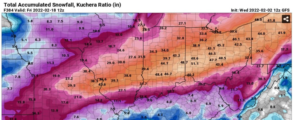
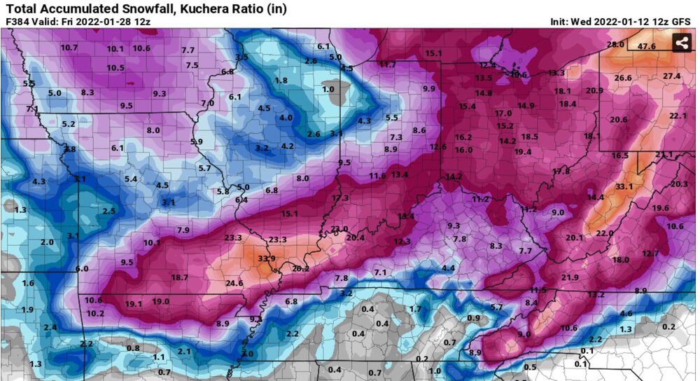
Yea 20 miles north or south is big deal with this one in our neck of the woods! That matrix of data is GFS, but it's not noted anywhere on this page, I have this one for area code 45305 (Bellbrook) and the one for KDAY is obviously much different: MeteoStar Home > Forecast > Bellbrook, OH The 12z is about exactly the same as the 06z where the column goes below 0C and stays there at 06z (1am here) while 1.4" of liquid equivalent still falls for the duration of the 2nd wave. BTW anyone get a load of the 12z GFS 384 eye candy map of KDAY getting over 4ft of snow the next two weeks! Boy and girls this is a new record!!!
-
I've noticed that the last couple days worth of GFS runs has the entire column (925 on down) going below freezing about 06z tonight right after midnight EST and staying that way for the duration of the storm with about 1.4" of liquid equivalent falling which should be in the form of snow, not mostly sleet as the NWS is calling for in the Dayton area. How can that be if there is no liquid falling to turn into sleet? FCST Hour Valid Time 2mT °F Max Temp °F Min Temp °F Td °F 10m Wind mph 925mb Wind mph 850mb Wind mph Total Precip(") Accum Precip Conv Precip(") 500-1000 THKNS 500mb Height 500mb Temp°C 850mb Temp°C 925mb Temp°C MSLP mb Total Cloud Cover 700mb VV 850mb Td(°C) swrd 3 Wed 02/02 09Z 40.3 41.5 40.2 33.3 S 11 SSW 37 SSW 30 0.00" 0.00" 548 5633.7 -19.0 -1.6 8.0 1019.2 100.0 -0.1 -5° 0.0 6 Wed 02/02 12Z 39.4 41.5 39.0 33.1 S 11 SSW 37 SSW 31 0.00" 0.00" 546 5628.8 -17.8 -2.5 6.3 1020.6 100.0 -0.6 -11° 0.0 9 Wed 02/02 15Z 40.6 40.8 38.9 39.5 SSW 11 SSW 33 SSW 47 0.15" 0.15 0.00" 545 5621.2 -17.5 -3.0 4.9 1021.2 100.0 -1.0 -3° 10.3 12 Wed 02/02 18Z 40.6 42.5 38.9 39.0 SSE 15 S 33 SW 68 0.26" 0.41 0.00" 546 5617.3 -17.6 -1.9 3.4 1019.2 100.0 -1.1 -2° 21.0 15 Wed 02/02 21Z 40.3 41.1 39.7 38.7 S 14 S 29 SW 45 0.12" 0.53 0.00" 546 5605.7 -18.7 -0.9 3.1 1017.8 100.0 -0.7 -1° 13.0 18 Thu 02/03 00Z 40.4 41.4 39.5 39.5 S 11 S 26 WSW 45 0.12" 0.65 0.00" 546 5607.1 -18.5 -1.1 3.8 1017.6 100.0 -0.8 -1° 7.3 21 Thu 02/03 03Z 39.2 40.7 38.8 38.7 S 1 SW 13 WSW 48 0.10" 0.75 0.00" 546 5610.0 -17.8 -1.3 4.4 1018.4 100.0 -0.2 -1° 0.0 24 Thu 02/03 06Z 30.8 40.9 30.7 29.3 N 14 NNE 23 WSW 42 0.09" 0.84 0.00" 544 5609.5 -17.6 -1.9 -2.1 1021.1 100.0 -0.6 -2° 0.0 27 Thu 02/03 09Z 27.4 30.7 27.4 25.8 NNE 14 NNE 27 SW 47 0.11" 0.95 0.00" 543 5608.2 -18.4 -1.4 -4.6 1022.0 100.0 -0.5 -2° 0.0 30 Thu 02/03 12Z 25.7 30.7 25.7 24.0 NNE 15 NNE 29 SW 50 0.11" 1.06 0.00" 542 5612.2 -17.9 -0.8 -6.1 1024.2 100.0 -0.6 -1° 0.0 33 Thu 02/03 15Z 23.2 25.6 23.2 21.1 NNE 16 NNE 31 SW 42 0.06" 1.12 0.00" 542 5617.0 -16.1 -1.3 -7.6 1024.7 100.0 -0.2 -1° 11.1 36 Thu 02/03 18Z 22.3 25.6 21.9 20.6 NNE 19 NNE 36 SW 36 0.20" 1.32 0.00" 544 5617.4 -15.1 -0.8 -7.7 1022.4 100.0 -0.2 -1° 26.5 39 Thu 02/03 21Z 20.2 22.4 20.2 18.3 NNE 20 NNE 38 SSW 30 0.35" 1.67 0.00" 544 5607.5 -13.2 -1.3 -8.7 1021.1 100.0 -0.7 -1° 39.4 42 Fri 02/04 00Z 18.0 22.4 18.0 15.9 NNE 20 NNE 39 WSW 17 0.35" 2.02 0.00" 542 5603.7 -13.6 -2.7 -9.9 1023.6 100.0 -0.4 -3° 22.7 45 Fri 02/04 03Z 16.9 17.9 16.9 14.4 NNE 18 NNE 35 W 13 0.13" 2.15 0.00" 541 5597.6 -13.7 -3.0 -10.6 1024.3 100.0 0.1 -3° 0.0 48 Fri 02/04 06Z 15.6 17.9 15.6 13.2 NNE 16 NNE 32 WSW 10 0.02" 2.17 0.00" 539 5579.6 -15.5 -3.7 -11.4 1025.4 100.0 -0.0 -4° 0.0 51 Fri 02/04 09Z 14.8 15.6 14.8 12.4 NNE 15 NNE 30 WNW 14 0.04" 2.21 0.00" 536 5556.4 -17.2 -4.6 -11.8 1025.7 100.0 0.2 -5° 0.0 54 Fri 02/04 12Z 13.9 15.6 13.9 11.2 N 14 NNE 28 WNW 16 0.03" 2.24 0.00" 533 5540.2 -21.1 -7.0 -12.4 1028.1 100.0 -0.0 -8° 0.0 57 Fri 02/04 15Z 14.6 14.7 13.5 11.4 N 12 NNE 23 WNW 17 0.01" 2.25 0.00" 530 5526.5 -24.2 -8.5 -12.5 1029.7 100.0 -0.0 -14° 81.5 PS - I've officially lost 2" of snow as my rain gauge has 0.2" so far (assuming it would be a 10 to 1 ratio).
-
Dude, read the sub topic "Ohio and Surrounding States", Ohio does NOT HAVE THEIR OWN DISCUSSION!
-
Looking down the road two weeks from today 12z GFS has KDAY at -28.2 for the morning low!!! There would have to be a serious amount of snow on the ground to achieve that. 300 Sat 02/12 00Z 5.2 18.9 5.2 -0.7 WNW 13 WNW 23 WSW 64 0.00" 0.00" 514 5371.9 -30.2 -15.5 -17.8 1030.4 100.0 0.1 -16° 260.0 303 Sat 02/12 03Z -0.8 5.1 -0.8 -6.8 WNW 12 WNW 22 WSW 60 0.00" 0.00" 512 5360.3 -30.1 -16.8 -21.4 1033.0 100.0 -0.2 -19° 0.0 306 Sat 02/12 06Z -4.9 5.1 -4.9 -11.2 WNW 11 WNW 21 WSW 55 0.00" 0.00" 508 5334.4 -30.0 -19.1 -23.8 1034.3 100.0 -0.0 -25° 0.0 309 Sat 02/12 09Z -12.0 -5.0 -12.0 -18.2 WNW 9 NW 22 WSW 49 0.00" 0.00" 505 5302.1 -29.2 -21.0 -25.8 1035.2 24.7 0.1 -46° 0.0 312 Sat 02/12 12Z -24.6 -5.0 -24.6 -30.5 W 6 NW 20 W 41 0.00" 0.00" 501 5275.5 -30.3 -23.4 -26.5 1037.5 5.3 0.0 -49° 0.0 315 Sat 02/12 15Z -16.5 -16.5 -25.9 -23.2 WNW 8 NW 16 W 33 0.00" 0.00" 499 5252.0 -31.1 -25.7 -26.9 1037.6 5.0 0.1 -47° 162.1 318 Sat 02/12 18Z -7.6 -7.6 -25.9 -15.2 WNW 10 WNW 13 W 29 0.00" 0.00" 496 5220.8 -32.8 -27.8 -26.0 1035.7 97.2 0.0 -45° 385.5 321 Sat 02/12 21Z -5.4 -5.3 -7.5 -13.6 WNW 11 WNW 16 WNW 28 0.00" 0.00" 493 5184.2 -35.8 -29.9 -24.4 1034.9 100.0 -0.1 -44° 560.0 324 Sun 02/13 00Z -13.4 -5.3 -13.4 -19.5 W 8 WNW 22 WNW 25 0.00" 0.00" 490 5169.9 -37.0 -31.1 -25.4 1037.0 30.3 0.1 -44° 331.3 327 Sun 02/13 03Z -21.0 -13.6 -21.0 -26.9 W 6 WNW 23 NW 23 0.00" 0.00" 490 5177.6 -36.5 -31.6 -25.8 1038.8 5.6 0.2 -42° 0.0 330 Sun 02/13 06Z -24.7 -13.6 -24.7 -30.7 WSW 6 NW 20 NW 25 0.00" 0.00" 493 5211.7 -31.5 -30.6 -25.0 1039.7 7.3 0.2 -43° 0.0 333 Sun 02/13 09Z -27.1 -24.8 -27.1 -33.2 WSW 5 WNW 19 NW 29 0.00" 0.00" 499 5278.9 -28.5 -28.4 -24.2 1041.0 5.0 0.3 -44° 0.0 336 Sun 02/13 12Z -27.8 -24.8 -28.2 -34.0 WSW 3 NW 12 NW 36 0.00" 0.00" 505 5343.2 -27.7 -23.5 -22.9 1041.9 5.0 0.3 -49° 0.0 339 Sun 02/13 15Z -12.1 -12.1 -27.7 -19.6 WSW 5 W 6 NW 31 0.00" 0.00" 509 5395.4 -27.4 -21.2 -22.8 1042.9 5.0 0.4 -47° 164.6 342 Sun 02/13 18Z -1.2 -1.2 -27.8 -9.8 SW 6 SW 8 NW 26 0.00" 0.00" 511 5420.3 -26.8 -20.0 -22.8 1042.2 77.6 0.2 -47° 374.2 345 Sun 02/13 21Z 2.9 2.9 -1.1 -6.5 SSE 3 SSE 5 W 28 0.00" 0.00" 514 5433.5 -26.8 -17.3 -20.2 1040.1 98.8 0.2 -41° 522.7 348 Mon 02/14 00Z 3.7 3.8 -1.1 -2.2 ESE 4 SSE 11 W 30 0.00" 0.00" 515 5450.2 -26.5 -15.7 -18.8 1040.2 100.0 -0.1 -16° 299.1 351 Mon 02/14 03Z 4.4 4.4 3.7 0.3 ESE 6 SSE 16 WSW 39 0.00" 0.00" 517 5460.4 -26.8 -16.5 -17.1 1039.6 100.0 -0.1 -17° 0.0 354 Mon 02/14 06Z 6.8 6.8 3.7 2.0 SE 7 S 20 WSW 41 0.00" 0.00" 517 5461.9 -28.5 -16.1 -15.9 1038.8 100.0 -0.1 -16° 0.0 357 Mon 02/14 09Z 6.2 7.6 5.9 2.0 SE 6 SSW 18 WSW 44 0.00" 0.00" 518 5472.3 -27.4 -16.3 -14.6 1038.5 100.0 -0.2 -16° 0.0 360 Mon 02/14 12Z 6.4 7.7 5.6 1.7 SSE 7 SW 20 WSW 48 0.00" 0.00" 521 5499.4 -24.8 -13.9 -12.8 1038.5 98.3 -0.0 -14° 0.0
-
OMG! LMAO, I needed that one, thank you sir!
-
Next Thurs 06z GFS had a monster ice storm for the Ohio I-71 corridor, 12z is a 200 miles whiff to the north, almost 3ft for N. Indiana/S. Mich.
-
Wow Jan '67, my personal all time best, 28" of heavy wet snow in 24hrs in the NW corner of Athens Co in SE Ohio. We were getting 6" every 4hrs for 12hrs in a row, some flakes were the size of the palm of my 7yr old hand! We have to shovel off our carport roof as my dad was afraid it was going to colapse!
-
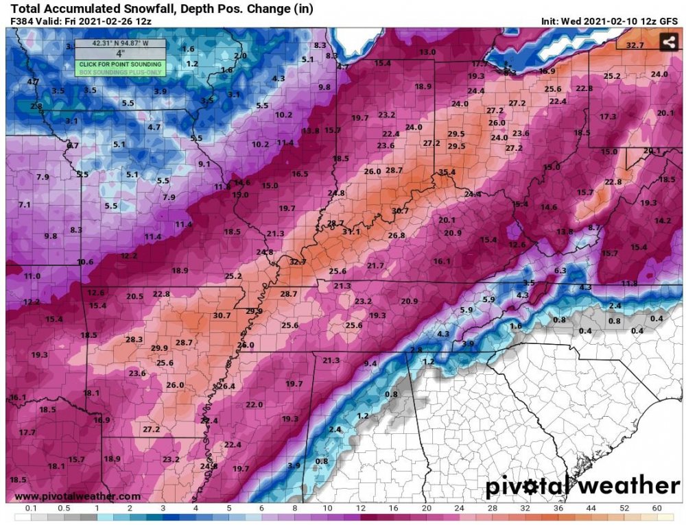
Add this one to your wall from last year! I think we may have got no snow at all from this eye candy map.
-
Alright time for this nonsense to stop, The Lets Talk Winter thread has been around since this EasternWX days and it has a subtitle "Ohio and Surrounding States" NOT JUST OHIO, learn how to read people! It's not our fault the powers at be created a subforum thread thats so big that some folks in different states could have no interest in states that are so far away. For instance the northern Min/Wis/UP areas have entirely different climates than the southeastern ones in this sub. Hence the Ohio and Surrounding States was created (thank you Steve) so these folks can be a little more focused as Buckeye eluded to recently.
-
The Japan Ocean Effect is quite impressive (we know what they're complaining about): Japan Ocean Effect
-
All snow IMBY and has got heavier with large flakes.
-
We got about a quarter of a skiff here on the SE side of Dayton, good bit of sleet had mixed in, back to mostly snow now.
-
Just started snowing little puffballs on the SE side of Dayton.
-
That's not a donut hole over N IL, its a bullet hole!!! (normally reserved for S Ohio)
-
Well not quite, 18z pushed it back a whole week with 5 - 8" snows for all of S. Ohio the end of next week (take that to the bank)
-
Great, Gulf Coast states gets more snow out of one storm than we get in most of our winter months: https://www.weather.gov/ Gatlingburg, TN 4 to 8" tonight into tmar morning, with a foot in the mountains.