ChescoWx
-
Posts
9,208 -
Joined
-
Last visited
Content Type
Profiles
Blogs
Forums
American Weather
Media Demo
Store
Gallery
Everything posted by ChescoWx
-
12k always an issue.....
-
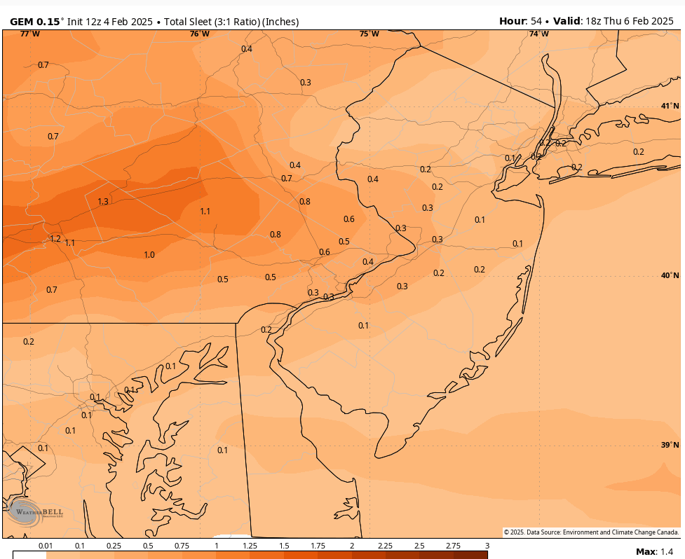
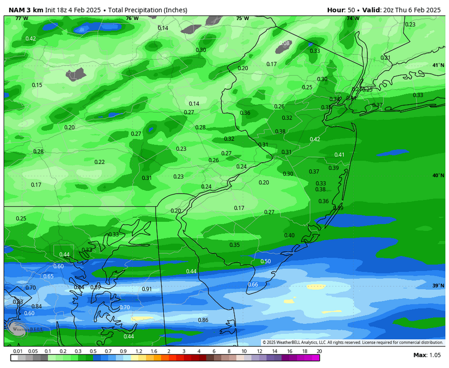
Not sure where you saw 0.80" - 18z actually cut total precipitation - see below
-
..WINTER WEATHER ADVISORY IN EFFECT FROM MIDNIGHT WEDNESDAY NIGHT TO NOON EST THURSDAY... * WHAT...Mixed precipitation expected. Total snow and sleet accumulations up to one inch and ice accumulations between one tenth and two tenths of an inch. * WHERE...Portions of northern New Jersey and east central, northeast, and southeast Pennsylvania. * WHEN...From midnight Wednesday Night to noon EST Thursday. * IMPACTS...Plan on slippery road conditions. The hazardous conditions could impact the Thursday morning commute.
-
Let's hope the below Euro solution plays out! No snow - small amount of sleet and somewhat less ZR. Warming comes in at least 3 hours faster than other models.
-
That Canadian solution would be far from swell.....
-

-
Agreed 100%
-
Only a trade for a Phillies World Series would get me on board! I love the Birds but The Phightins are #1 for me!!
-
12z NAM a little closer to what I envision with any accumulating snow well to the northeast of our area.
-
I supect any snow will be light with a quick change to some form of non-snow with this one!
-
The 12z HRRR with 2" to 4" of a little front end snow before a turn to sleet and ZR.
-
With a cold frontal passage this AM we have already reached our high temperature for the day. We should see our temperatures hold steady this morning then fall this afternoon. We should reach freezing during the 6pm hour across much of Chester and Berks Counties. We then look to stay below freezing tomorrow and through rush hour on Thursday. This sets the stage for a messy mix of snow to sleet to freezing rain before it tapers off from southwest to northeast on Thursday. Precipitation looks to arrive Wednesday evening. We get to do this all over again Saturday afternoon into evening.
-
The GFS only "slightly" shaved those 18z totals.....
-
Fingers and toes crossed the Euro is again king!! I am sure the other models are way overdoing the cold! I don't think any of us wants ice!!
-
18z NAM with snow / sleet and ZR would be quite the messy mix if it was to be believed...
-
18z NAM with snow / sleet and ZR would be quite the messy mix if it was to be believed...
-
The latest GFS runs has 4 winter events with all but this weekend's event having snow accumulation as part of the mix. This weekend on the model looks like mainly freezing rain changing to rain. Below are the 3 individual model snow events with 2 day totals over the next couple weeks. NOT A FORECAST! The first snow event is this Thursday. #2 is next Wednesday/Thursday and #3 is the weekend of the 14th-15th.
-
There continues to be an alarming rise in natural climate change deniers!! LOL!
-
The first model run of the day the 12z NAM which is a bit out of it's range has temperatures here at the surface staying below freezing all day Wednesday and through around 8 or 9am on Thursday. While that is happening warmer air will be moving in above us at around 5k feet. Meaning by about 4am on Thursday morning temperatures will be well above freezing where snow is made. This means whatever falls after that time will be some form of non-snow meaning sleet or freezing rain. Then it will be a race to see how we get the surface to warm for plain rain.
-
Our 0.3" of snow/sleet and then some freezing fog this morning resulted in multiple 2-hour school delays this morning. This week looks to feature significant fluctuations in temperatures with highs near 50 degrees today and again on Thursday.....but more snow, sleet, freezing rain and plain rain in our future starting on Wednesday afternoon and into Thursday morning. We may get to do the whole wintry mess all over again come Saturday later in the day.