ChescoWx
-
Posts
9,208 -
Joined
-
Last visited
Content Type
Profiles
Blogs
Forums
American Weather
Media Demo
Store
Gallery
Everything posted by ChescoWx
-
-
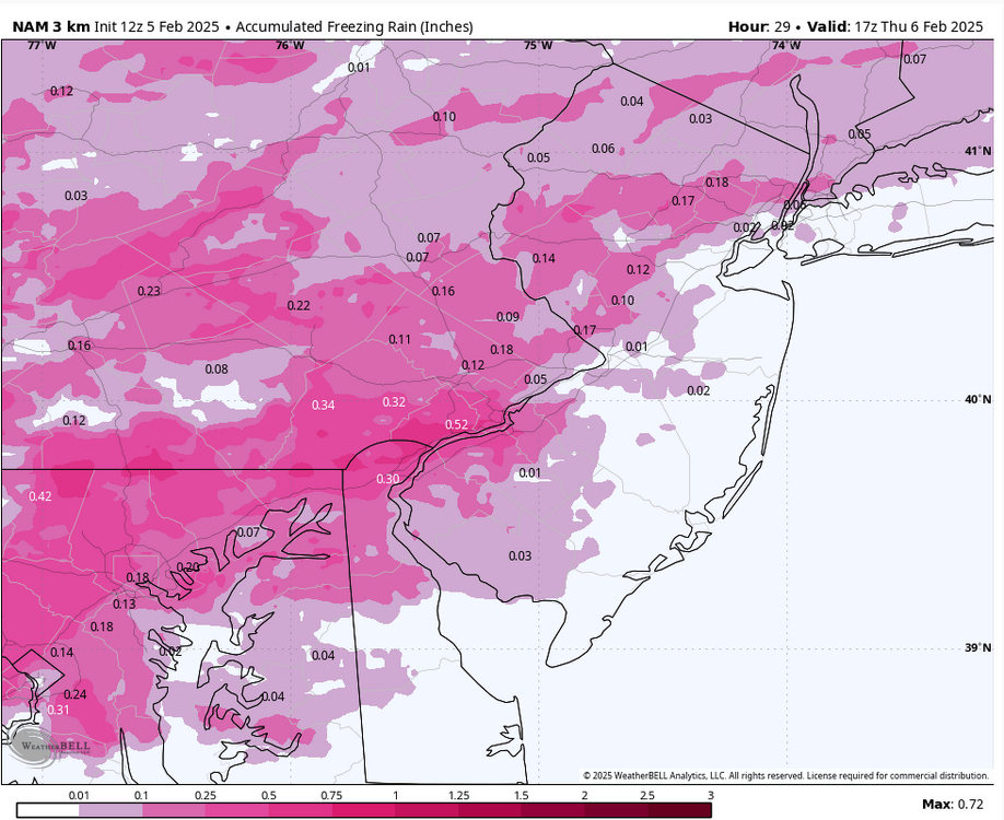
Still some lite ZR here in East Nantmeal....couple ice pics as of 1130am
-
About 0.15" of this was from this AM
-
-
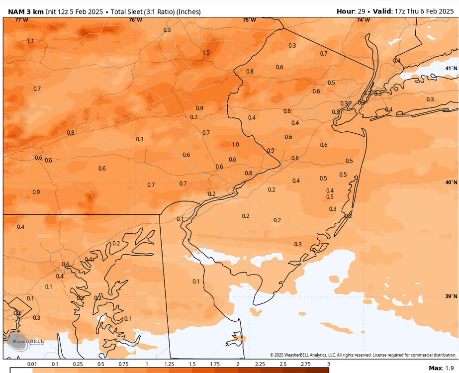
29.5 here in East Nantmeal with ZR 0.3" of sleet overnight
-
Still ZR Temp 29.5 with 0.3" of sleet
-
Sleet/IP Mix temp 27.8 all surfaces coated
-
Anything that falls after 9am would be non-snow if the 850mb temps are correct
-
Always buy the NAM on snow vs non snow....much better NAM run - significantly less ZR - still little or no snow in Eastern PA and similar sleet totals.
-
You think someone likes that garbage??
-
Here's hoping we all warm up faster than modeled!! No one likes ice!!
-
32.7 here in NW Chesco DP 14.7
-
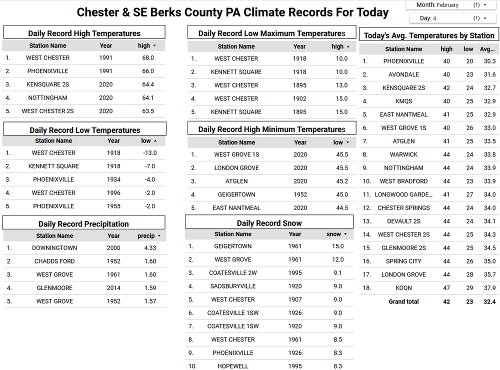
February is our snowiest month of the year. We average around 13" in a normal month. Below are the greatest snowstorms in Chester and SE Berks County history since 1893.
-
Yep that of course will always be the case as you near the coastal plain.....
-
February is our snowiest month of the year. We average around 13" in a normal month. Below are the greatest snowstorms in Chester and SE Berks County history since 1893.
-
Potential all over the place over the next 2 weeks
-


-
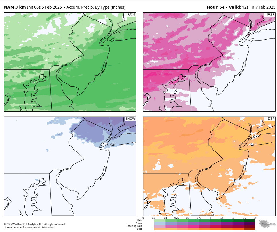
Hoping the NAM is drunk again as while it has almost no snow for anyone in PA it does have quite a bit of sleet followed by ZR - up to 1/3 inch of ice for my area would be far from swell.....
-
Hoping the NAM is drunk again as while it has almost no snow for anyone in PA it does have quite a bit of sleet followed by ZR - up to 1/3 inch of ice for my area would be far from swell.....
-
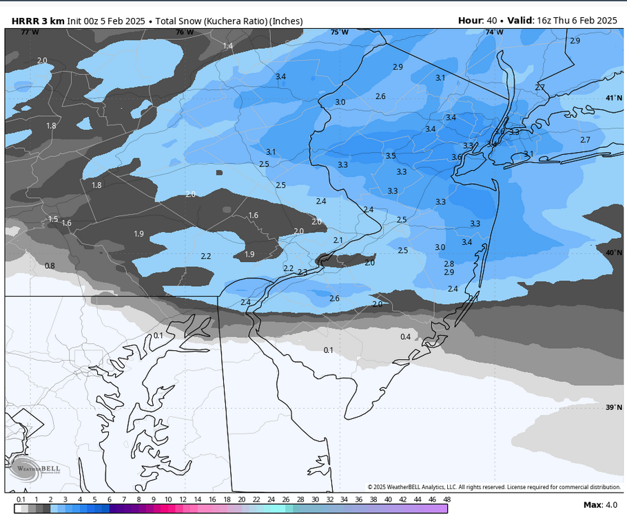
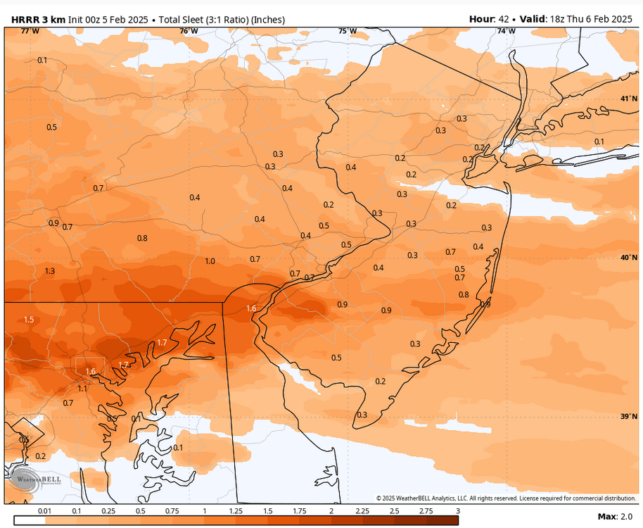
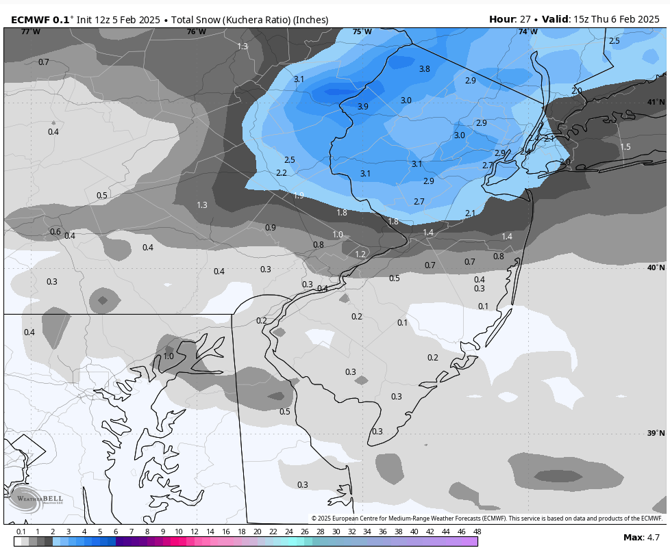
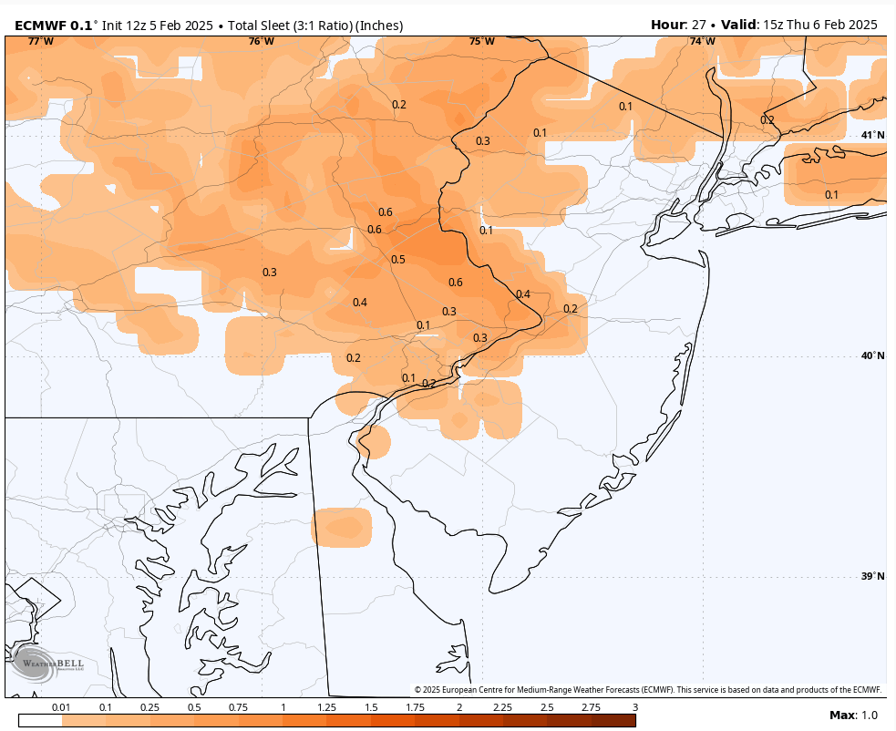
A busy wintry period of weather with 3 impactful winter events over the next 6 days. The first arrives late tonight with a brief snow to sleet to freezing rain. Several models show around 0.30" of ZR across Western Chester County which could result in slippery travel and power outages with that much ice. We get a break tomorrow afternoon through most of Saturday before snow arrives again on Saturday night before transitioning again to a messy mix before ending by Sunday morning. Snow may arrive again later Monday night and last until Tuesday.

-
A busy wintry period of weather with 3 impactful winter events over the next 6 days. The first arrives late tonight with a brief snow to sleet to freezing rain. Several models show around 0.30" of ZR across Western Chester County which could result in slippery travel and power outages with that much ice. We get a break tomorrow afternoon through most of Saturday before snow arrives again on Saturday night before transitioning again to a messy mix before ending by Sunday morning. Snow may arrive again later Monday night and last until Tuesday.
-

Central PA Banter (Banter Less?) Thread
ChescoWx replied to Itstrainingtime's topic in Upstate New York/Pennsylvania
Yes - sorry about that!! -
I think you are correct!
-
NAM showing no snow at all for anyone in PA but sleet and then still quite a bit of ZR - it has temps getting above freezing across most of PA by the 11am or noon tomorrow. IF this were correct some significant +0.25 amounts of ZR across Chester County

-
0Z HRRR has the burbs never getting above freezing till after precip stops with a couple inches of snow/sleet combo before some freezing drizzle to end. Of course not a forecast!