(002).png.f2cbd7c955dc3007a02ab79925b174ec.png)
ChescoWx
-
Posts
11,230 -
Joined
-
Last visited
Content Type
Profiles
Blogs
Forums
American Weather
Media Demo
Store
Gallery
Everything posted by ChescoWx
-
(002).thumb.png.6e3d9d46bca5fe41aab7a74871dd8af8.png)
Central PA Summer 2026 Discussion/Obs Thread
ChescoWx replied to Voyager's topic in Upstate New York/Pennsylvania
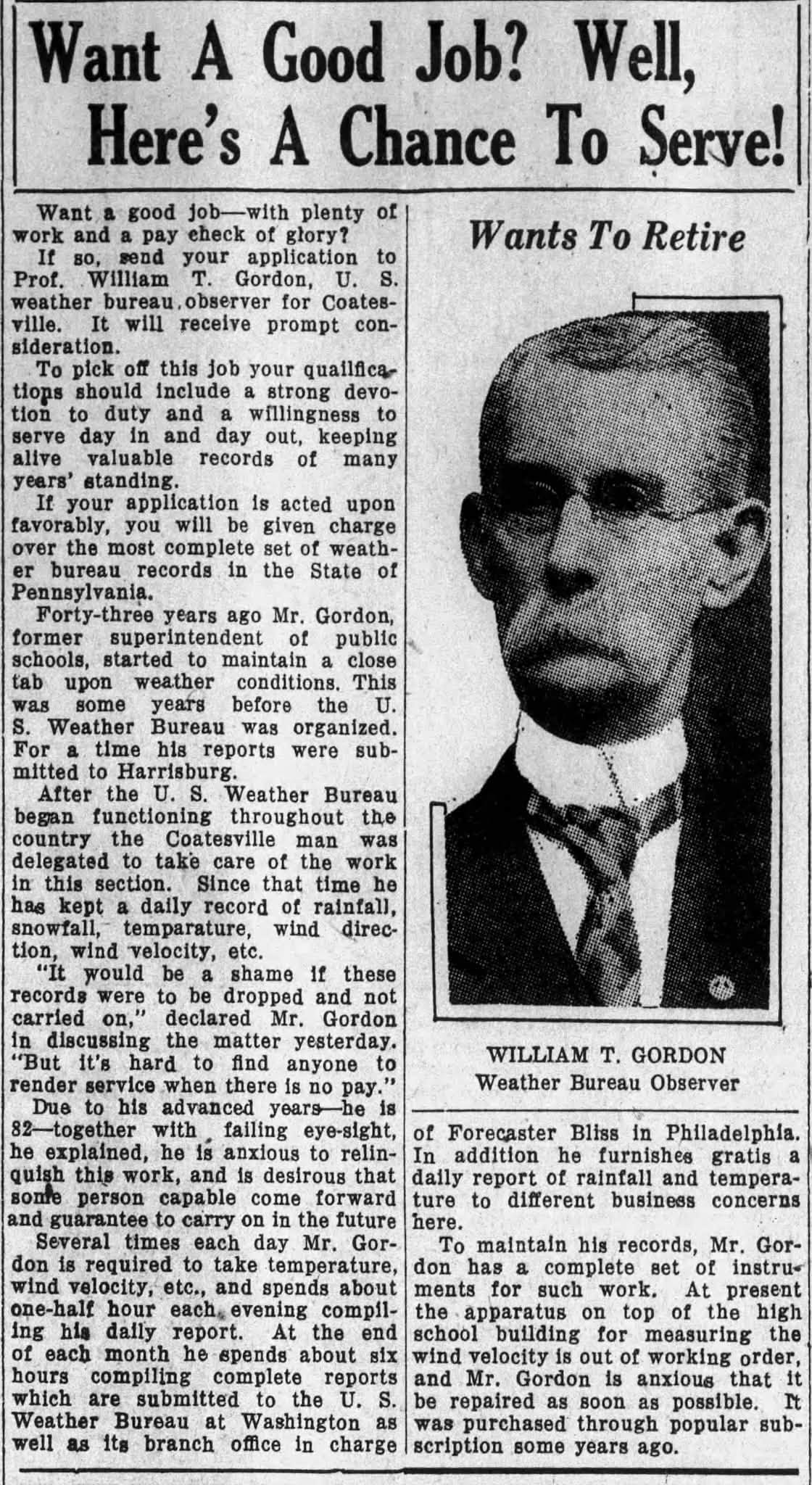
So cool (at least to me). Over on a local Facebook Page they posted the below article from 1930 about the original trained NWS Cooperative Observer for Coatesville PA - WT Gordon. Mr. Gordon (1888-1930) at that time he was looking to retire from observing the weather... but keep his legacy of accurate weather and climate reporting for Coatesville PA alive. Some of you may not know this but back in 1998 I actually purchased all of the handwritten NWS COOP pages from the NWS for Coatesville 1SW for every month from 1894 through 1948 (I know I am a weather nerd!) At the time this data was not available on the internet so during my many plane trips for work and in my spare time I transcribed by hand each and every day for all of those years into an excel spreadsheet the handwritten daily observations for those 54 years. When that was completed I accessed the data from 1948 through 1998 that was available on line to complete the data set for the NWS COOP stations of Coatesville 1SW (1893-1982) and Coatesville 2W (1983-2007).
-
E PA/NJ/DE Summer 2026 Obs/Discussion
ChescoWx replied to PhiEaglesfan712's topic in Philadelphia Region
So cool (at least to me). Over on a local Facebook Page they posted the below article from 1930 about the original trained NWS Cooperative Observer for Coatesville PA - WT Gordon. Mr. Gordon (1888-1930) at that time he was looking to retire from observing the weather... but keep his legacy of accurate weather and climate reporting for Coatesville PA alive. Some of you may not know this but back in 1998 I actually purchased all of the handwritten NWS COOP pages from the NWS for Coatesville 1SW for every month from 1894 through 1948 (I know I am a weather nerd!) At the time this data was not available on the internet so during my many plane trips for work and in my spare time I transcribed by hand each and every day for all of those years into an excel spreadsheet the handwritten daily observations for those 54 years. When that was completed I accessed the data from 1948 through 1998 that was available on line to complete the data set for the NWS COOP stations of Coatesville 1SW (1893-1982) and Coatesville 2W (1983-2007).
-
Central PA Summer 2026 Discussion/Obs Thread
ChescoWx replied to Voyager's topic in Upstate New York/Pennsylvania
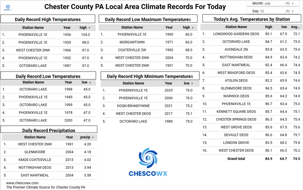
Several of our valley locations this morning saw lows down into the 50's with the ridges remaining in lower 60's. The lowest I could find was 56.3 at the Warwick DEOS. Today will be our 6th below normal temperature day over the last 8 days. We turn that around tomorrow with highs well into the 80's with 90's in the valley spots. Widespread 90's on Wednesday before we back off several degrees by Thursday. So not many spots across Chesco will get to "enjoy" the so called "heat wave" this week. By next weekend we return to near normal temperatures with increasing chances of some showers.

-
E PA/NJ/DE Summer 2026 Obs/Discussion
ChescoWx replied to PhiEaglesfan712's topic in Philadelphia Region
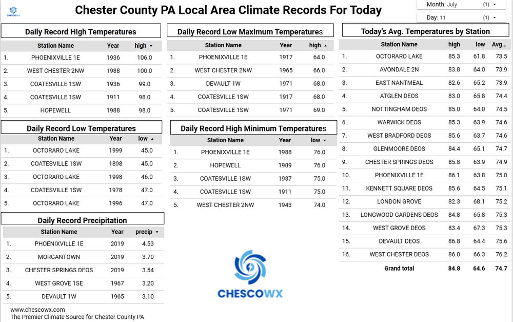
Several of our valley locations this morning saw lows down into the 50's with the ridges remaining in lower 60's. The lowest I could find was 56.3 at the Warwick DEOS. Today will be our 6th below normal temperature day over the last 8 days. We turn that around tomorrow with highs well into the 80's with 90's in the valley spots. Widespread 90's on Wednesday before we back off several degrees by Thursday. So not many spots across Chesco will get to "enjoy" the so called "heat wave" this week. By next weekend we return to near normal temperatures with increasing chances of some showers.
-
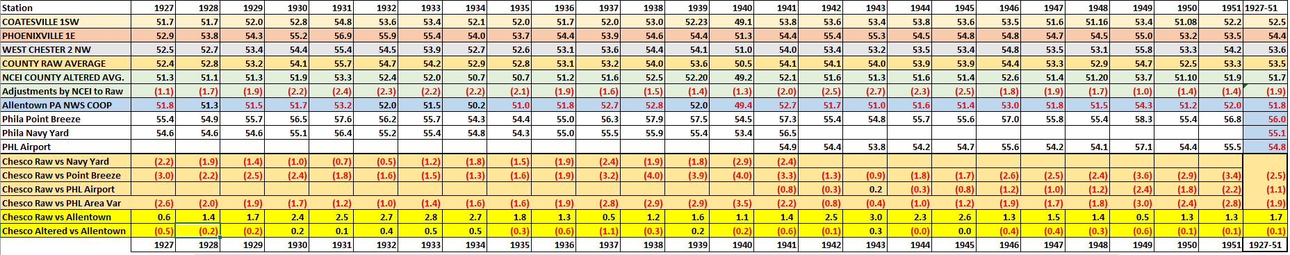
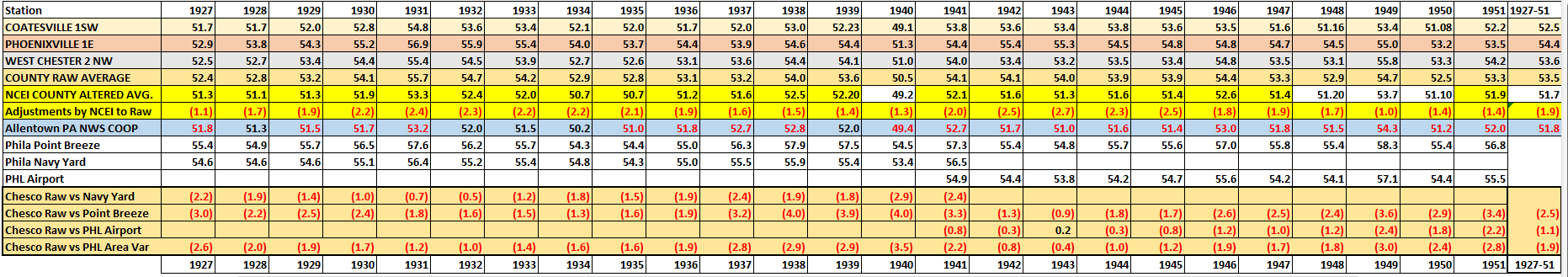
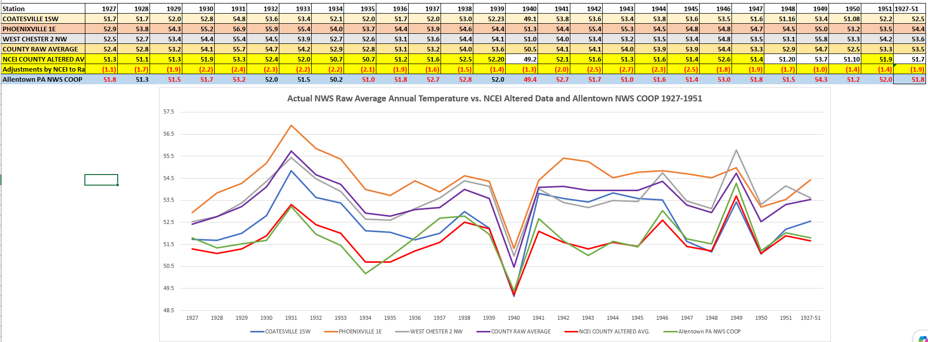
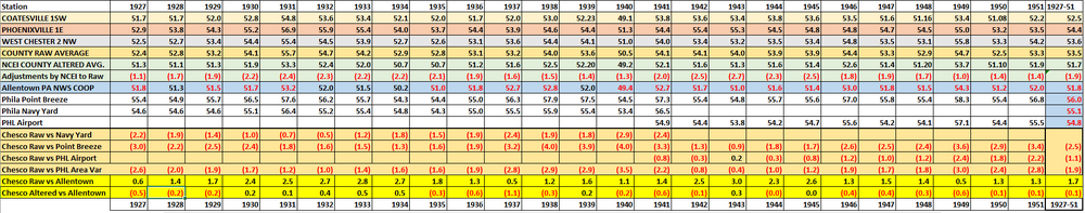
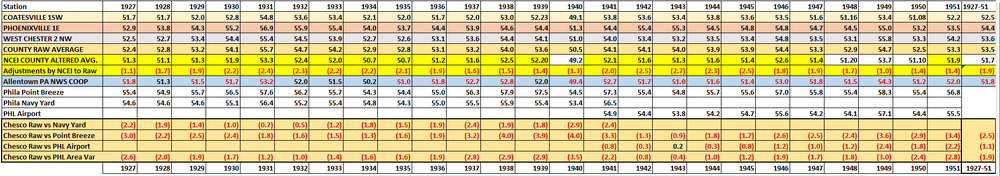
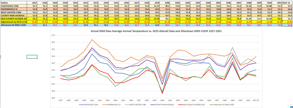
Charlie you keep avoiding my question for the years I am highlighting in the chart 1927-1951. There are 16 years before 1942. To make my question clearer I updated the chart (see below) to add the delta between Allentown and Chesco. You again never answer the question so I will ask it again later. By the way in looking at the surrounding nearby stations at the Navy Yard and Point Breeze it looks clearly like opening of the more rural location with less runways and building etc. at the new PHL Airport resulted in the new site being 1.6 degrees colder than the neighboring Navy Yard in 1941 and continued to run at least 1 degree colder than Point Breeze every year through 1951. So you have to wonder why NCEI failed to warm the new PHL airport site during those years due to the station move to a more rural/colder location? But even without the likely need to warm PHL for those years - the facts remain the same PHL was and is always warmer than average Chesco in every single year except one (1943) ! So I will try again - a simple question why is all of Chester County altered and adjusted to an average temperature for 17 years during this period to colder than Allentown PA?? This is 2 counties north and 50 miles away? Not just Coatesville Charlie - the average of all of these stations. Sorry Charlie in no world should the average temperature for those 25 years have Allentown at 51.8 and the all Chesco Avg. colder at 51.7 Why is NCEI correct based on their adjustments that Chester County should be altered and adjusted to be colder than Allentown for a quarter of a century based on these chilling alterations to the data? Can you answer that?
-
Central PA Summer 2026 Discussion/Obs Thread
ChescoWx replied to Voyager's topic in Upstate New York/Pennsylvania
A great couple of days ahead with temperatures running slightly cooler than average for the dates before a warmup gets underway on Tuesday. Some of our cooler valley spots may see low temperatures in the 50's by tomorrow morning. Our hottest day and best chance for widespread 90's across the County will be Wednesday. We cool a couple of degrees from there to close out the work week. Not much chance of any showers through at least Friday.
-
E PA/NJ/DE Summer 2026 Obs/Discussion
ChescoWx replied to PhiEaglesfan712's topic in Philadelphia Region
A great couple of days ahead with temperatures running slightly cooler than average for the dates before a warmup gets underway on Tuesday. Some of our cooler valley spots may see low temperatures in the 50's by tomorrow morning. Our hottest day and best chance for widespread 90's across the County will be Wednesday. We cool a couple of degrees from there to close out the work week. Not much chance of any showers through at least Friday.
-
Not sure where you are getting this assertion or I guess it may be a feeling... that "the average of Phoenixville, Coatesville and West Chester is as warm as PHL airport in the early 1940's. So let's as I always do go to the actual data for the Chester County stations vs the PHL Airport and the 2 stations relatively close to PHL prior to the temperature being recorded at the airport in 1941. Over the 25 years we are focusing on 1927-1951 the raw average temperature data of those 3 Chester County stations vs PHL was clearly always colder in each and every year!! So sorry Charlie the average is most certainly not as warm as PHL at all. In fact Chesco in those years is running as cold as much as 4 degree colder than the PHL stations. With during the entire period the average running between 1.1 and 2.5 degrees colder. We can now put to bed this false claim that Chesco was running as warm as the PHL airport area from 1927-1951. Of even more interest and brings additional questions is how the heck for most of those 25 years did NCEI decide that Chester County is actually colder than Allentown 50 miles north in Lehigh County??
-
I think most here have seen this article but the below peer reviewed study should calm many of the alarmist on this forum as both hot days and "heatwaves" and cold days are on the clear decline. This should continue to result in a decline in deaths due to climate impacts. https://link.springer.com/article/10.1007/s00704-026-06200-3
-
Central PA Summer 2026 Discussion/Obs Thread
ChescoWx replied to Voyager's topic in Upstate New York/Pennsylvania
Rain chances increase again later this afternoon with the best chances between 3pm to 8pm. A couple beautiful days on tap both Sunday and Monday with temperatures slightly cooler than average for mid-July. We start a solid warm up on Tuesday and may see widespread 90+ temps for one day on Wednesday. Still hot but "only" in the upper 80's both Thursday and Friday.
-
Central PA Summer 2026 Discussion/Obs Thread
ChescoWx replied to Voyager's topic in Upstate New York/Pennsylvania
I loved the unit but sadly I had 5 of them fail on me at the jersey shore - great customer service though as they replaced them every time. Finally gave up and went back to a vantage vue down the shore. I also have a poorly sited one at home in East Nantmeal it has run for 5 plus years but loses power now during cloudy winter days. -
E PA/NJ/DE Summer 2026 Obs/Discussion
ChescoWx replied to PhiEaglesfan712's topic in Philadelphia Region
Rain chances increase again later this afternoon with the best chances between 3pm to 8pm. A couple beautiful days on tap both Sunday and Monday with temperatures slightly cooler than average for mid-July. We start a solid warm up on Tuesday and may see widespread 90+ temps for one day on Wednesday. Still hot but "only" in the upper 80's both Thursday and Friday.
-
E PA/NJ/DE Summer 2026 Obs/Discussion
ChescoWx replied to PhiEaglesfan712's topic in Philadelphia Region
Nada in NW chesco too -
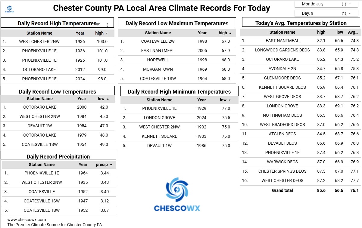
Who can spot the significant warming of the USA away from our urban heat islands?? This looks a whole lot like Chester County PA - I bet you NCEI chilled the 1920's and 1930's - I always said there is no climate fence around any county!
-
I hear this is his first stop! LOL!
-
Central PA Summer 2026 Discussion/Obs Thread
ChescoWx replied to Voyager's topic in Upstate New York/Pennsylvania
After our heavy rain across much of Southern Chester County yesterday today will feature some additional shower chances both today and tomorrow with a slow-moving cold front. High temperatures today will be near normal in the low to mid 80's. A bit below normal over the weekend before we warm to the upper 80's on Tuesday and near 90 degrees both Wednesday and Thursday.

-
E PA/NJ/DE Summer 2026 Obs/Discussion
ChescoWx replied to PhiEaglesfan712's topic in Philadelphia Region
After our heavy rain across much of Southern Chester County yesterday today will feature some additional shower chances both today and tomorrow with a slow-moving cold front. High temperatures today will be near normal in the low to mid 80's. A bit below normal over the weekend before we warm to the upper 80's on Tuesday and near 90 degrees both Wednesday and Thursday.
-
Great news for climate scientists and bad news for climate alarmists with this appointment of Dr. Weilicki to lead the U.S. Global Change Research Program!! From Secretary Chris White "Matt Weilicki is an honest scientist who follows the data wherever it leads. That is what science is all about. He will lead our efforts to honestly present the empirical climate data to guide policy makers. Sadly, too much of the mainstream climate community has focused on a scary narrative that is inconsistent with actual climate data, leading so many astray like reporters at Politico. I welcome the new era where data, not rhetoric, is the arbiter of truth. Growing the government, increasing energy prices, and scaring children will no longer be the goal. Science will be the goal. So happy to have Matt in this role!"
-
The telltale sign of having no answer to the science/data is when someone like Charlie attempts to push the falsehood of something he deems "settled science". Science is of course never settled but constantly evaluated and tested which I do constantly. There is clearly no mistake in the table as it it actual validated raw data.....the real mistake is Charlie and NCEI thinking Chester County on average is colder than Allentown. Plus Charlie I love your line "between 1927 and 1951, the County COOP stations are much warmer than the county average" Welp I included all of the COOP stations so again exactly which station? since all are included above? Also, how do you know in fact during those years the county stations were according to NCEI in reality colder than Allentown? Real science over feelings FTW!!
-
Central PA Summer 2026 Discussion/Obs Thread
ChescoWx replied to Voyager's topic in Upstate New York/Pennsylvania
The haves - Southern Chesco and have nots Northern Chesco continue with some rain totals today as of 645pm DEOS stations - Atlgen 0.93" / Longwood Gardens 1.43" / Nottingham 1.96"/ Kennett Square 2.17" / West Grove 1.28" / Atglen 0.99" / West Bradford 1.03" / West Chester 0.34" / Chester Springs 0.00" / Glenmoore 0.04" / Warwick 0.04" -
E PA/NJ/DE Summer 2026 Obs/Discussion
ChescoWx replied to PhiEaglesfan712's topic in Philadelphia Region
The haves - Southern Chesco and have nots Northern Chesco continue with some rain totals today as of 645pm DEOS stations - Atlgen 0.93" / Longwood Gardens 1.43" / Nottingham 1.96"/ Kennett Square 2.17" / West Grove 1.28" / Atglen 0.99" / West Bradford 1.03" / West Chester 0.34" / Chester Springs 0.00" / Glenmoore 0.04" / Warwick 0.04" -
Revisiting that old topic that no one seems to be able to answer - not the why they did it - but how exactly or where exactly did NCEI look for their control COOP or analog station to support their chilling adjustments of the historical raw data for Chester County PA. Again we focus on the 25 year period of greatest adjustments to the raw data from 1927-1951. I think I may have found the station they use as the adjusted NCEI data is very close to this station. However, one big problem is this station sits a couple counties and 30 plus miles north of Chester County. I looked to the NWS COOP Allentown PA site which was the Allentown Gas COOP site. This station was the primary Allentown climate station prior to ABE. Of note NCEI chose to chill Chester County to actually lower than Allentown PA in 20 of these 25 years! Keep in mind again in 20 of 25 years there is no actual NWS COOP site in the county that was as cool as the post hoc NCEI County averages. So overall NCEI believes that Chester County is colder than Allentown....
-
Central PA Summer 2026 Discussion/Obs Thread
ChescoWx replied to Voyager's topic in Upstate New York/Pennsylvania
A flood watch is in effect through midnight for the potential of some heavy rain. Some isolated spots could see the rain fall at 1" to 2" per hour. No doubt with our rain deficit let's hope we all see some beneficial rain today! Additional shower chances tomorrow before we start to clear out on Saturday. Today will be our 4th straight day with below normal temperatures this should continue through the weekend before we warm to normal on Tuesday in the mid-80's and above normal with near 90 by Wednesday. It looks like great weather for the All-Star Game in Philly next week.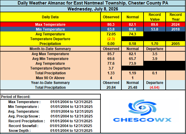

-
E PA/NJ/DE Summer 2026 Obs/Discussion
ChescoWx replied to PhiEaglesfan712's topic in Philadelphia Region
A flood watch is in effect through midnight for the potential of some heavy rain. Some isolated spots could see the rain fall at 1" to 2" per hour. No doubt with our rain deficit let's hope we all see some beneficial rain today! Additional shower chances tomorrow before we start to clear out on Saturday. Today will be our 4th straight day with below normal temperatures this should continue through the weekend before we warm to normal on Tuesday in the mid-80's and above normal with near 90 by Wednesday. It looks like great weather for the All-Star Game in Philly next week.
-
Central PA Summer 2026 Discussion/Obs Thread
ChescoWx replied to Voyager's topic in Upstate New York/Pennsylvania
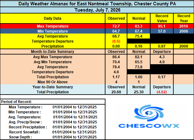
Yesterday's high here in East Nantmeal was only 72.7 this set a new low maximum temperature for the date set back in 2005 of 73.7. Another below normal temperature day today with highs not far from 80 degrees. Shower chances increase tomorrow afternoon and again on Friday into Friday night. Temperatures remain near normal through the weekend before warming a few degrees above with highs by the middle of next week in the mid to upper 80's. Does not look like any return of 90 degree plus reading across the county for the foreseeable future.