ChescoWx
-
Posts
9,570 -
Joined
-
Last visited
Content Type
Profiles
Blogs
Forums
American Weather
Media Demo
Store
Gallery
Everything posted by ChescoWx
-
Something for everyone over the next couple weeks - if you believe in Goofus...
-
With an average US Temperature now 4.1 degrees below normal this January is on pace for the coldest 1st month of the year in 37 years (1988) across the US!
-
With an average US Temperature now 4.1 degrees below normal this January is on pace for the coldest 1st month of the year in 37 years (1988) across the US!
-
Near normal temperatures to start the week rising to slightly above on Wednesday before chillier again on Thursday. Rain chances increase by Friday with some mixed wintry precipitation possible by later in the weekend.
-
Near normal temperatures to start the week rising to slightly above on Wednesday before chillier again on Thursday. Rain chances increase by Friday with some mixed wintry precipitation possible by later in the weekend.
-
Go Birds! Near normal late January temperatures today through Tuesday. We then see one above normal day on Wednesday with temps in the mid-40's before we turn back to below normal temperatures to close out the work week. The chances increase by next weekend of a wintry mix of snow to freezing rain to rain.
-
1994 while cold was far from dry with over 7" of liquid in January at Coatesville and 6" at West Chester with another 4" at Coatesville in Feb and 3" at West Chester
-
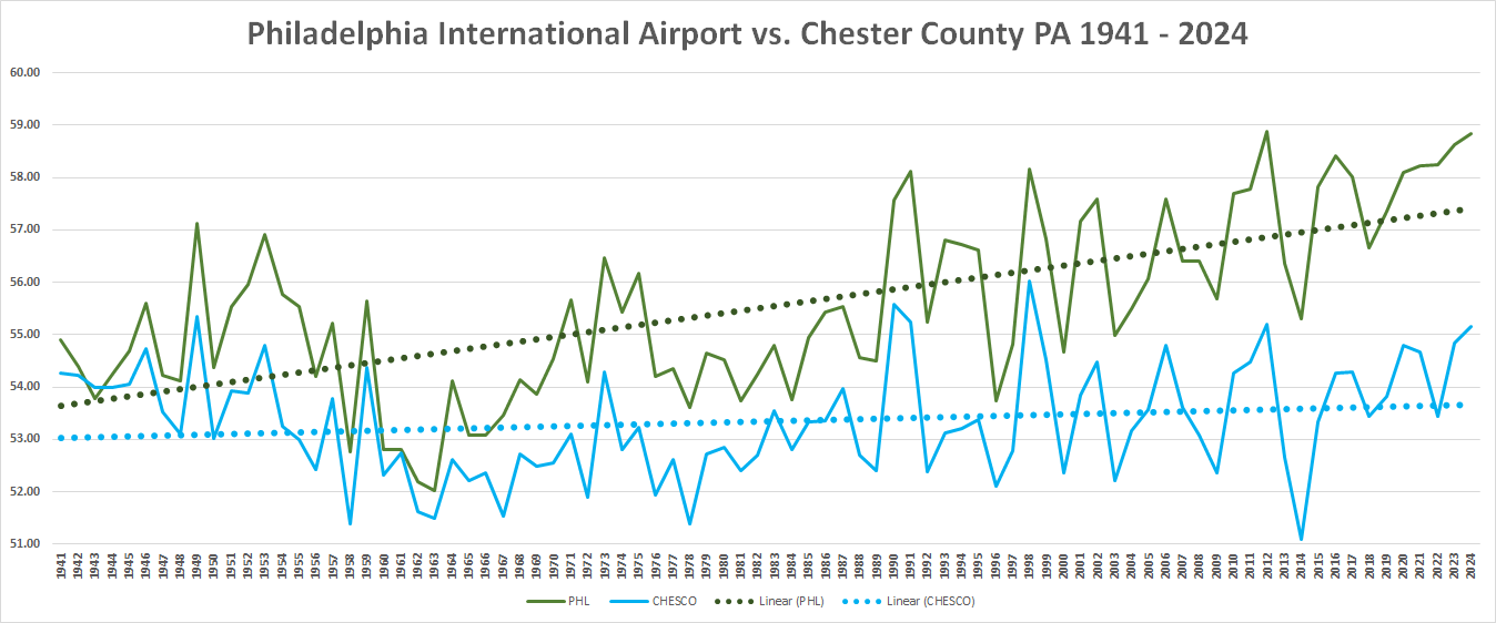
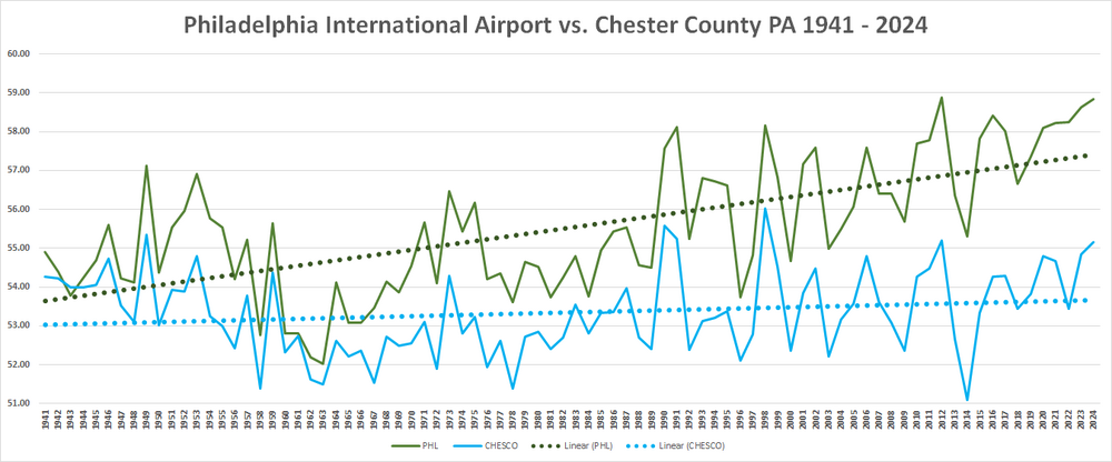
Finally got around to updating my analysis of PHL Airport average annual temperatures vs. the Chester County PA NWS COOP/AWOS and Mesonet sites for 1941 through 2024. The UHI impact at PHL becomes clearer with each passing year.
-
Finally got around to updating my analysis of PHL Airport average annual temperatures vs. the Chester County PA NWS COOP/AWOS and Mesonet sites for 1941 through 2024. The UHI impact at PHL becomes clearer with each passing year.
-
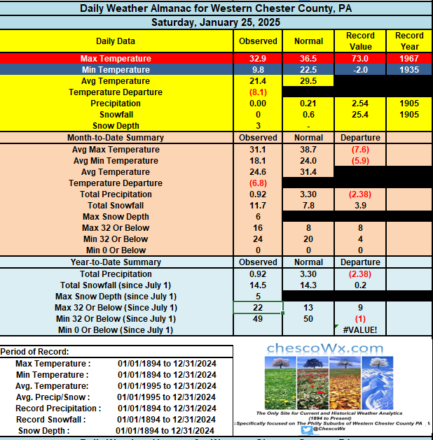
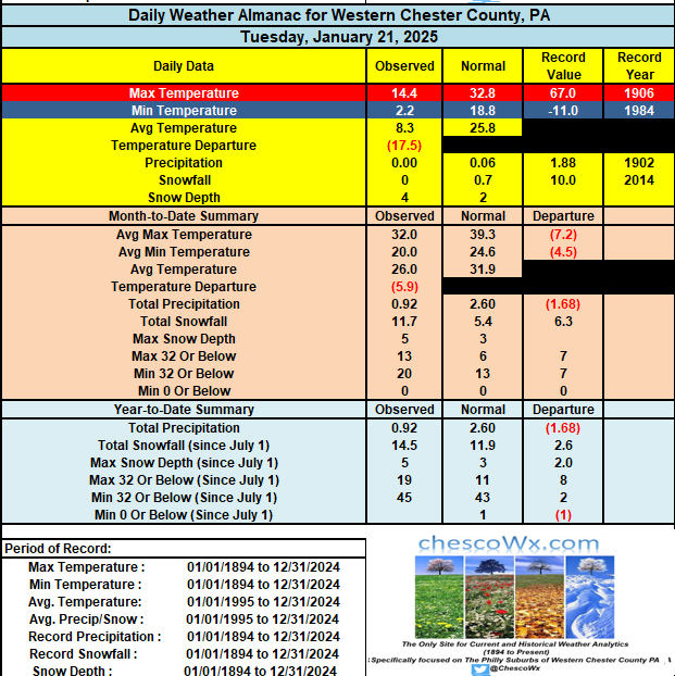
Here in Chester County PA Through yesterday 2025 is off to the coldest start in 31 years since that extremely cold January of 1994. Yet another very cold morning across the County this morning with 8 of our 18 current lower elevation station locations again reaching below zero levels. Most of these locations have had 3 such mornings in a row. We stay well below normal for the next 3 days before we warm to normal levels for late January by the end of this week and into early next week. We look to stay dry for at least the next week.
-
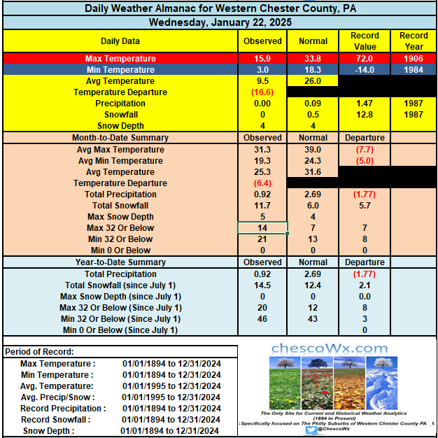
This morning was one of Chester County's coldest mornings in the last 31 years dating back to January 19, 1994. There were 7 stations this morning that recorded below zero readings. This includes 9.1 below zero at Warwick Township (station record 14 years of data) this was the coldest station reading in Chester County since the 11 below zero reading at Coatesville 2W in 1994. That day the 19th was also the only day in County history a station failed to get above zero for a high temperature. West Bradford / Marshallton also set a station record of 4.7 below zero breaking the old station record of 3.8 degrees below back on January 14, 2014. If you think we have had a long stretch of below normal cold you would be correct! Since Thanksgiving Day, we have seen below normal temperatures on 70% of 39 of those 56 days. This includes 25 of the past 33 days. The good news is we should finally see a return to near normal average temperatures by Sunday into early next week. We also look to stay dry for most of the next week. Stay warm!
-
Euro has "measurable" for some this evening....
-
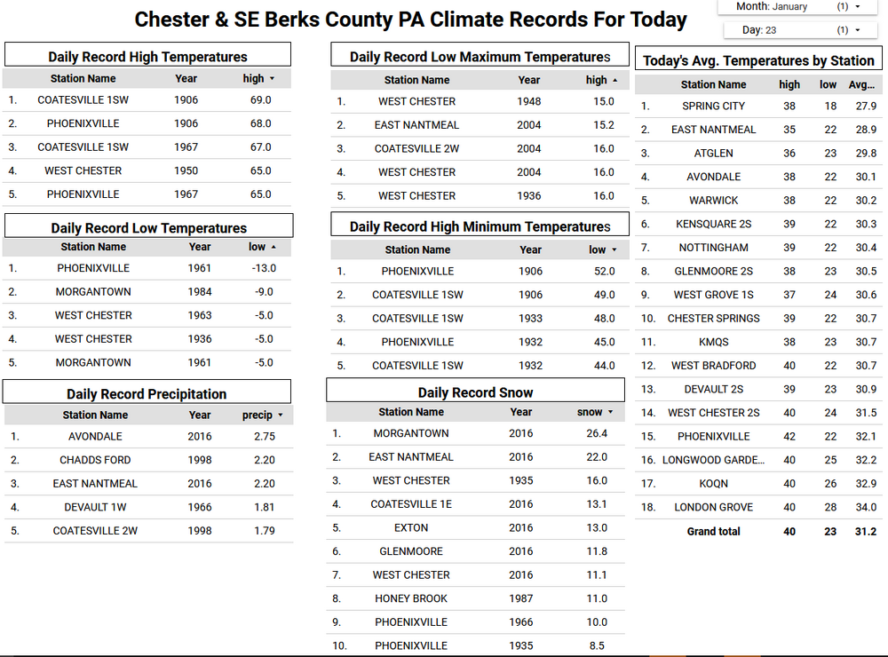
Most locations across Chester County experienced our coldest morning since January 31, 2019. Multiple stations fell to below zero with 2 stations Warwick Township 6.5 below zero and Devault 2.7 below setting all-time station low temperature records with NWS Mesonet data back to 2012. Other locations with sub-zero lows included Chester Springs 3.4 below (2nd coldest ever), West Bradford Township 3.5 below and West Chester 1.1 below. The warmest spot as always was the Brandywine West Chester Airport with a low of only 6.8 above. Our very cold weather continues all week before me finally moderate to above freezing by Sunday. Our next snow chance looks to be toward next Monday.

-
Most locations across Chester County experienced our coldest morning since January 31, 2019. Multiple stations fell to below zero with 2 stations Warwick Township 6.5 below zero and Devault 2.7 below setting all-time station low temperature records with NWS Mesonet data back to 2012. Other locations with sub-zero lows included Chester Springs 3.4 below (2nd coldest ever), West Bradford Township 3.5 below and West Chester 1.1 below. The warmest spot as always was the Brandywine West Chester Airport with a low of only 6.8 above. Our very cold weather continues all week before me finally moderate to above freezing by Sunday. Our next snow chance looks to be toward next Monday.
-
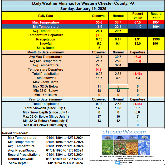
With yesterday's snow which totaled 5.3" (w.e. 0.43") we are now up to 11.7" for the month of January through yesterday. This is 7.4" above our normal snow to date. For the winter season we stand at 14.5" of snow which is 3.7" above normal through yesterday. There is a cold weather advisory in effect through noon on Wednesday. Temperatures today will struggle to reach 20 degrees - while tomorrow and Wednesday will see highs in the mid-teens. Low temperatures the next 3 nights will be within a few degrees of zero. We start a slow moderating trend on Friday and may finally see temperatures rise to above freezing by next Sunday.
-

1/19/25 Eagles Playoff Winter Storm obs
ChescoWx replied to Ralph Wiggum's topic in Philadelphia Region
5.0" of snow so far still light snow here in East Nantmeal. Temp 22.2. Month to date 11.4" of snow +7.1" above normal to date. Season to date 14.2" which is 3.4" above normal. -
As of 830pm 5.0" of snow at East Nantmeal Township Chester County PA
-
As of 7pm 4.3" if snow here in East Nantmeal....moderate snow still falling and 23.3 degrees,,,,,we are now at 13.5" of snow this season which is 25% above our normal snow through today!
-
1/19/25 Eagles Playoff Winter Storm obs
ChescoWx replied to Ralph Wiggum's topic in Philadelphia Region
As of 7pm 4.3" if snow here in East Nantmeal....moderate snow still falling and 23.3 degrees,,,,,we are now at 13.5" of snow this season which is 25% above our normal snow through today! -
1/19/25 Eagles Playoff Winter Storm obs
ChescoWx replied to Ralph Wiggum's topic in Philadelphia Region
4.3" so far here in East Nantmeal still moderate snow and 23.7 degrees -
1/19/25 Eagles Playoff Winter Storm obs
ChescoWx replied to Ralph Wiggum's topic in Philadelphia Region
S+ again here in NW chesco might make low end of 4" snowfall!