

ChescoWx
-
Posts
9,208 -
Joined
-
Last visited
Content Type
Profiles
Blogs
Forums
American Weather
Media Demo
Store
Gallery
Everything posted by ChescoWx
-

1/6 snowstorm - nuisance event or something bigger?
ChescoWx replied to LVblizzard's topic in Philadelphia Region
-
1/6 snowstorm - nuisance event or something bigger?
ChescoWx replied to LVblizzard's topic in Philadelphia Region
-
January 3, 2025 Light Snow Event Observations
ChescoWx replied to ChescoWx's topic in Philadelphia Region
As of 5pm I just reported 0.5" to the NWS for East Nantmeal. This brings our seasonal total to 3.3" which is about 50% of average. May see a little more if any of those bands over Central PA hold together. -
1/6 snowstorm - nuisance event or something bigger?
ChescoWx replied to LVblizzard's topic in Philadelphia Region
Quite the cut off on the NAM 4" at KPTW to 11" at KMQS -
January 3, 2025 Light Snow Event Observations
ChescoWx replied to ChescoWx's topic in Philadelphia Region
Some steadier light snow here in EN temp down to 30.2 -
January 3, 2025 Light Snow Event Observations
ChescoWx replied to ChescoWx's topic in Philadelphia Region
Light Snow down to 31.5 degrees here in East Nantmeal -
Some very light snow has started here in East Nantmeal Twp. in Chester County Temp 32.2
-
1/6 snowstorm - nuisance event or something bigger?
ChescoWx replied to LVblizzard's topic in Philadelphia Region
After our next 2 events (today and Monday) - Expect another storm to track for next weekend. -
1/6 snowstorm - nuisance event or something bigger?
ChescoWx replied to LVblizzard's topic in Philadelphia Region
-
1/6 snowstorm - nuisance event or something bigger?
ChescoWx replied to LVblizzard's topic in Philadelphia Region
Latest HRRR for this PM tries to bring a couple inches to some.... -
1/6 snowstorm - nuisance event or something bigger?
ChescoWx replied to LVblizzard's topic in Philadelphia Region
-
1/6 snowstorm - nuisance event or something bigger?
ChescoWx replied to LVblizzard's topic in Philadelphia Region
For those anxiously awaiting the WXSIM snow forecasts for EN....the wait is over! WXSIM now mixes the GFS EURO and NAM to make it's forecast. WXSIM text forecast for East Nantmeal, initialized at 9:00 AM Jan 3, 2025 _______________________________________________________________________________ Today: Partly to mostly cloudy in the morning, becoming mostly cloudy to cloudy in the afternoon. High 34. Wind chill around 26. Wind west around 5 mph. Tonight: Mostly cloudy in the evening, becoming fair to partly cloudy after midnight. A chance of snow. Low 25. Wind chill ranging from 16 to 27. Wind west-northwest around 5 mph in the evening, becoming 9 mph, gusting to 17 mph, after midnight. Chance of precipitation 30 percent. Precipitation (liquid equivalent) mostly less than a tenth of an inch. Snow accumulation about a quarter inch. Monday: Dense overcast. Patchy light fog in the afternoon. Snow likely. High 29. Wind northwest around 3 mph in the morning, becoming northeast in the afternoon. Chance of precipitation 70 percent. Precipitation (liquid equivalent) mostly around a quarter of an inch. Snow accumulation 2 to 3 inches. Monday night: Cloudy in the evening, becoming mostly cloudy after midnight, with areas of light frost likely. Patchy light fog in the evening. Snow likely. Low 25. Wind chill ranging from 15 to 20. Wind north around 8 mph, gusting to 17 mph, in the evening, becoming 12 mph, gusting to 22 mph, after midnight. Chance of precipitation 70 percent. Precipitation (liquid equivalent) mostly around a quarter of an inch. Snow accumulation around 2 inches. -
Light snow should arrive from west to east across Chester and Berks counties during the 2pm hour this afternoon. The timing is not great as the steadiest snow will fall during rush hour. There should be at most an inch or so over the area. We turn colder this weekend with temperatures remaining below freezing for at least the next week. The next winter event looks like it will arrive overnight Sunday into Monday morning. Most of the ensemble models keep the more significant snow south of the Mason Dixon Line. That said most areas will see at least a couple inches with more as you go south in Chester County toward Maryland.
-
1/6 snowstorm - nuisance event or something bigger?
ChescoWx replied to LVblizzard's topic in Philadelphia Region
Agreed Steve I suspect from the PA Turnpike south to MD border is a solid 2" to 4" with an inch or 2 up to the ABE area. But a sharp cutoff to the northeast of there... -
1/6 snowstorm - nuisance event or something bigger?
ChescoWx replied to LVblizzard's topic in Philadelphia Region
The 12km NAM at the end of it's range looks to be a bit further north with it's model snow.... -
1/6 snowstorm - nuisance event or something bigger?
ChescoWx replied to LVblizzard's topic in Philadelphia Region
Welp at least the ICON is a bit further north....if we are looking for the snowier solutions.....the trend on the ensembles is telling IMHO -
1/6 snowstorm - nuisance event or something bigger?
ChescoWx replied to LVblizzard's topic in Philadelphia Region
Canadian with a move south with heaviest totals from 12z and sharper cutoff to the NE than earlier run -
Tomorrow night's event - this is only out to 10pm tomorrow
-
There is no right or wrong but in most situations I have found the K method is usually at least an improvement over 10:1
-
I do think with colder storms the Kutchera does a better job with the ratios but it is not available on the ensemble runs....the ensemble did move a bit north again from the 12z run
-
-
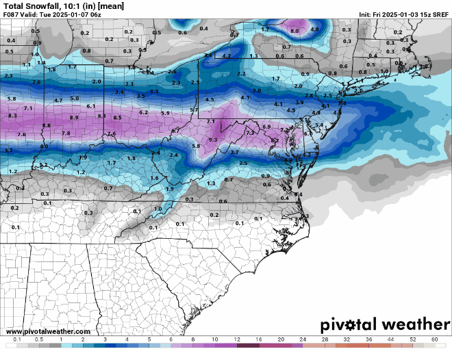
Double digits for NW Chesco......if you choose to believe in model snow!!
-
It was February 13th 10.5" at East Nantmeal / 9.3" West Caln and up in Berks County at Huff's Church 9.4"
-
The HRRR radar depicts the snow starting by 2pm across Chesco with the heaviest (see below) at about 5pm.....not a great scenario for rush hour travel if this comes to pass!

