ChescoWx
-
Posts
9,338 -
Joined
-
Last visited
Content Type
Profiles
Blogs
Forums
American Weather
Media Demo
Store
Gallery
Everything posted by ChescoWx
-
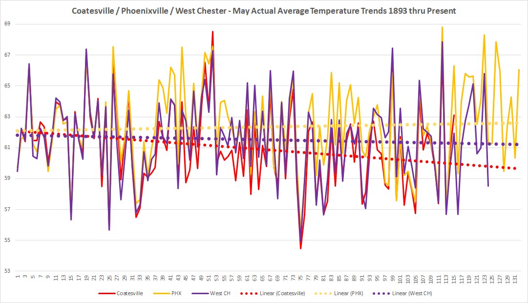
 As we head toward May will our historical cooling trend continue? Below is the 3 longest running Chester County NWS Locations for May since 1893
-
But of course Charlie they do!! See below both Coatesville and West Chester show clear cooling while Phoenixville shows only very slight warming....actual facts vs. altered alternative facts!!!! The majority of stations with long term data are indeed cooling during May in Chester County PA!!

-
We have experienced below normal temperatures for 11 of the first 16 days here in April. Today while milder it will still be below normal with our highs near 60 degrees. We finally see a couple warmer days starting tomorrow with highs near 70 and even warmer Saturday with temperatures approaching 80 degrees. About 10 degrees cooler on Easter Sunday but still a few degrees above normal.


-
E PA/NJ/DE Spring 2025 Obs/Discussion
ChescoWx replied to PhiEaglesfan712's topic in Philadelphia Region
We have experienced below normal temperatures for 11 of the first 16 days here in April. Today while milder it will still be below normal with our highs near 60 degrees. We finally see a couple warmer days starting tomorrow with highs near 70 and even warmer Saturday with temperatures approaching 80 degrees. About 10 degrees cooler on Easter Sunday but still a few degrees above normal.
-
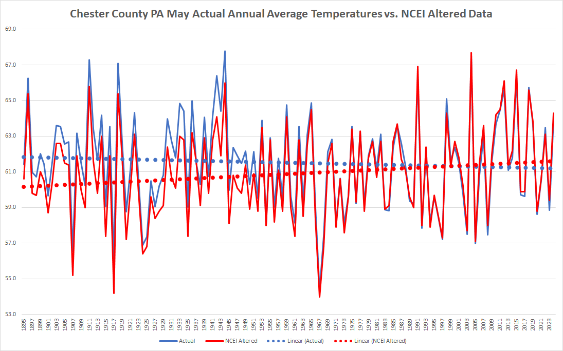
Charlie fortunately we have the actual data for ALL of the stations not just West Chester and Coatesville. As we can all see clearly below without the post hoc adjustments to chill the past and warm the present (see how the lines cross in the early 90's) we clearly see the actual raw data for May (blue) is cooling while only the altered (blue) artificial data indicates warming.

-
A cold front will cross the area this morning with a shower in some spots this afternoon. Turning much chillier tonight and tomorrow with high temperatures tomorrow near 15 degrees below normal with temperatures remaining in the 40's. A warming trend starts on Thursday with the warmest day being Saturday with highs well into the 70's. We could see some showers Saturday before cooler again by Easter Sunday.


-
E PA/NJ/DE Spring 2025 Obs/Discussion
ChescoWx replied to PhiEaglesfan712's topic in Philadelphia Region
A cold front will cross the area this morning with a shower in some spots this afternoon. Turning much chillier tonight and tomorrow with high temperatures tomorrow near 15 degrees below normal with temperatures remaining in the 40's. A warming trend starts on Thursday with the warmest day being Saturday with highs well into the 70's. We could see some showers Saturday before cooler again by Easter Sunday.
-
A couple of light showers are crossing the area this morning. A cloudy day today with high temperatures just a couple of degrees below normal in the low 60's. Chiller again tonight through Thursday before a warming trend bets underway on Friday before we turn a bit cooler than normal again by Easter Sunday. Some shower chances both overnight tonight and again Saturday night.


-
E PA/NJ/DE Spring 2025 Obs/Discussion
ChescoWx replied to PhiEaglesfan712's topic in Philadelphia Region
A couple of light showers are crossing the area this morning. A cloudy day today with high temperatures just a couple of degrees below normal in the low 60's. Chiller again tonight through Thursday before a warming trend bets underway on Friday before we turn a bit cooler than normal again by Easter Sunday. Some shower chances both overnight tonight and again Saturday night.
-
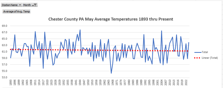
The Actual Data taken within the County before alteration and adjustments says we have far from warmed significantly in any of those months....and have in fact cooled in May
-
The sun returns today, and we start a slow warming trend although temperatures will remain below normal through the upcoming work week. By Friday we should see temperatures near normal with finally some above normal days by Easter Weekend. The only rain chances look to be Monday night into Tuesday morning.


-
E PA/NJ/DE Spring 2025 Obs/Discussion
ChescoWx replied to PhiEaglesfan712's topic in Philadelphia Region
The sun returns today, and we start a slow warming trend although temperatures will remain below normal through the upcoming work week. By Friday we should see temperatures near normal with finally some above normal days by Easter Weekend. The only rain chances look to be Monday night into Tuesday morning.
-
E PA/NJ/DE Spring 2025 Obs/Discussion
ChescoWx replied to PhiEaglesfan712's topic in Philadelphia Region
Some area snowfall reports around the area from the NWS this morning. ...Berks County... Huffs Church 2.5 in 0726 AM 04/12 Trained Spotter Alburtis 4.7 SW 2.3 in 0700 AM 04/12 COCORAHS Lyons 2.6 SE 2.0 in 0700 AM 04/12 COCORAHS Fleetwood 2 ESE 1.3 in 0700 AM 04/12 COCORAHS Mohnton 2.8 SSW 0.7 in 0800 AM 04/12 COCORAHS Fleetwood 4.8 ESE 0.5 in 0700 AM 04/12 COCORAHS Morgantown 0.5 in 0730 AM 04/12 Public ...Bucks County... 1.2 NE Springtown 0.3 in 0710 AM 04/12 COOP ...Carbon County... Lake Harmony 2.4 WNW 3.2 in 0700 AM 04/12 COCORAHS ...Chester County... East Nantmeal 1.0 SSW 0.3 in 0930 AM 04/12 COCORAHS ...Lehigh County... Salisbury Twp 1.4 in 0830 AM 04/12 Trained Spotter Washington Twp 0.5 in 0848 AM 04/12 Trained Spotter -
So far this April we are running 2 degrees below average temperatures for the month. So far for the year to date through yesterday we are running 0.5 degrees below normal in temperatures. If April finishes with below normal temperatures this will mark the 4th month out of the last 5 months with the exception of March that have finished below average. The next week looks to continue our run of below normal temperatures with the warmest day of the week in the lower 60's on Monday, which is not too far from our typical mid-April highs. With the rain and melted snow since yesterday we continue to take a serious bite out of any drought concerns as we are now up to 86% of normal precipitation so far this year which is only 1.83" below normal today. Our next chance of rain looks to arrive by Monday night.


-
E PA/NJ/DE Spring 2025 Obs/Discussion
ChescoWx replied to PhiEaglesfan712's topic in Philadelphia Region
So far this April we are running 2 degrees below average temperatures for the month. So far for the year to date through yesterday we are running 0.5 degrees below normal in temperatures. If April finishes with below normal temperatures this will mark the 4th month out of the last 5 months with the exception of March that have finished below average. The next week looks to continue our run of below normal temperatures with the warmest day of the week in the lower 60's on Monday, which is not too far from our typical mid-April highs. With the rain and melted snow since yesterday we continue to take a serious bite out of any drought concerns as we are now up to 86% of normal precipitation so far this year which is only 1.83" below normal today. Our next chance of rain looks to arrive by Monday night.
-
We received 1.32" of rain and melted snow. We ended up with 0.3" of snow this is the 7th time in the 22 years we have recorded measurable snow in April here in East Nantmeal The last time it snowed in April was back on April 2, 2018 the 2.5” of snow that fell that day was the most daily snow I have recorded here in EN. This is the 2nd latest measurable snow in a season behind only the 2.0" of snow that fell here on April 16, 2007. This brings our seasonal snow total up to 21.5" which is 61% of our average EN season snow total of 35.1"
-
E PA/NJ/DE Spring 2025 Obs/Discussion
ChescoWx replied to PhiEaglesfan712's topic in Philadelphia Region
We received 1.32" of rain and melted snow. We ended up with 0.3" of snow this is the 7th time in the 22 years we have recorded measurable snow in April here in East Nantmeal The last time it snowed in April was back on April 2, 2018 the 2.5” of snow that fell that day was the most daily snow I have recorded here in EN. This is the 2nd latest measurable snow in a season behind only the 2.0" of snow that fell here on April 16, 2007. This brings our seasonal snow total up to 21.5" which is 61% of our average EN season snow total of 35.1" -
E PA/NJ/DE Spring 2025 Obs/Discussion
ChescoWx replied to PhiEaglesfan712's topic in Philadelphia Region
Snowing steadily here in NW Chesco temp down to 33.8 degrees -
E PA/NJ/DE Spring 2025 Obs/Discussion
ChescoWx replied to PhiEaglesfan712's topic in Philadelphia Region
Last time we had a major April Snowstorm (not that IF we see any snow tonight it will be major) was back on March 31 - April 1, 1997. Heavy rain and mild temps gave way to heavy elevation driven snow. Some area totals Coatesville 13.7" Hopewell 10.3" Glenmoore 12.0" -
E PA/NJ/DE Spring 2025 Obs/Discussion
ChescoWx replied to PhiEaglesfan712's topic in Philadelphia Region
East Nantmeal recorded 2.5" on that day -
E PA/NJ/DE Spring 2025 Obs/Discussion
ChescoWx replied to PhiEaglesfan712's topic in Philadelphia Region
Latest HRRR shows elevation driven wet snow tonight across the higher spots over 500 ft ASL across the area....especially the highest spots over 650 ft across NW Chester / SE Berks and Northern Bucks/Montgo.
-
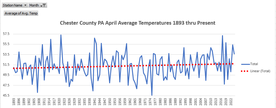
March - April - May Average Temperature Trends Raw Unaltered Data 1893 to Present - Near steady March and slight warming April with cooling in May.....

-
Of course still no answer for chilling to levels going below any actual real observations across the entire County.....Not one station was accurate for up to 100 years? So after the fact we chill every single one of them??
-
So far overnight we have received 0.06" of rain here in East Nantmeal. Our below normal temperature pattern looks to continue for much of at least the next week with only Monday looking to approach near normal high temperatures for mid-April. Rain showers this morning will become steadier and heavier tonight through tomorrow morning before tapering off to showers later Saturday. Rainfall amounts look to be between 1.0" to 1.5" for much of the area.


-
E PA/NJ/DE Spring 2025 Obs/Discussion
ChescoWx replied to PhiEaglesfan712's topic in Philadelphia Region
So far overnight we have received 0.06" of rain here in East Nantmeal. Our below normal temperature pattern looks to continue for much of at least the next week with only Monday looking to approach near normal high temperatures for mid-April. Rain showers this morning will become steadier and heavier tonight through tomorrow morning before tapering off to showers later Saturday. Rainfall amounts look to be between 1.0" to 1.5" for much of the area.