north pgh
-
Posts
2,957 -
Joined
-
Last visited
Content Type
Profiles
Blogs
Forums
American Weather
Media Demo
Store
Gallery
Everything posted by north pgh
-

Western Pa / Pittsburgh area Winter Discussion ❄️☃️
north pgh replied to north pgh's topic in Upstate New York/Pennsylvania
Snow falling here early and coming down pretty good. -
Western Pa / Pittsburgh area Winter Discussion ❄️☃️
north pgh replied to north pgh's topic in Upstate New York/Pennsylvania
Not me. I will enjoy them all. I am one to enjoy a 2-4 clipper any day. And you can shovel a little at a time. -
Western Pa / Pittsburgh area Winter Discussion ❄️☃️
north pgh replied to north pgh's topic in Upstate New York/Pennsylvania
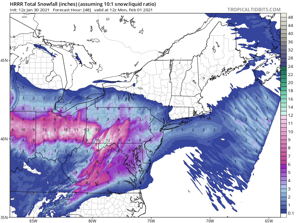
,This is the NAM for this evenings snow and the midweek snow. Cut these totals in half and I will take it but the way this winter is going I could see us maxing out on the higher totals. A fun week nevertheless. 3 potential storms.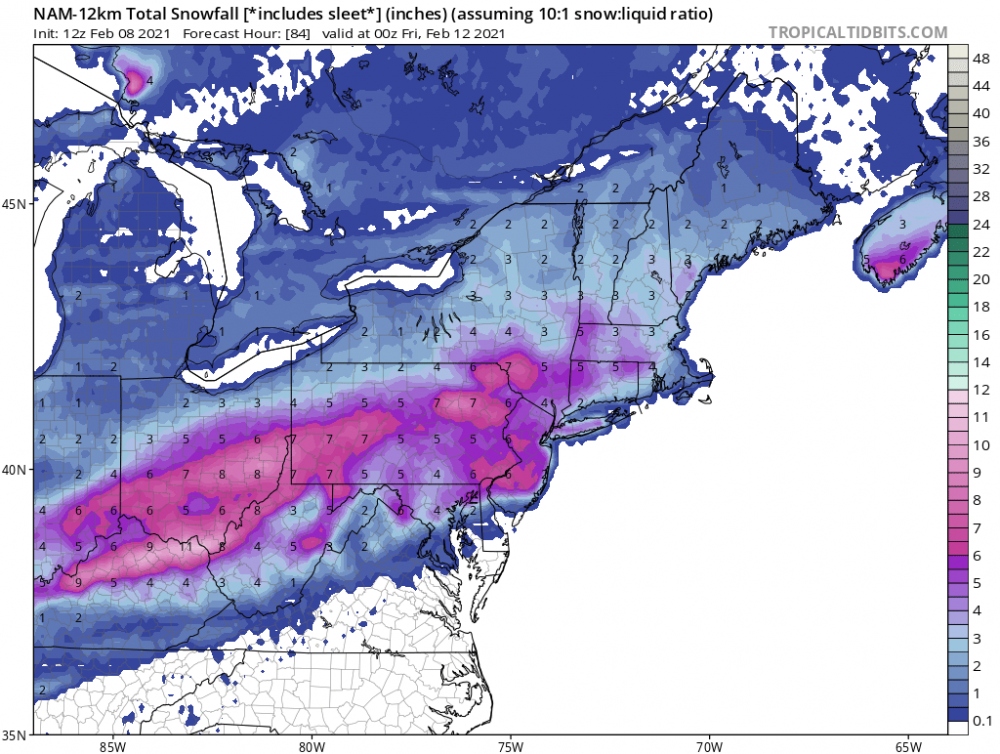
-
Western Pa / Pittsburgh area Winter Discussion ❄️☃️
north pgh replied to north pgh's topic in Upstate New York/Pennsylvania
I just happened to look outside and getting some intense snow bands and wind. -
Western Pa / Pittsburgh area Winter Discussion ❄️☃️
north pgh replied to north pgh's topic in Upstate New York/Pennsylvania
As of now 18HRRR shows us getting about 2 inches of snow tomorrow night. -
Western Pa / Pittsburgh area Winter Discussion ❄️☃️
north pgh replied to north pgh's topic in Upstate New York/Pennsylvania
Hey time to move forward. Picked up an inch today. Snow is starting to pick up slowly. Let’s enjoy our 4-6 from tonight thru Tuesday am. -
Western Pa / Pittsburgh area Winter Discussion ❄️☃️
north pgh replied to north pgh's topic in Upstate New York/Pennsylvania
I think we are fine. No models show the rain snow line coming any further north. -
Western Pa / Pittsburgh area Winter Discussion ❄️☃️
north pgh replied to north pgh's topic in Upstate New York/Pennsylvania
I agree. Models only showed us getting 1 or 2 inches into early today. Look for heavier rates this afternoon. Have faith. -
Western Pa / Pittsburgh area Winter Discussion ❄️☃️
north pgh replied to north pgh's topic in Upstate New York/Pennsylvania
I’m going 6-10 and I will be happy with it. Who knows maybe it will over perform again. -
Western Pa / Pittsburgh area Winter Discussion ❄️☃️
north pgh replied to north pgh's topic in Upstate New York/Pennsylvania
HRRR still holding strong.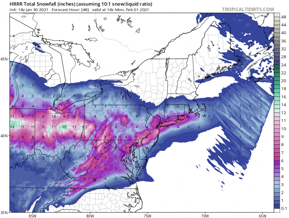
-
Western Pa / Pittsburgh area Winter Discussion ❄️☃️
north pgh replied to north pgh's topic in Upstate New York/Pennsylvania
For what’s its worth the HRRR is great
-
Western Pa / Pittsburgh area Winter Discussion ❄️☃️
north pgh replied to north pgh's topic in Upstate New York/Pennsylvania
Canadian still looks like a solid 5 inches with mix staying south. -
Western Pa / Pittsburgh area Winter Discussion ❄️☃️
north pgh replied to north pgh's topic in Upstate New York/Pennsylvania
0Z Gfs gives central Ohio 2 inches. 0Z NAM gives same area 15 inches. Something’s gotta give. -
Western Pa / Pittsburgh area Winter Discussion ❄️☃️
north pgh replied to north pgh's topic in Upstate New York/Pennsylvania
My local forecast looks to be going strictly by the GFS. Detailed Forecast This Afternoon A chance of snow showers. Cloudy, with a high near 26. Northwest wind around 14 mph. Chance of precipitation is 50%. Total daytime snow accumulation of less than a half inch possible. Tonight A chance of snow showers, mainly between 1am and 4am. Mostly cloudy, with a low around 19. Northwest wind around 10 mph. Chance of precipitation is 40%. New snow accumulation of less than a half inch possible. Friday A slight chance of snow showers before 10am. Partly sunny, with a high near 26. Northwest wind 10 to 13 mph. Chance of precipitation is 20%. Friday Night Partly cloudy, with a low around 17. Northwest wind 3 to 7 mph. Saturday Mostly sunny, with a high near 32. Calm wind becoming east around 5 mph in the afternoon. Saturday Night Snow showers likely, mainly after 2am. Cloudy, with a low around 26. Chance of precipitation is 60%. Sunday Snow before 10am, then snow and freezing rain between 10am and 2pm, then rain and snow after 2pm. High near 35. Chance of precipitation is 90%. Sunday Night Rain and snow before 3am, then snow and freezing rain likely. Low around 30. Chance of precipitation is 80%. Monday Snow and freezing rain likely before 2pm, then rain and snow likely between 2pm and 3pm, then a chance of snow after 3pm. Cloudy, with a high near 34. Chance of precipitation is 70%. Monday Night A chance of snow showers before 2am. Cloudy, with a low around 25. Chance of precipitation is 40%. -
Western Pa / Pittsburgh area Winter Discussion ❄️☃️
north pgh replied to north pgh's topic in Upstate New York/Pennsylvania
Canadian still seems to be a monster for us. -
Western Pa / Pittsburgh area Winter Discussion ❄️☃️
north pgh replied to north pgh's topic in Upstate New York/Pennsylvania
Anyway if we get 48 straight hours or so of snow at varying rates, 6-12 inches would not be out of the question. -
Western Pa / Pittsburgh area Winter Discussion ❄️☃️
north pgh replied to north pgh's topic in Upstate New York/Pennsylvania
Another over performer -
Western Pa / Pittsburgh area Winter Discussion ❄️☃️
north pgh replied to north pgh's topic in Upstate New York/Pennsylvania
One thing that I have noticed is in past years, we were always in good shape early in the models and then they trended badly for us as the event nears. This year they have been trending in the right direction. Let’s hope this weekend storm keeps trending our way. -
Western Pa / Pittsburgh area Winter Discussion ❄️☃️
north pgh replied to north pgh's topic in Upstate New York/Pennsylvania
It's funny all the changes in the models day to day. Yesterday the GFS was a bad run for us and the Canadian was great. Today the GFS us great and the Canadian is bad. Let's bring them together and give us an 8 plus snowstorm. -
Western Pa / Pittsburgh area Winter Discussion ❄️☃️
north pgh replied to north pgh's topic in Upstate New York/Pennsylvania
Beautiful snow falling now. No wind and flakes quarters and silver dollars I took the dog for a walk in it. Can’t beat it. This weekend reminded me of snowfalls growing up where not a big storm but it really hasn’t stopped snowing and we had that really heavy burst yesterday. -
Western Pa / Pittsburgh area Winter Discussion ❄️☃️
north pgh replied to north pgh's topic in Upstate New York/Pennsylvania
I nice squall line about to move in. -
Western Pa / Pittsburgh area Winter Discussion ❄️☃️
north pgh replied to north pgh's topic in Upstate New York/Pennsylvania
We just had a heavy squall cover everything with about 1/2 inch in about 20 minutes. Completely stopped now. Beautiful bands setting up. -
Western Pa / Pittsburgh area Winter Discussion ❄️☃️
north pgh replied to north pgh's topic in Upstate New York/Pennsylvania
Yes in addition to this nice surprise quick thump the models are picking up events in the next couple weeks. Looking good i picked up a solid 2 inches in 1 hour. -
Western Pa / Pittsburgh area Winter Discussion ❄️☃️
north pgh replied to north pgh's topic in Upstate New York/Pennsylvania
Yes it has been a boring couple of weeks with no precip. At least this weekend we should have some snow showers in the air. Next couple weeks hopefully we can start tracking again. -
Western Pa / Pittsburgh area Winter Discussion ❄️☃️
north pgh replied to north pgh's topic in Upstate New York/Pennsylvania
Yes the bitter cold keeps coming down and then retreating but models are now starting to get more stormy. We may have some good storms to track because the cold will pretty much be and place and reinforcing itself after each storm goes by. It looks like Minnesota may have several weeks below zero or close to it second half of January. I have to remember that the last couple of years the models aren't very reliable after 5 days and will go back and forth with storm and no storm. I think we will have things to track starting next week.