

north pgh
-
Posts
2,957 -
Joined
-
Last visited
Content Type
Profiles
Blogs
Forums
American Weather
Media Demo
Store
Gallery
Everything posted by north pgh
-
 Every station in Ohio is reporting snow. Why can’t this slide a little East so we don’t get rain. ASUS41 KCLE 221600 RWRCLE OHIO REGIONAL WEATHER ROUNDUP NATIONAL WEATHER SERVICE WILMINGTON, OH 1100 AM EST SUN JAN 22 2023 NOTE: "FAIR" INDICATES FEW OR NO CLOUDS BELOW 12,000 FEET WITH NO SIGNIFICANT WEATHER AND/OR OBSTRUCTIONS TO VISIBILITY. OHZ001>008-015>018-024>027-034-035-043-044-221700- NORTHWEST OHIO CITY SKY/WX TMP DP RH WIND PRES REMARKS DEFIANCE LGT SNOW 31 28 89 E5 29.89F FOG WCI 26 FINDLAY LGT SNOW 32 29 88 SE8 29.88S FOG WCI 25 TOLEDO EXPRESS LGT SNOW 32 29 88 E6 29.89F VSB 1 WCI 26 TOLEDO EXEC LGT SNOW 32 29 88 SE5 29.92S VSB 1 WCI 27 LIMA LGT SNOW 31 28 89 E8 29.85F FOG WCI 23 $$ OHZ009>014-019>023-028>033-038-089-221700- NORTHEAST OHIO CITY SKY/WX TMP DP RH WIND PRES REMARKS CLE-HOPKINS SNOW 31 28 89 E3 29.89F VSB 1/4 CLE-LAKEFRONT SNOW 32 30 92 E5 29.91F VSB 1/4 WCI 27 CUY CO. ARPT HVY SNOW 30 27 86 CALM 29.92R VSB 1/4 LORAIN-ELYRIA SNOW 31 28 89 SE6 29.91F VSB 1/2 WCI 25 ASHTABULA NOT AVBL AKRON-CANTON FLURRIES 33 25 72 NE3 29.88S WOOSTER LGT SNOW 28 28 100 E5 29.89F VSB 3/4 WCI 23 MANSFIELD SNOW 29 27 92 E9 29.85F VSB 1/2 WCI 20 YOUNGSTOWN CLOUDY 32 25 75 SE8 29.87F WCI 25 $$ OHZ042-051>053-060>062-070>072-077>081-221700- SOUTHWEST OHIO CITY SKY/WX TMP DP RH WIND PRES REMARKS CINC-COVINGTON SNOW 31 31 100 E3 29.81F VSB 1/4 CINC-LUNKEN LGT SNOW 32 31 96 NE5 29.84F VSB 3/4 WCI 27 HAMILTON LGT SNOW 32 30 92 CALM 29.85F VSB 3/4 DAYTON NOT AVBL WRIGHT-PAT AFB SNOW 30 29 95 NE5 29.81F VSB 1/2 WCI 25 DAYTON GENERAL SNOW 31 29 92 E5 29.81F VSB 1/2 WCI 26 WILMINGTON SNOW 31 29 92 E3 29.82F VSB 1/4 $$ OHZ036-037-039>041-045>050-054>059-063>069-073>076-082>088-221700- CENTRAL AND SOUTHEAST OHIO CITY SKY/WX TMP DP RH WIND PRES REMARKS COLUMBUS LGT SNOW 31 30 96 E3 29.85F VSB 1 OSU AIRPORT HVY SNOW 32 29 88 N5 29.85F VSB 1/4 WCI 27 BOLTON FIELD SNOW 30 28 93 SE6 29.85F VSB 1/2 WCI 24 RICKENBACK AFB SNOW 31 29 95 NE7 29.85F VSB 1/2 WCI 24 NEWARK SNOW 31 28 89 NE7 29.85F VSB 1/2 WCI 24 MARION SNOW 30 28 92 E5 29.86F VSB 1/4 WCI 25 LANCASTER LGT SNOW 31 29 92 NE6 29.85F VSB 3/4 WCI 25 ZANESVILLE LGT SNOW 33 27 78 CALM 29.86F NEW PHILLY LGT SNOW 32 27 81 CALM 29.89F $$
 -
Maybe this Lightning tonight will energize the atmosphere to get us some Winter Snow for the remainder of this Month and February.
-
3 good CTG lightning strikes here in Ross.
-
Right now all models are trending colder for Sunday giving us a couple inches. I like the trend.
-
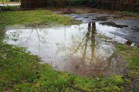
Tonight Showers and thunderstorms before 2am, then a chance of showers. Some storms could be severe, with damaging winds. Low around 34. Breezy, with a south wind 9 to 14 mph becoming west 20 to 25 mph in the evening. Winds could gust as high as 38 mph. Chance of precipitation is 80%. New precipitation amounts of less than a tenth of an inch, except higher amounts possible in thunderstorms.
-
We have to take these models and storms one at a time. It’s looking more and more like Sunday may be a surprise with a couple inches of wet snow. just my opinion.
-
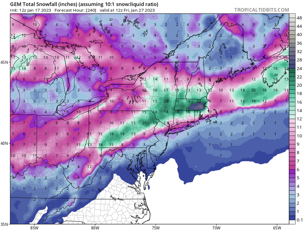
January in Pittsburgh
-
TWC is a joke and I don't watch them anymore. Only concerned about ratings. National fearmongering. Local forecasts are very general. As far as this week goes...we have 2 storms to track. Sunday night and Tuesday night. I'll be happy with a couple of inches on each one but maybe one of them can turn into something more.
-
Oh Canada!
-
Models are hinting at some pretty strong cold coming down on the weekend of the 27th. I think that will be our next time to maybe score something.
-
2 weeks away but we can only hope.
-
Come on Canadian!
-
Models show the cold coming back next week. Hopefully it will bring in some storm potentials to break this boring stretch.
-
You’re right. Just one big storm.
-
Thunderstorms tomorrow morning?
-
Yes, the cold air will be coming back so storms could be coming into play.
-
I am sitting at 0. The airport checking in at -4
-
I still think we are looking at a solid 1-3 and like Trout said it will be blown around so much that there will be grassy areas uncovered but some drifting in spots. At least the ground will be white for Christmas eve with temps in the single digits. As far as the snow goes it will be a minor event the will all come down early Friday morning and then light snow showers blowing around the rest of the day. What I am looking forward to is the extreme change and temps when the front comes thru. I am old enough to remember a front in the mid to late 70's when I was in high school where we had white out conditions for an hour or so and the temp dropped from the 40's to single digits in several hours. I remember it was hard to look out our kitchen windows because the wet spots froze up with the quick temp change. I say make sure you are up Friday morning and watch the front come thru. Who knows, you might even hear a clap of thunder.
-
Back to the good ole “wright weather” days.
-
I was traveling today so this is the first I’ve logged on. You can pretty much bet we won’t see 20 inches of snow. Fun tracking though. I’ll take 3-5 now for Christmas. Bring it.
-
I know it is early for snowfall maps but what the heck. It is Christmas Time! Also remember we have a Steelers game on Christmas Eve.
-
AT least the cold the cold should be here for Christmas and maybe a little snow on the ground which would be nice. Also maybe a clipper or 2 after Christmas if the Northwest flow continues. Maybe a couple 2-4 inch snows between holidays. Nothing set in stone but I'd rather have that then missing out on rain and ice.
-
It's still early but Christmas week looks to be quite stormy
-
Models definitely improved today. Looking better for cold and maybe some snow the week before Christmas. Fingers crossed
-
GFS Dec 13-19 the cold air is here. That will be the time for something if it holds.


