
anthonyweather
-
Posts
1,756 -
Joined
-
Last visited
Content Type
Profiles
Blogs
Forums
American Weather
Media Demo
Store
Gallery
Everything posted by anthonyweather
-
Went from ice storm to torch in 12 hours LOL
-
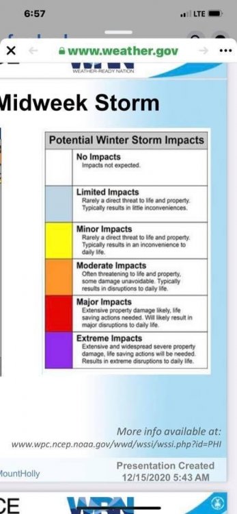
Trouble in the northern areas 12z nam
-
That’s what im saying, I should have clarified. I have 16”+ snowpack, I think those areas you highlighted should prepare for the worst, and hopefully expect rain. But I just don’t see it
-
So are GEFS
-
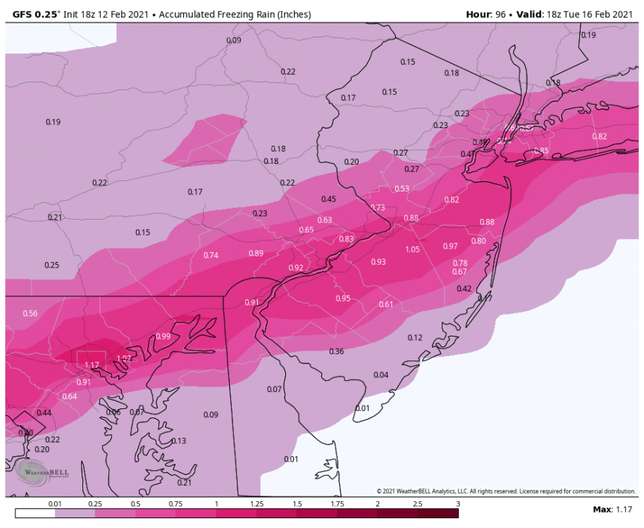
Big mess shaping up N&W of 95. Change my mind
-
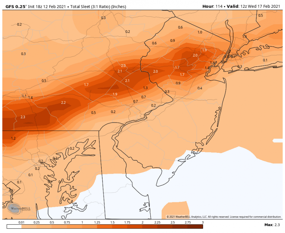
This screams major ice for n&w. Not gonna scour this cold out. Sorry
-
GFS
-

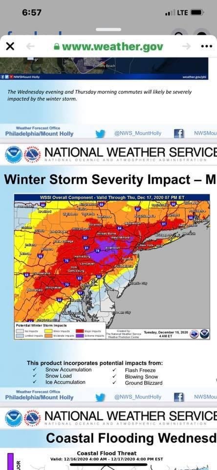
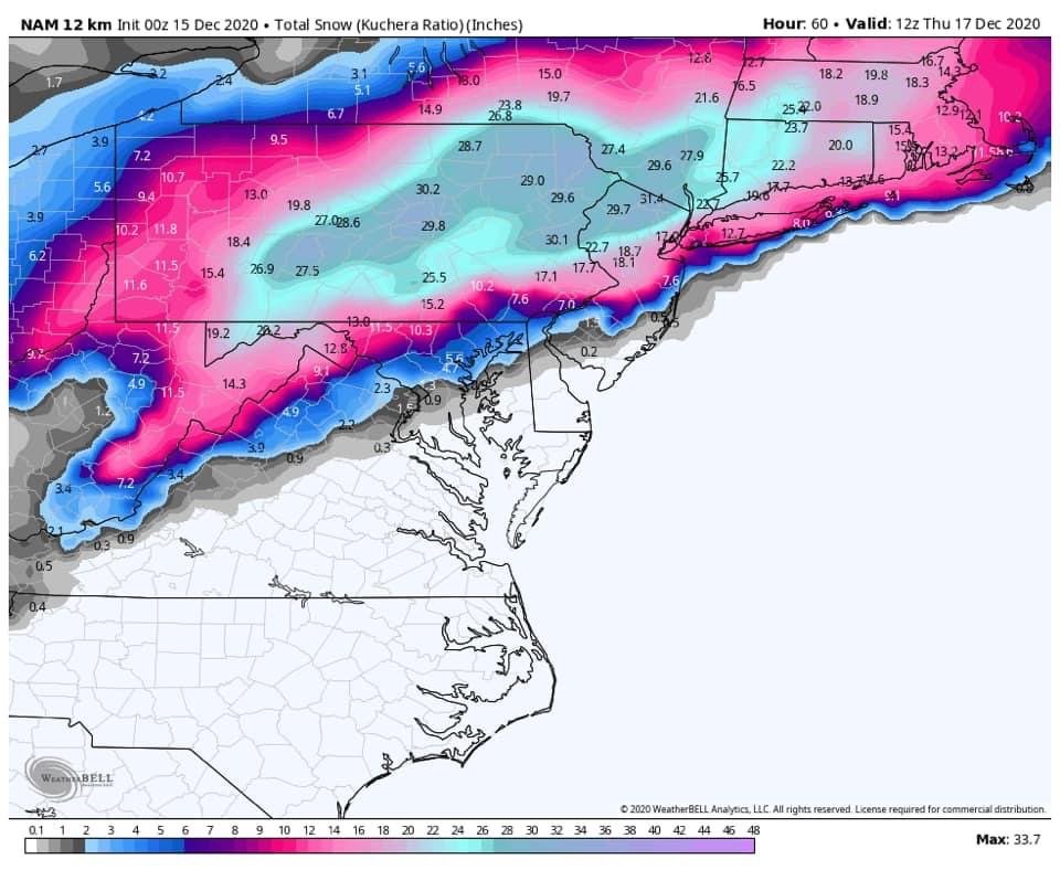
December 16-17, 2020 Winter Storm
anthonyweather replied to Ralph Wiggum's topic in Philadelphia Region
Mesos amping up the snow for at least the upper half of Lehigh county and points north -
December 16-17, 2020 Winter Storm
anthonyweather replied to Ralph Wiggum's topic in Philadelphia Region
Looks south of the valley. Accums in the low 20” range accordin to 3k -
December 16-17, 2020 Winter Storm
anthonyweather replied to Ralph Wiggum's topic in Philadelphia Region

-
December 16-17, 2020 Winter Storm
anthonyweather replied to Ralph Wiggum's topic in Philadelphia Region
What’s up fellas. Another year another NAM’D.
-
WINTER ARRIVES THIS WEEKEND EVENT JAN 18-19, 2020
anthonyweather replied to Albedoman's topic in Philadelphia Region
Full NAM CAVE to gfs... lol -
WINTER ARRIVES THIS WEEKEND EVENT JAN 18-19, 2020
anthonyweather replied to Albedoman's topic in Philadelphia Region
Eh, they say it’s good, never really thought so, typically in line with euro, we are both in good spots for 3-6 I’d guess, anything south of us not so much -
WINTER ARRIVES THIS WEEKEND EVENT JAN 18-19, 2020
anthonyweather replied to Albedoman's topic in Philadelphia Region
12z UK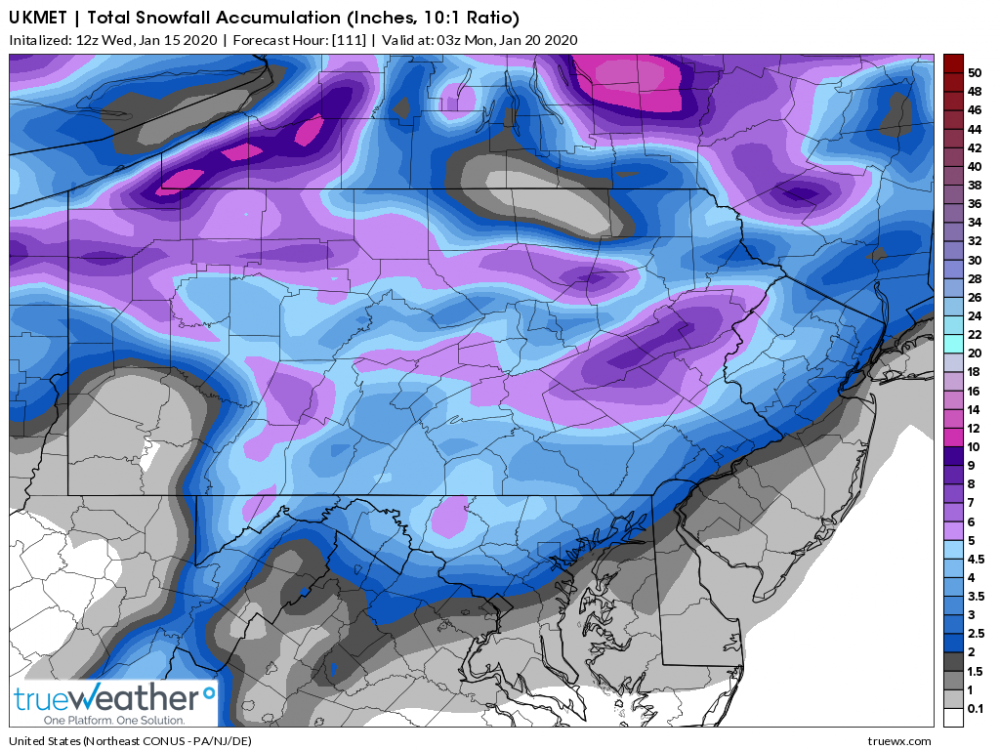
-
WINTER ARRIVES THIS WEEKEND EVENT JAN 18-19, 2020
anthonyweather replied to Albedoman's topic in Philadelphia Region
See we have now introduced sleet. What’s a “winter storm” without that? -
WINTER ARRIVES THIS WEEKEND EVENT JAN 18-19, 2020
anthonyweather replied to Albedoman's topic in Philadelphia Region
Euron adds 1-2” for most -
WINTER ARRIVES THIS WEEKEND EVENT JAN 18-19, 2020
anthonyweather replied to Albedoman's topic in Philadelphia Region
Starting to see a consistent trend in later start time, lowering accumulations around 95. Euro doesn’t start till 2PM now, following GFS and Canadian. Top accumulations around 8” with ratios (LV & Poconos) -
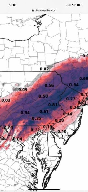
Snow, sleet, ice, and rain Dec 16-17, 2019
anthonyweather replied to Ralph Wiggum's topic in Philadelphia Region
The initial “thump” looks good, but what happens on the surface maps following is downright strange looking -
Rain to Snow Event Dec 10-11, 2019
anthonyweather replied to Ralph Wiggum's topic in Philadelphia Region
Bingo. Ugh. 2 hard to forecast storms with sky high bust potentials to start the year -
Can tell how quiet this place got, where this threat went... lol
-
My call - 2-3" of snow , freezing rain for a few hours for a crunchy layer, monsoon in the mid 30s by 3am (Lehigh valley ) Sent from my LG-H900 using Tapatalk
-
Yup... I tell ya what , Guarino nailed the blizzard, but what happened to him after he got fired?? He has like 6 Facebook accounts with different spellings of his last name. ShadySent from my LG-H900 using Tapatalk
-
And he did very well with the blizzard.... NotSent from my LG-H900 using Tapatalk
-
Unreal. 5 days out and you are all calling victories. Smh Sent from my iPhone using Tapatalk
-
Lehigh Weather Authority Sent from my iPad using Tapatalk