CoastalWx
-
Posts
167,017 -
Joined
-
Last visited
Content Type
Profiles
Blogs
Forums
American Weather
Media Demo
Store
Gallery
Everything posted by CoastalWx
-
-
I have no shame.
-
I like how models are trying to engineer a low developing on the frontal boundary from the low cutting NW of us later next week. That will whiff and cancel any coastal hopes.
-
Dude. You don't stop do you.
-
He's a few IPAs away from the truth.
-
He definitely may not be coming clean on a few things for sure.
-
That has been the season of winter lately. Used to be my favorite, but becoming less and less enjoyable. Too long of a season for this bullshit.
-
Dendrite complaining about shoveling a path to the chicken coops tomorrow while I'm posting in my speedo.
-
Let’s get 35 and drizzle there with a warm front stalled at MHT. We pray.
-
You know what will happen. Will be ice and snow from PF to dryslot. 38 and rain here while a cop in NYC fights off the mentally ill in Times Square where it’s sunny and 75. That will be this winter’s final rusty trombone for us.
-
I get it. I mean if there’s a big dog imminent I’ll be right there bunning away. But man got to be impressed with that signal. Only issue will be the anal leakage I mentioned from the north. That is possible.
-
Hopefully it’s a nice day like last year. Would like to go again. One of the best days of the year in the city when it’s nice out.
-
Unfortunately the GEFS have an anal leakage risk from the north, but overall a warm look. Certainly nothing even close to entertaining more faux threats.
-
Is that you with the hook ripping my intestines out?
-
I feel like painting my face war colors and yelling freedom. Call me William Wallace.
-
Once we watch another event that doesn’t come together, it’s on.
-
It’s coming and starts before that. You of all people have the best shot.
-
Man this is exciting. Just feels like a weight lifted off my chest now that’s it’s just about over. Freedom.

-
Wow
-
Doing it and doing it well. I represent Weymouth she was raised out in Northfield.
-
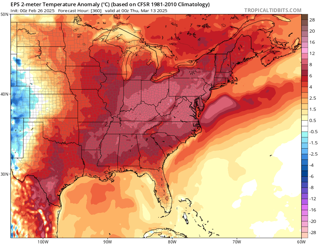
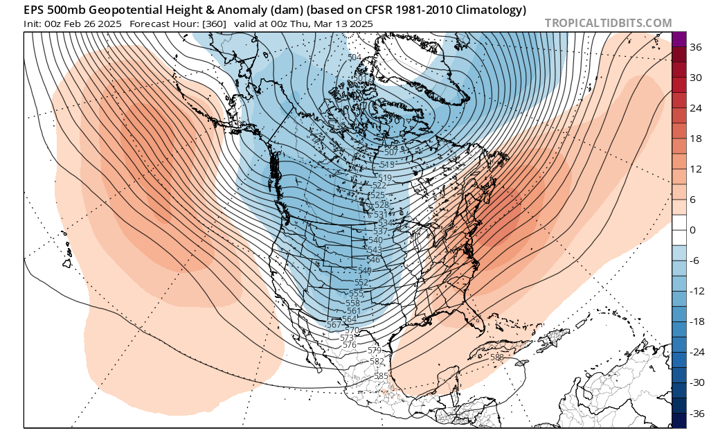
That is an absolute heat pump. I’m sure it will stop at NYC, but we can dream.
-
Euro is too. So glad we’re about done.
-
We’re actually still talking about snow? How about those 570 thicknesses approaching on the 00z gfs!
-
We 3/9
-
Nice day today. Didn’t even have to use my AK.