RitualOfTheTrout
-
Posts
3,468 -
Joined
-
Last visited
Content Type
Profiles
Blogs
Forums
American Weather
Media Demo
Store
Gallery
Everything posted by RitualOfTheTrout
-

Pittsburgh, PA Fall 2024 Thread
RitualOfTheTrout replied to TheClimateChanger's topic in Upstate New York/Pennsylvania
Yeah, and no antecedent cold either. Looks like it's one of those deals if its weak enough to track far enough under us there aren't enough dynamics to pull any cold in, and if it's stronger is tracks to close and the marginal cold that is available isn't enough. That arctic air looks like it's going to be real, no model rug pulls, so Friday - Monday at least should be cold with snow in the air. With an early season cold snap and warm lakes, if we can get a shortwave embedded in the NW flow might be a good way to score a minor event in that setup. -
Pittsburgh, PA Fall 2024 Thread
RitualOfTheTrout replied to TheClimateChanger's topic in Upstate New York/Pennsylvania
Maybe its the Mad Elf combined with watching it snow on TV talking, but I don't hate the post Thanksgiving period. Not a big storm look but gotta think more snow chances if that look holds. -
Pittsburgh, PA Fall 2024 Thread
RitualOfTheTrout replied to TheClimateChanger's topic in Upstate New York/Pennsylvania
Check out the steeler game, even if you don't care about football watch that band coming off Erie! -
Pittsburgh, PA Fall 2024 Thread
RitualOfTheTrout replied to TheClimateChanger's topic in Upstate New York/Pennsylvania
Looks like a batch of what should be snow about to move through per radar. Temp at 32, maybe a dusting incoming. -
Pittsburgh, PA Fall 2024 Thread
RitualOfTheTrout replied to TheClimateChanger's topic in Upstate New York/Pennsylvania
Day After Tomorrow type stuff here lol. Wind was insane, luckily not much damage other than a missing garbage can and my fire pit got moved about 8 inches... That's a first. -
Pittsburgh, PA Fall 2024 Thread
RitualOfTheTrout replied to TheClimateChanger's topic in Upstate New York/Pennsylvania
I guess this is a Mr. Obvious comment, but these maps are pretty garbage in these marginal temperature setups. I think it's likely the lowlands see an inch or less unless something really times right overnight. Going to be tough to stay cold enough during the day. Still nice to have some pre-season action lol -
Pittsburgh, PA Fall 2024 Thread
RitualOfTheTrout replied to TheClimateChanger's topic in Upstate New York/Pennsylvania
Could be a decent LES pattern setting up, not as exciting for us lowlanders (lol) but typical upslope areas like yourself might be looking good in another week or so. -
Pittsburgh, PA Fall 2024 Thread
RitualOfTheTrout replied to TheClimateChanger's topic in Upstate New York/Pennsylvania
Happened to tune into WTAE yesterday and saw their winter forecast, going to 32 inches. Similar theme, above average temperatures, below normal snowfall, but should be enough "cold" shots to eek out a snowier winter than last year. That's not saying much though, it will be tough to beat 16 inches for the season. Reading some others thoughts there is at least a potential this winter isn't a total fail if some things break right despite the overall above average theme for temperatures. It does look like maybe first shot at accumulating snow (thinking your typical coating to an inch overnight type stuff) Thanksgiving week with -NAO and a trough in the east if this look holds.
-
Pittsburgh, PA Fall 2024 Thread
RitualOfTheTrout replied to TheClimateChanger's topic in Upstate New York/Pennsylvania
Pretty awesome lighting show last night. Perfect to sit on the front porch and watch nature's firework display. Lots of cloud to cloud lightning observed. -
Pittsburgh, PA Fall 2024 Thread
RitualOfTheTrout replied to TheClimateChanger's topic in Upstate New York/Pennsylvania
Looks like another dry stretch coming up, barring any tropical impacts possibly 7 days. Hopefully it doesn't have any impact on fall foliage in the area, but maybe earlier and less colorful if the trend persists. -
Pittsburgh, Pa Summer 2024 Thread.
RitualOfTheTrout replied to meatwad's topic in Upstate New York/Pennsylvania
I'll take a warm-ish dry fall any year. Really no use for below average temperatures until mid November. I know statistically getting a below average month recently is not an easy task and that's more the point you are making here. From an enjoyment of the season perspective though nothing wrong with mid 70s, low humidity and nights in the 40s imho. My mind is starting to wonder into the "what will winter be like" thoughts now that we hit September. Looks like La-Nina will be in place. Given all the hype about last winter and all the great "looks", without much scientific backing I'd still give it equal chances of being snowier this winter than last (which isn't a high bar lol). -
Pittsburgh, Pa Summer 2024 Thread.
RitualOfTheTrout replied to meatwad's topic in Upstate New York/Pennsylvania
Definitely winter storm type cutoff. Would have been awful if it was snow lol. Hopefully its evening things out in terms of relieving the drought conditions area wide, I got a good bit of rain Tuesday so not mad this is a miss. -
Pittsburgh, Pa Summer 2024 Thread.
RitualOfTheTrout replied to meatwad's topic in Upstate New York/Pennsylvania
Got some gusty winds and pea to marble sized hail earlier today. Not a lot of thunder or lightning. Wonder if round two holds together or weakens once it crosses the areas from earlier today. -
Pittsburgh, Pa Summer 2024 Thread.
RitualOfTheTrout replied to meatwad's topic in Upstate New York/Pennsylvania
I dont disagree this hasn't quite been "historic heat" per se, but given we are getting it in mid June vs July and August which is more typical plus the duration still makes this a rather unusual setup. If this setup reoccurs later in July or August Id bet we get upper 90s. Of course cloud cover / storm development also threw a wrench in the forecast. Just like in winter, you dont always maximize a great pattern for a big storm I guess. -
Pittsburgh, Pa Summer 2024 Thread.
RitualOfTheTrout replied to meatwad's topic in Upstate New York/Pennsylvania
No doubt non standardized & less accurate equipment combined with varying procedures and changes in sensor location make over analyzing past data older than 30 years for comparison to today's readings a fool's errand. It would be interesting if some of those older technologies were run synchronously with the new technology to see the differences and provide solid data that would be hard to refute. In any case, the trend over the last 30 years is higher temperatures, no way to sugar coat that. For our sakes, let's hope the current period is perhaps a combination of constructively interfering factors all adding to more pronounced warming in the overall trend and not the beginning of the last chance to avoid any tipping points. Anyone caught in those storms out there today? Plenty of fuel, NWS makes mention of strong winds as the biggest hazard, curious how that is materializing in the strongest cells. -
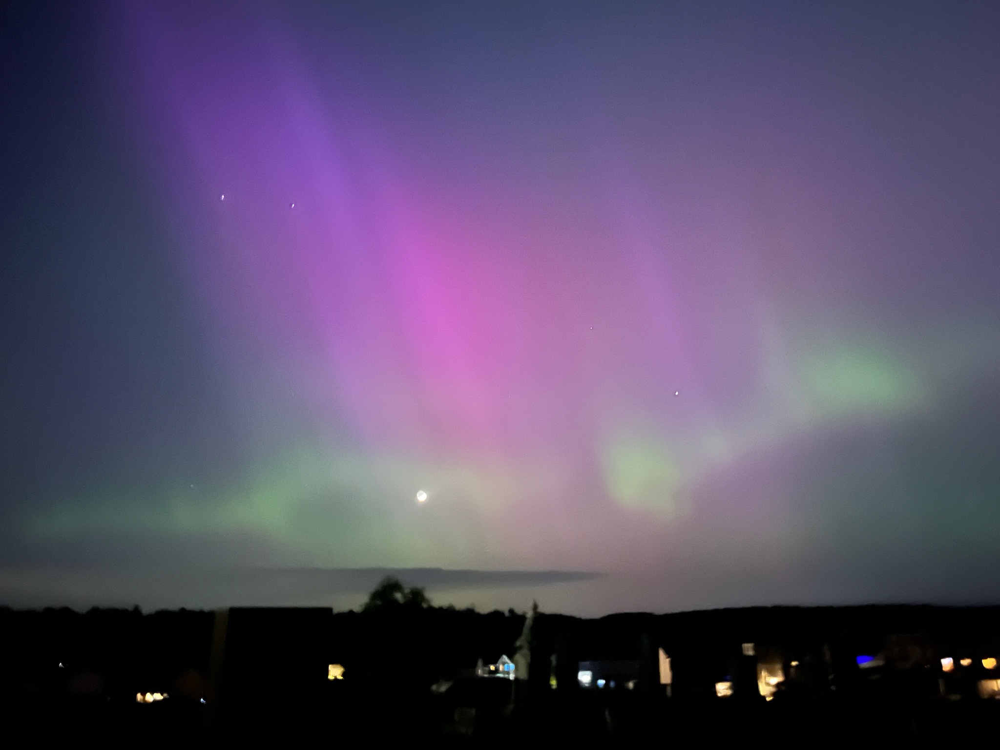
Pittsburgh/Western PA Spring 2024
RitualOfTheTrout replied to Ahoff's topic in Upstate New York/Pennsylvania
Pretty awesome for sure, we saw a pretty bright pulse, could see the waves in the colors. This is the best picture we got:
-
Pittsburgh/Western PA Spring 2024
RitualOfTheTrout replied to Ahoff's topic in Upstate New York/Pennsylvania
I've been feeling this one, usually this time of year you can cool down in the evening / overnight. Couple of borderline uncomfortable nights the last week or two, still holding off turning the AC on. On a side note, started putting in some of the garden, started a bunch of stuff from seed in March, but they've been outside and growing crazy and quickly exceeding the pots, likely due to this warmth. Assume now we will get several hard freezes in mid May. -
Pittsburgh/Western PA Spring 2024
RitualOfTheTrout replied to Ahoff's topic in Upstate New York/Pennsylvania
Spoke too soon, couple rumbles on the backend, nothing crazy though. -
Pittsburgh/Western PA Spring 2024
RitualOfTheTrout replied to Ahoff's topic in Upstate New York/Pennsylvania
Same, pretty gusty but not even a rumble of thunder. Looks like the line is rapidly weakening. Also seems to have split right before it hit my area which is a fairly common occurrence. -
Pittsburgh/Western PA Spring 2024
RitualOfTheTrout replied to Ahoff's topic in Upstate New York/Pennsylvania
Looks like a good call. Mother natures firework show lighting up the sky right now. -
Pittsburgh/Western PA Spring 2024
RitualOfTheTrout replied to Ahoff's topic in Upstate New York/Pennsylvania
Feeling the temperature drop in totality is something that goes understated as part of the overall experience, I knew it happened but until you feel it while the eclipse is happening can't really put words to it. Hard to imagine the temp didn't drop, unless there was influence from heat island effect or something. -
April 8th Eclipse- Last Easy One To See In My Lifetime
RitualOfTheTrout replied to Interstate's topic in Mid Atlantic
I hear you on this, I was looking at the maps (https://eclipsewise.com/eclipse.html) and really gets you thinking in timescales that illustrate just how brief a trip we get here even if all goes well and makes you appreciate getting to see this one. 2090s looking good for grandchildren though from an eclipse viewing travel perspective.. -
Pittsburgh/Western PA Spring 2024
RitualOfTheTrout replied to Ahoff's topic in Upstate New York/Pennsylvania
If I think about maybe not so odd PIT failed to drop temperature as expected. #Winter. -
Pittsburgh/Western PA Spring 2024
RitualOfTheTrout replied to Ahoff's topic in Upstate New York/Pennsylvania
Headed up to Northern OH, SE of Cleveland based on the satellite trends at the time. Clouds were only whispy cirus type so near perfect for eclipse viewing. It was pretty awesome, saw some stars, felt the temp drop, just jaw dropping watching it. Looked like there was some sort of flare or CME we could see. Son is 5, hes been drawing pictures of it all night, safe to say this will be a strong memory. Kinda like a snow storm, now I want another one. -
Pittsburgh/Western PA Spring 2024
RitualOfTheTrout replied to Ahoff's topic in Upstate New York/Pennsylvania
Well, she's going to have a great view above the clouds, but Im sure she will be with you to experience it. I've never experienced a full eclipse, but they say its awe inspiring / spiritual thing to see. Its going to be close, but some clearing coming into eastern OH now. Trends seem to be leaning towards that moving faster, so maybe with a bit of luck we can get a favorable window to see it. Never tracked clouds before, lol but got the GOES IR loop in refresh.