RitualOfTheTrout
-
Posts
3,468 -
Joined
-
Last visited
Content Type
Profiles
Blogs
Forums
American Weather
Media Demo
Store
Gallery
Everything posted by RitualOfTheTrout
-
 That looks like the next window for something more significant. We are going to need those waves leading up to it to push the gradient SE, so probably less confidence than normal on track / development of that system until those things get resolved.
 -
I don’t buy it yet. Seeing all those perturbations lead to a decent snowfall does raise confidence but I’ll need to see similar outcomes on other models and more importantly see it under 100 hours. I won’t be shocked if the whole thing is gone at 00z.
-
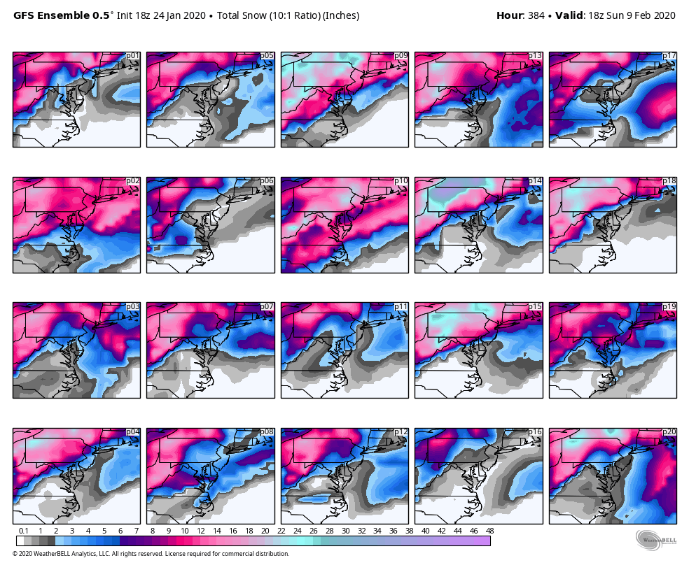
Heh, here are the GEFs through 384, P14 says we are above average for the season by Feb 9th lol If only!

-
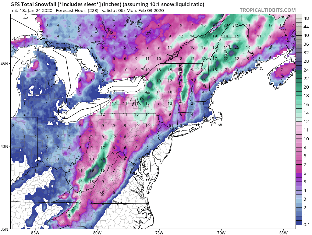
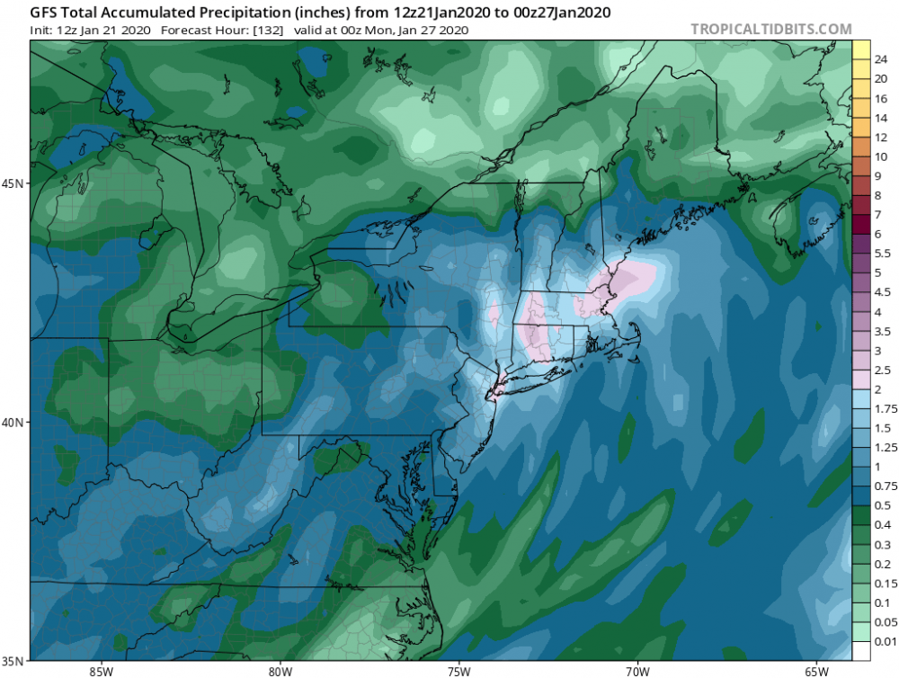
Yeah, this would go a long way to starting a fourth quarter comeback, 18z GFS: To bad it’s 7 days out.. we know it can only go down hill from here.

-
It does look active which gives us more roles of the dice to get a storm with a favorable track and cold enough air around. To this point it's been one of the lousiest winters in recent memory , and while we probably can't salvage the season as a whole a good Feb is still possible and statistically the ever so rare big storm is just as likely to happen in Feb 2020 as any other year. No reason to throw in the towel yet.
-
I agree, it's highly unlikely the models have this nailed down. That doesn't mean the changes that happen from now until verification benefit us though. It could be off by 400 miles but if its 400 miles further north the sensible weather is still rain for us. The pattern as a whole is just devoid of cold air, its all locked up over the pole with the uber +AO +NAO +EPO. The long range looks bleak now for snow chances as of today, I think the GFS has like 1 inch of snow through 384 hours for our area, that's about as bad as it can get for mid Jan - early Feb. At some point you'd think the rubber band has to snap with some of these indices, if it does hopefully it's in early Feb but the longer this drags on the more I start thinking it could be March and we go from 34-38 degree rain storms to 38-44 degree rain storms for March and April. Typically flips in the AO/NAO region just show up on models out of nowhere so if its going to happen at some point it may just show up and start moving closer in time. I admit to having little skill in the long range stuff though so reader beware lol
-
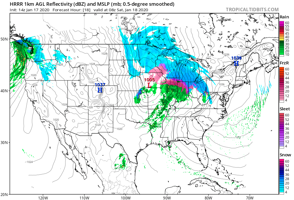
It's not really 3 days of snow. GFS continue to drive the Primary to far North and delay the transition. This does 2 things, what precip we do get is primarily rain due to the typical issues we have with a primary low that goes north and west of us that is further complicated by the marginal antecedent air mass so you get the resulting snowfall forecast: Second issue is due to the primary going so far NW of us we get caught in the dryslot between the transfer, so total precipitation over our area really isn't that impressive (about .25 - .35 ) until you get into the ridges and central PA.

-
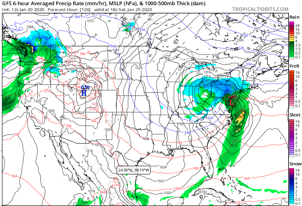
I agree, 18z GFS shows what happens if it holds on a bit to long. We get just enough warm air to rain and the secondary doesn't get going in time. Heh, just for fun loop through the OP 18z GFS, epic run for New York state, we get a nice hit too to start off Feb. Maybe we get lucky and the less than great pattern forces storms to take a decent track instead of favoring the east coast.
-
It's a very marginal setup with high bust potential. Reminds me more of a early March storm than mid January where being off by a degree or 2 makes the difference between 1 inch or 6 inches. My thought is we need the that energy in Eastern Ohio to die out quicker and merge with the main low pressure sooner. That would help with temperatures and may help the main low wrap up a little faster. Both of those things would help us get the most of this. Who knows how close the GFS to being correct though.
-
I just cycled through 00z / 06z runs and there is definitely support for something similar to this showing up on GFS / GEM / Euro with some support from ENS too. Verbatim nothing looks like a clean hit for us but small improvements over previous runs. Guess I'll be tuning back in at 12z to see if the look continues to show up.
-
Yeah, it's a perfect winter day out there. Nothing beats snow falling with temps in the 20s. To top that I've gotten more snow on the ground today than from yesterday's "storm". Just enough to take the kids and out and pull them around on the sled and rough house with the dog.
-
Flipped to all liquid here.. Somewhere between ZR and plain rain now. With the upside of this only being 2 inches it is a bit disappointing but it’s not like we busted on a 6-8 inch forecast to this outcome. Barring an arctic antecedent airmass and a high to the north locked in by a block storms cutting through Chicago will rarely have a better result. Our best chance with a west track to bust high is with a miller B that jumps faster than modeled in my experience.
-
Snow has resumed here, not expecting it to last very long though. Dog just came in and was coated in nice flakes cause of course he had to wait til the dryslot filled in to go outside lol
-
About a quarter inch from the first wave. The main area of precip is on our doorstep now with some pretty decent returns on radar. My gut tells me it’s probably sleet but will find out shortly.
-
Man... I never thought back in mid November when I scored almost 4 inches off those squalls that “event” would be the leader headed into Feb... Heres to an over performer despite the lack of much upside.
-
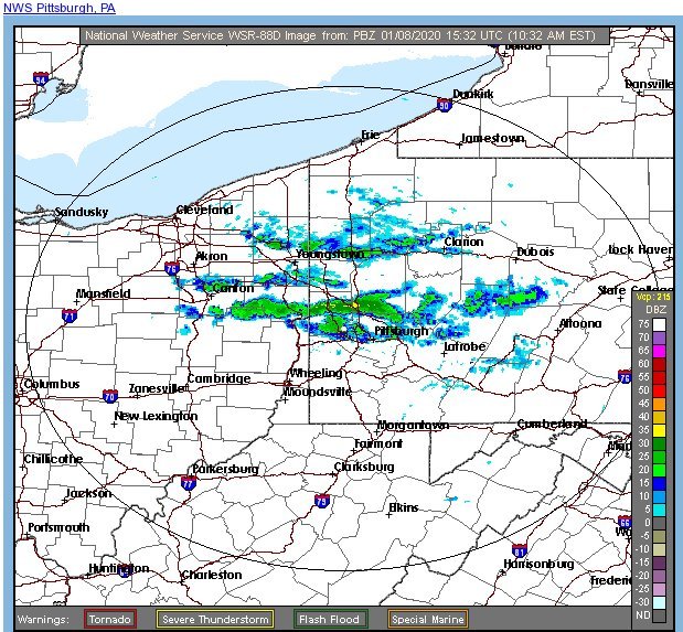
I only ended up with a coating. Driving around last night I ran into a couple decent bands in a few areas that probably had an inch or so on the ground but I'd say 1.5 -2 is probably a jackpot amount. Gotta love the randomness of LES bands. NWS has North of I-70 in the 2-3 inch range. Now that we are getting closer to the start, most of the shorter range models are keying on there being an initial slug of moderate snow to start this event followed by a bit of a lull before the main area of precip arrives. HRRR at the end of its run just for a visual of what I am talking about. How potent that first batch is combined with whether or not we can start off the second round as snow or we warm to much and its sleet/rain/mix right off the bat is the question. This storm is a good bit further West than our typical slop storms that drive up right over top or just to our West through Ohio so that probably lessens initial warm tongue to some degree. My thinking now is most of us top out around 2 inches that gets compacted with mix, and if we are lucky there will be something left on the ground for the next couple cold days that freezes into a glacier.


-
NWS agrees on the possibility of some decent snow shower potential: SHORT TERM /6 PM THIS EVENING THROUGH SATURDAY NIGHT/... Snow showers will continue into the evening with lake enhancement becoming more of a factor as air/lake delta-T values increase and DGZ lowers further into the boundary layer with continued cold advection. The 06Z NMM and HRRR hint at a band setting up with a Huron/Erie connection early in the evening...so there is potential for localized snow accumulation higher than in the current forecast. Future hi-res runs will need to be monitored to see if models show continuity.
-
Welcome! Always great to get more folks from our area involved. Always nice when we are getting a storm for more observations etc. I think most of us in the Pittsburgh thread are basically knowledgeable hobbyists so don't feel like you can't share your ideas. When things look interesting for us typically some of the Mets from the Central PA thread will stop by with some solid analysis too.
-
No matter the outcome of next weekend it appears some legitimate winter weather may be on tap. Odds probably favor the slop storm outcome next weekend that we have all come to know and love but it beats 70s right? Plenty of time though for things to change, if it was a modeled SW PA blizzard we all know it would change, question is does it change enough to affect sensible weather.
-
Some snow squalls making their way into Northern Allegheny / Westmoreland now, I wonder if they will be able to hold together. Would be nice to see some snow coming down.
-
Yeah, after a few brief shots at more normal winter conditions the next couple days and again next week it looks like models are locking into a pretty robust SE ridge. Could be towards the end of January until things hopefully improve. Maybe we can manage to get something before that sets in and even if not in Jan you can fluke your way into a storm so while not optimistic right now still worth monitoring. I'd love to get a cold and snowy January one of these years rather than these miserable Springs of late but that probably won't be the case again this year.
-
Near 570dm ridge for Christmas day.. All I can say is: Could push for top 5 warmest Christmas days with that. Still looks like some sort of pattern change near the new year is on tap.
-
Snow squalls / bands were fun today. Looks like one last round moving through now before we dry out and moderate, unfortunately just in time for the Holiday. While we can never roll out a fluke setup or transient cold shot long rang not looking great for snow prospects, hopefully by Christmas we can see the signs of a good pattern locking in for Jan.
-
I agree, you can pretty much forget tracking any threats past day 4 or 5 in this type of pattern. I am a bit less optimistic about the upcoming 7-10 day period than I was 5 days ago but with fast flow maybe something sneaks up on us. Overall nothing looks to lock in for the next 10-14 days, so expect cold then warm with maybe our best shot at snow a quick thump prior to the ever loathed slop.
-
That's not a bad look, I'd think that would keep us on the cold side of any storms, obviously subject to change but it will be interesting to see how things develop over the coming weeks.