RitualOfTheTrout
-
Posts
3,468 -
Joined
-
Last visited
Content Type
Profiles
Blogs
Forums
American Weather
Media Demo
Store
Gallery
Everything posted by RitualOfTheTrout
-
 Well I went to work Wednesday planning to only work a half day but some things came up and ended up working 18 hours and missing the whole storm practically outside of looking out the window every half hour or so. Driving home at midnight was fun lol It was a nice storm for us, driving back in today it was so picturesque like a Bob Ross painting.
 -
It's crazy when you think about it but true. Can we get another storm and make it a December to remember?
-
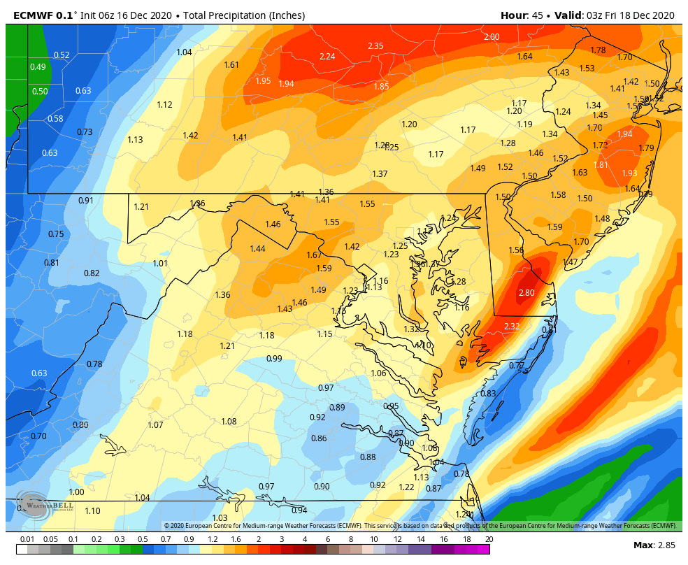
It is tough to gauge these maps with various snow algorithms when trying to ascertain what has changed one run to another etc. Here is 6z Euro total qpf. Looks like Allegheny ranges from about .6 - .8 from east to west across the county. Obviously snow growth / ratios will determine what that equates to on the ground but seems pretty reasonable imho the city should end up with around 6-7 inches. GFS is a tenth or so less .5-.7 across the county and the 3k NAM is probably right in the middle of the two. If this holds for 12z runs we are game on. The trend we saw in my opinion had a little bit to do with both the storm moving a bit SE and the models coming down to earth on qpf amounts due to getting a better handle on where the CCB sets up, which they all tend to be high at range. I personally never bought into any of those maps showing 10+, for something like that we really need the closed low feature. I think that was one of Joe Denardo's rules of thumb for big snows for our area, if you aren't on the northern periphery of a closed 700mb low be very careful forecasting big snows.

-
NWS upped totals in the warning from 5-8 to 6-9 I see.
-
I'm busy pouring blood over my snow idol statue, conducting a seance to conjur the snow gods and various other paranormal rituals of the ocult to give me temporary control over mother nature to keep any east trends at bay. Oh yeah.. I mean me too.. just eating some dinner.
-
Central PA - Winter 2020/2021
RitualOfTheTrout replied to MAG5035's topic in Upstate New York/Pennsylvania
Good, I'll have my lawyers ready the contract for signature. -
For now the 18z NAM is well within the envelope of tracks. If we see a similar issue in the rest of 18z data and a continuation in 00z then you could argue a trend back SE is underway but we are running out of time and the goal posts should be fairly narrow at this point.
-
Looks pretty similar to Euro. We are getting close enough now I fully expected the NAM to come back down to earth. Honestly 14 is still probably overdone.
-
Hopefully he lost the URL to the forum. I actually wondered if the prospects of a big storm would draw him out of hiding.
-
I was thinking the same thing, depending how this plays out we are probably only marginally behind the entire last season total by mid December.
-
Yeah I’m debating whether I should work half a day or just take the whole day off. I want to enjoy watching it and take the kids outside etc but not worry about having a 3 hour long commute home lol
-
You can also always check their Facebook Page https://www.facebook.com/NWSPittsburgh/ too. I find that even when the discussion's aren't updated they do seem be quicker to post their thinking via that medium. Also good to check during the storm, sometimes they will update with some localized info like where a band is setting up.
-
Will this do?

-
Looks like a good range for now given the possibility of briefly reduced ratios etc. Can always adjust the ranges a little bit again tonight one way or the other if needed without making big swings.
-
It varies based on where you are getting the data, two places I use most frequently are pivotal and tropical tidbits. On Tidbits when you are looking at the model data click on the "Upper Dynamics" / "Lower Dynamics" button to view panels other than surface / precipitation etc.
-
That's a pretty significant bump, one more like that would likely push the gradient out of Allegheny County. Looks like it's slowly caving towards the Euro.
-
Great looks overnight continue into this morning. I am skeptical of anything over a broad 6-8 given the caveats outlined by jwilson / NWS but given where we were even 36 hours ago things are looking good right now.
-
So sorry to hear about your loss, can't even pretend to understand how that would affect you on so many levels. Glad you are back and I hope you can enjoy tracking with us again. Looks like we may be on the verge of snatching victory from the jaws of defeat on this next one.
-
If by horrendous you mean lack of details in the discussions at times I don't disagree. They aren't always bad depending who writes them up. Fries and one other who's name escapes me usually do a pretty good job. I did a skywarn class several years ago and afterwards talking to the presenter I mentioned enjoying reading Fries detailed discussions and he said he had heard that from others too ( specifically local news Mets etc) I'm not sure if he is even still at our office or not these days.
-
They won't update map totals / expand watches etc until the full 00z suite is in and any required coordination with other offices if necessary is done.
-
Looks like they are factoring the relatively quick movement and marginal surface temperatures which give weight to the conservative approach.
-
So we have the Euro and NAM looking like a solid 4-8 across the area, GFS is probably 3-5 and Ukmet / CMC are like 1-2 I feel the NAM and Euro are probably a bit overdone at this juncture but if we ended with say a 70-30 split between the Euro/NAM camp vs GFS and toss CMC and Ukmet we end up with a solid Advisory event.
-
That's the best the Euro has looked for several runs now. Seems there is little NW shift with all the 6z models.
-
The general trend today has been to shift the totals east. Given the setup I had in my head 6 inches was probably the upper limit on this for us. If I had to put out a guess based on today's runs I'd say 2-4.