

RitualOfTheTrout
-
Posts
3,468 -
Joined
-
Last visited
Content Type
Profiles
Blogs
Forums
American Weather
Media Demo
Store
Gallery
Everything posted by RitualOfTheTrout
-
 It doesn't look great, but it's still got the primary farther north than anything else so we rain / mix. In my opinion our biggest failure option is an early transfer, want that thing to slide just to the South of us then spin as it transfers. Quicker transfer means the better totals cut off in central Ohio then pick up again in central PA as we basically get jumped over in the process.
 -
Sometimes NAM at range can give hints to what other guidance will do, and a little more push from the confluence isn't out of the realm yet so missing to the South still on the table. It's a narrow window to maximize snow with the primary tracking like that and not ending up with slop or a whiff or dry slot.
-
It was a good run, We have CMC, UKMET and EURO (and it seems like GFS is trending towards these guys) all showing at least 6-10 inches, hopefully no big changes in that track and we can start narrowing in on a tighter snowfall range in the next 24 hours or so. The coastal development not like last nights Euro, but that probably won't be nailed down just yet given all the complexities associated with it and its still a little past the 100 hour mark whereas the track of the primary is under 80 hours now. If this were deal or no deal I'd probably take it and run at this point.
-
Yes, it's going to be a good run, maybe not last night worthy, (remains to be seen) but so far tracks the primary in a very good spot for us and not stingy on WAA stuff.
-
UKMET looks good with it's track of the primary, looks like it keeps it south of us similar to Canadian, most of the mix stays south of M/D line. That's my main focus, the hail marry miracle inland coastal we saw on 00z Euro probably is not going to happen based on other 12z models so far today, but if the Euro throws that out there again maybe we start seeing if there are hints of that in future runs of the other models.
-
12z GFS doesn't look like it's going to make any friends in our section of the world, drives the primary into SWPA, so a lot of the front thump is sleet / zr / rain then the coastal doesn't throw much back to us.
-
Yeah that was perfect on 00z Euro for the WAA, then the capture and and riding inland helped get some of the coastal snow back our way. The 00z op did seem to be an outlier though among it's ensembles , and 6z isn't nearly as good. 6z GFS though finally stopped driving the primary to Cleveland. 12z runs today should be interesting to see if we start seeing more evidence last nights Euro gains support.
-
Euro has been fairly unrelenting on that idea, and it's been pretty steady with the snow hole idea but it has improved somewhat. If that was some sort of snow max bullseye no way it would stay from run to run. Until I see it get on board I'll be skeptical of anything over a couple inches, but the GFS and GGEM show how we could get a bit more.
-
GFS and CMC both give us a decent thump from the primary. CMC is a bit further south than GFS with it so I think that is a better outcome. I wouldn't mind seeing even a tick SE on the CMC in terms of that primary. If that's going to be the way this plays out it would be nice to see the Euro show us getting something, it seems to keep the primary much further west so we don't get as much of the front end stuff. As others have mentioned the big jackpot totals from the coastal redevelopment and possible subsequent stall as it phases are off the table. For us to get snow from a coastal it needs to be a mature circulation with a solid CCB and ideally run inland through Eastern PA. That's not to say we won't get some light snow etc but our main focus should be milking as much out of that primary from having it take a good track and die off in the right place.
-
I'm with you as it's currently modeled. Baring some other piece of energy or something showing up and altering the general look I agree with your previous post that the upside for us is 4-8 type event which I would take any day of the week.
-
It's still a good 5-6 days out so it's unlikely this exact progression plays out this way. One way to look at it is we really don't have anything to lose. All else being equal on the Euro get that primary to slide east 100 miles before the transfer and we probably manage a decent 3-6 inch event.
-
Primary is way to far West for us, we want the primary to come up in WV, then sit and spun as it transfers to the coast. As is we are stuck between the two and don't get much. GFS takes the low to far north, if we end up with a compromise between Euro and GFS in terms of latitude/longitude the primary makes it maybe we are in business for several inches. As it stands now on the Euro we are the big losers on this one.
-
I haven't paid much attention to this event either, but earlier in the day I did check the hrrr and it showed a brief burst of snow this evening and low and behold I just looked outside and it's snowing.
-
When I said low probability I was referring to how it managed to snow for 48 hours straight not necessarily any one outcome or that a storm of some sort was unlikely.
-
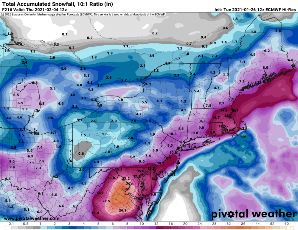
It has been an odd month in some ways, not a torch or shutout pattern but just couldn't seem to get anything to come together yet we have managed to nickel and dime our way to over half our average snowfall for January. Just a few days ago I thought this week would be pretty busy tracking today and Thursday but those evaporated pretty quickly. Looks like the next opportunity for something more organized comes Sunday - Monday next week. The CMC has a fun but low probability miller B type setup with almost 48 hours of snow falling (as illustrated in the map Rd9108 posted) but at this point all the models have a storm in the vicinity around that time so maybe we get the chance to roll the dice again.
-
Well guess I should have held off posting this because everything has gone the wrong way since... Literally every feature, the TPV is pushing south faster, the Monday storm is not moving out as quickly and the SW for the Thursday storm is trending faster. It would be asking for a lot of stuff to be modeled wrong at this point for us to have a chance at even a few inches, but we are still 5 days out so who knows. Worst part is next storm after will probably cut and give us rain lol
-
This setup bares some similarities to Feb 2010 with the features, big block with a wall of confluence that will shunt the storm East once it moves so far North. One difference now is lack of the big STJ firehose of moisture. I think there is room for this to come north if it ends up being more amped and the confluence is weaker. Overall though I agree our biggest issue is suppression and this setup doesn't have the same upside potential as that storm in terms of snow totals.
-
Wow no kidding, just saw GFS, that would be a blizzard for areas SE into Maryland / Virginia. There's a limit to how far north it can go with the block in place but we could get a solid event out of it as it stands now.
-
While I agree it'll probably end a quick death based on the past history under modeling speed and degree with which the warmth overwhelmes our area it does look like GFS and CMC keep pushing the system further West which would still give us a slug of WAA precip but less warming. I guess I'm just saying don't sleep on it, outcome may be more wintry in the sleet and freezing rain department than it looks now.
-
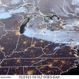
Some brief but moderate snow showers moving through right now. Gee, you think we might be getting some moisture influence all the way from lake Superior? Thought this satellite shot was kinda cool, you can clearly see the stream of clouds right off the lake.
-
Overnight runs looking better again. Went from warm rainers to maybe needing to pull out the detour sign. It was cold last night, expected a bitter morning not really paying attention to the forecast for temps but it had already warmed up near 30 by the time I left for work this morning.
-
The more intriguing looks have devolved with the primary making it further North before sliding East. Lots of warm tongue looks on last two run looking at EPS individual panels. Hopefully we see some improvements or we can kick to the next threat window.
-
Don’t want to overlook tonight, looks like 1-2 inches. Let’s see if this can keep with the seasonal trend and max out.
-
Good to see PA with several chances at some bigger events next week. That map comprises probably 3-4 discrete events over the 360 hour timeframe. To bad it’s not from one storm that’s only 24 hours out.
-
I agree all events have met or exceeded expectations and to top it off we had a storm Christmas Eve and a white Christmas to boot. As I type light snow continues to fall outside. We will probably add a total of 5-6 more inches over this 7 day period starting Saturday that clocked in at 3.2 inches.


