RitualOfTheTrout
-
Posts
3,468 -
Joined
-
Last visited
Content Type
Profiles
Blogs
Forums
American Weather
Media Demo
Store
Gallery
Everything posted by RitualOfTheTrout
-
 Looks like this one is wrapping up. One band to the north that should pivot South overnight but I think the bulk of our accumulating snow is about done for the city and north. Saturday keeps trending East with one low and the northern energy looks to barely hit us. Hopefully another 1-2 type deal at least but will have to see how it look once in the short range.
 -
LaNina typically favors cold out west / central US due to tropical forcing that favors SE Ridge. The models want to push it East but as we get closer the effects of the ridge are better resolved. By all rights a Nina Feb is usually warm, but we have the extreme blocking and piece of the PV squishing the ridge keeping us in the game.
-
Measured a hair over an inch of new snow. I've been on the northern fringe of the better returns but finally pushed a bit North, currently getting the best rates of the event so far.
-
Moderate burst here right now. Roads look like they are a mess already.
-
That's been the theme this winter though, more NS interaction, only to see less as we near in time.That said can't dismiss out of hand GFS depiction, but I'd hedge towards some sort of compromise between GFS / CMC solutions following the seasonal trend until proven otherwise. Agree with analyzing thermals at this juncture, if you do it's for pure entertainment purposes. The Euro depicting zr with temperatures in the low to mid 20s is not something we see around these parts very often so I thought it was interesting to point out.
-
The Monday night into Tuesday storm Euro is showing about .7 qpf, but it all falls with 2m temperature between 17-26 degrees. Verbatim it would be snow to sleet to freezing rain, and it would be legit freezing rain at those temperatures especially when you consider the ground will already be well below freezing with snow cover and its happening very early morning. I'm not a big ice storm fan, but if your going to do it.. do it right lol
-
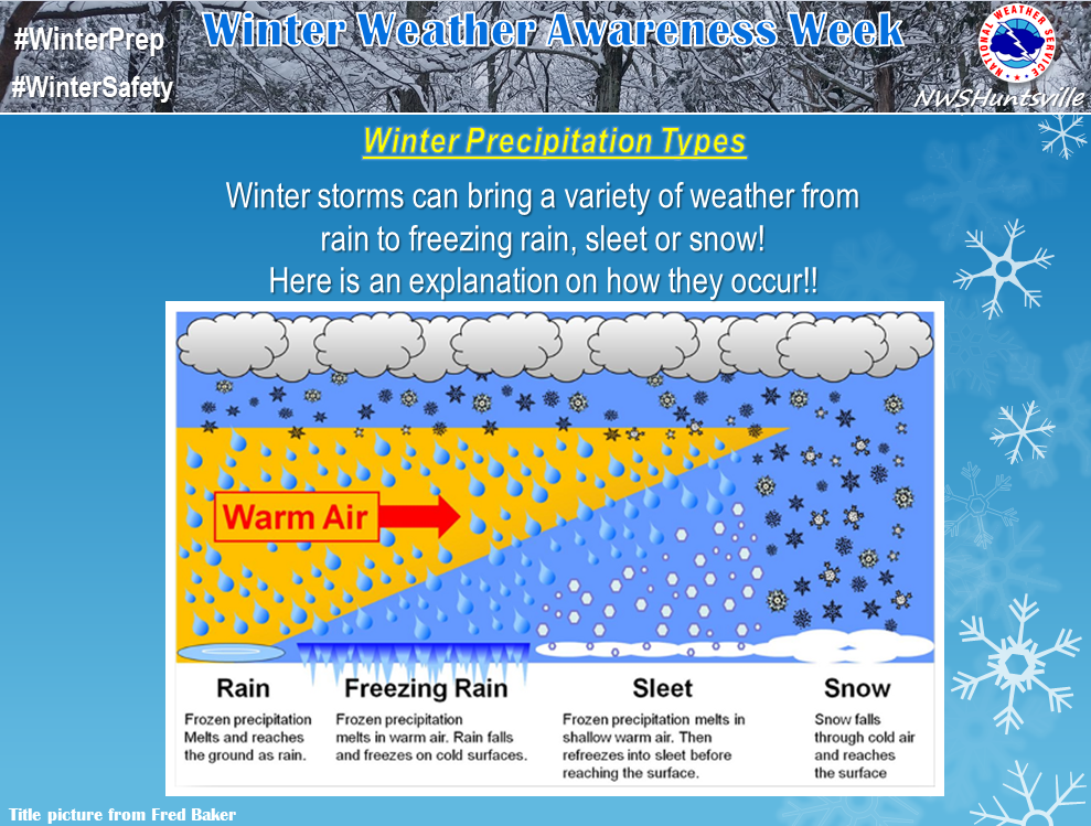
It will depend on which layers of the atmosphere go above freezing. Models won't have a good handle on this until short range. This graphic helps visualize it: So even if the 2M temperature is 17 you could still see sleet or freezing rain if there is a warm nose somewhere in the column. A lot goes into this though, say you have a high to the north funneling in low dew point air, during heavy precipitation maybe you can wet bulb the column to 0 and get all snow, then during lulls you get drizzle / sleet. There are a lot of variables that go into figuring out p-type and snow ratios. You can't just say it's 20 degrees so ratios will be 15:1 (Not saying this is what you were implying just pointing it out.)
-
I’m wondering if we see Sunday trend towards a lesser event and maybe bigger storm Tuesday.
-
Crazy how far apart those two are on those two storms, GFS seems to be holding strong with the idea of a cutter at 6z while Euro has a weak low out off the coast. Nearer term let's see if there are any North adjustment s for tomorrow. I wouldn't mind getting another 1-2 on top of this one.
-
I'm in the same boat, really nice to not have to wake up earlier to shovel / clean off the cars and fight with traffic and poor road conditions. Can just sit and look out the window while working for now and do cleanup this afternoon.
-
Measured a little over 4.75 here about a half hour ago. Won't be surprised to end at or slightly over 5 if we can manage another hour or two of the light stuff.
-
Nothing beats snow falling on frozen ground with temps in the low 20s.
-
I was thinking the same thing! Coming down moderate to heavy right now. Looking on the radar we are probably under the same band right now.
-
It's all about where the frontogenetic band sets up. As seems to be our luck this winter it might setup right over Allegheny county. .NEAR TERM /THROUGH TUESDAY/... Strong jet-supported will aid in spreading snow across the region tonight. A frontogenetic band is likely to set up over eastern OH to west central PA, generally along the I-70 corridor during the early morning hours of Tuesday. With surface temperature in the 20s, saturation to 300 mb, and coincident omega, aforementioned frontogenesis will likely result in heavy snow at times, and for those under the Advisory, 3-6 inches by the morning commute. Where the frontogenesis develops, and sits for several hours, is where the highest snow totals will be. There will likely be a fine gradient in snow totals.
-
I’m hoping we max out on this one, I’m thinking the next wave will be less of an impact possibly for us and more so SE. That’s usually how these things go, each successive weak wave targets further South as the boundary gets pushed South by its departing predecessor. I could be wrong, but if I had to guess that’s how I would hedge my bet.
-
This whole board is irrational if you think about it lol People rooting for severe thunderstorms, hurricanes, crippling blizzards, epic heatwaves etc. Thing is these weather events will happen whether someone is "rooting" for it or not. The raw power of nature and the struggle to understand it and make sense of a phenomenon that affects me everytime I walk out my front door is I think my motivation. We are all free to find joy in whatever aspect, you want a cold outbreak, some want weeks of snow cover, some want cold powder, some want heavy wet snow.. the list goes on and on. Take it day by day and make the best of what happens. Living and dying every 6 hours taking model output verbatim is a sure guarantee you will have stress and an anxiety from this hobby.
-
The first chance tonight looks like a solid 2-3 inches, but looks like a smaller stripe where 3-5 inches could be possible. 12z NAM has that right across Allegheny county. Hopefully some more clarity on that as we get in range of the meso models. The event later in the week Wed-Thurs might target areas SE of us but we are still in the game and hopefully worst case we grab a few inches on the northern fringe. Models probably won't nail it down until tonight's system is out of the way.
-
Assuming the blocking remains intact its going to be hard to see a 100 percent rain event. Not impossible of course but I'd hedge my bets even a wrapped up monster cutting west would deliver at a front end thump, and most likely be forced into a miller A/B type hybrid event.
-
Just quickly looping through the models this morning it looks very active. Going to be a dance I think keeping the TPV press to lock in "cold enough" but not push the storms SE of us. Given the shear number of chances I'd lean towards being satisfied even with slop / mix storms especially if it all freezes into a glacier and we keep building on it. Those qpf laden packs of ice / zr / snow really have some staying power, seems like it's been awhile since that has happened.
-
How much is spent specifically on runing / improving the GFS? Personally I think it would be a mistake to just kill the GFS and rely on foreign agencies / governments for our weather models. (Not saying this is what you think should happen). Don't forget the Euro is at least partially privately funded and is allowed to use data from satellites etc the GFS cannot (Russian / Chinese) No doubt it has an edge in the physics department as well as a higher resolution but the GFS still schools it on pattern recognition sometimes and usually in medium to longer range forecasts you see some sort of compromise. Anyways, looks like single digits Monday morning. NWS calling less than an inch for tomorrow.
-
GFS has a cold bias in the long range. So I'd take any cold it's showing let alone record negative double digits with several grains of salt until closer in time and corroboration from other guidance. That being said, way to far out to know what will happen end of next week in terms of any storm. Can't expect models to lock onto the correct outcome at this point. Looks like we have a shot at a couple lighter snows earlier this week, focus on those for now if you want to save yourself some stress and irritation.
-
18z NAM ticked NW again with more negatively tilted trough. I think we are out of the game for anything big, just seems to get going to late but should NW more amplified trends continue we might be able to steal a few inches from this. Crazy when you think just a couple days ago the was so far South.
-
Severe cold rarely leads to big snow, the pattern required for that is usually dry. Don't get me wrong, I don't mind an Arctic blast if we have a solid snow pack or a big overrunning event with snow in the low 20s. The models are waffling with features (mainly the orientation / position of the PV) which in turn have downstream effects such as either pumping or squashing SE Ridge. I'd rather have cold enough and keep the boundary just to the South of us and get a chance to roll the dice as storms ride along it. I still think it's possible we get a blast of Arctic air at some point this month, maybe coldest of the winter. Legit cold air is nearby now so it would only take a brief interlude of cold favorable indices to deliver a shot.
-
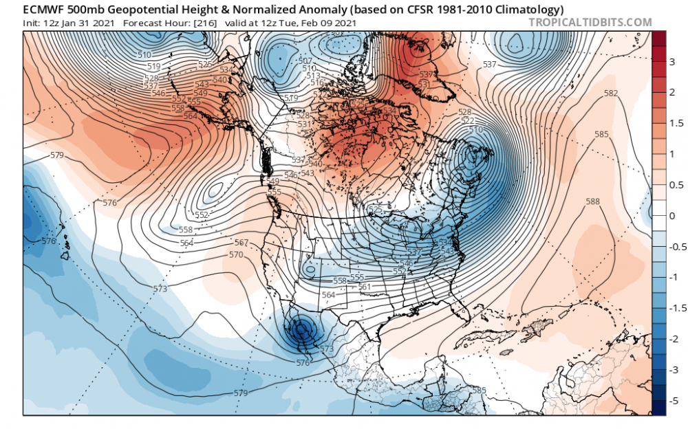
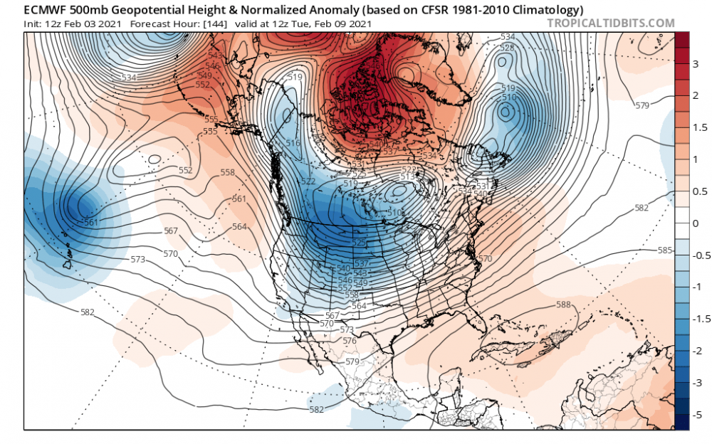
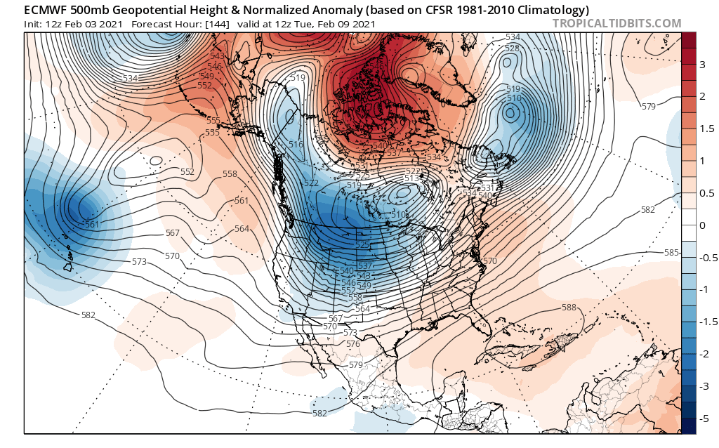
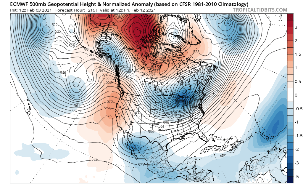
Models are pulling back on the Arctic blast, maybe a delayed but not denied type deal, but what was once looking pretty brutal has moderated due to the trend to pop a ridge in the East in response to splitting the PV rather than one elongated piece of the PV with majority of the energy in the East. Now look at today, PV is split with the stronger piece out west, pumping a ridge that connects all the way up the NAO block. Throw a storm into that 500 map and you can see anything that develops would likely go to the west of us and pump heights even more with SW flow ahead of it. Recipe for a warm up for sure. Going a few days out from here the piece of PV out west rotates eastward and I would think some cold will follow. That of course assuming that progression is correct.