RitualOfTheTrout
-
Posts
3,690 -
Joined
-
Last visited
Content Type
Profiles
Blogs
Forums
American Weather
Media Demo
Store
Gallery
Everything posted by RitualOfTheTrout
-

Western PA/Pittsburgh Winter 2021/22 Discussion
RitualOfTheTrout replied to meatwad's topic in Upstate New York/Pennsylvania
Probably an end to the snow cover stat too. It was technically better that last few storms with the GFS being to far SE at this range giving us more hope so there's that right? -
Western PA/Pittsburgh Winter 2021/22 Discussion
RitualOfTheTrout replied to meatwad's topic in Upstate New York/Pennsylvania
Well that de-escalated quickly. Seemed like if the 6z GFS look improved a bit more we might see something, but it went the other way. In other news around 200 hours GFS is setting up another 33 and rain event. Evolution looks almost identical lol. Luckily at that range it will be different in 6 hours anyways. -
Western PA/Pittsburgh Winter 2021/22 Discussion
RitualOfTheTrout replied to meatwad's topic in Upstate New York/Pennsylvania
Hard not to like the setup this weekend on the 6z GFS, ridge out west allows the trough axis a bit further west. If we can time 2 shortwaves right something could go boom. -
Western PA/Pittsburgh Winter 2021/22 Discussion
RitualOfTheTrout replied to meatwad's topic in Upstate New York/Pennsylvania
Radar keeps juicing up, nice steady light snow coming down. Picked up a fresh coating, maybe we can grab a half inch stat pad. If nothing else another snow globe morning. -
Central PA - Winter 2021/2022
RitualOfTheTrout replied to Bubbler86's topic in Upstate New York/Pennsylvania
Yeah I was like 12ish and really started getting into trying to understand the science behind weather. Checking out books at the library, reading the encyclopedia etc. My ideal winter was formed in the 92-96 period, no wonder I have unrealistic expectations lol. -
Western PA/Pittsburgh Winter 2021/22 Discussion
RitualOfTheTrout replied to meatwad's topic in Upstate New York/Pennsylvania
Yeah, going to really have to score a big win and maybe do some bonus work to bring the GPA up after totally failing December. If winter ended today I'd agree with the C+. Snow pack and cold stretch and all the days with snow falling all day with snow on snow was really enjoyable. Plus we scored on the front end of it. Still snow on the ground from the MLK storm. Pretty steady tracking of threats through the period too. The post tracking blues are in full effect for me. The clippers at the end of the week aren't looking as good, and some signs the western ridge reload may not last. We've been kicking the can on any major warmup and eventually it has to happen. This morning was beautiful though with the snow sparkling in the bright sunlight and bitter cold. -
Western PA/Pittsburgh Winter 2021/22 Discussion
RitualOfTheTrout replied to meatwad's topic in Upstate New York/Pennsylvania
Starting next weekend the pattern looks conducive for the next storm with the ridge in the west amping up. I'd think we start to see storms showing on the operational as we close in like the Euro. Of course where and when are totally up in the air. Prior to that looks like a clipper type system Thursday - Friday time. -
Western PA/Pittsburgh Winter 2021/22 Discussion
RitualOfTheTrout replied to meatwad's topic in Upstate New York/Pennsylvania
Moderate snow again, at this rate the little trough swinging through has really over performed. -
So in December 2009 we missed a decent storm to the SE. That year had insane blocking. If I remember correctly the Feb 2010 storm initially basically missed everyone north of the Mason Dixon line on the models. Someone created a detour sign for PA graphic as a joke then subsequent runs started moving North. It was a storm that kept getting better on the models right up through the event. So much so local weather forecasts busted terribly low, even forecasting less than what was already on the ground at one point.
-
Western PA/Pittsburgh Winter 2021/22 Discussion
RitualOfTheTrout replied to meatwad's topic in Upstate New York/Pennsylvania
That band that went through earlier was sweet. Briefly heavy snow with big fluffy dendrites. Probably picked up a fresh inch with this latest batch, I prefer daylight snow unless it’s late season / marginal temps but watching those big fluffy flakes fall through the street light is fantastic. -
Ooff good call, I didn’t even realize I clicked on the banter / complaint thread hence me posting that obs report. At this point this thread is where this discussion belongs so I have no issue if y’all want to keep going at it. I just hate when it starts clogging the other thread which it sometimes does. Not saying you or anyone specifically. Anyways I’ll see myself back to the other thread.
-
Yeah lol, I saw all the new replies and thought maybe something popped up on the 18z GFS or the radar was lighting up all over… but no.
-
So I think part of the problem is the term bust is relative, to me it means epic fail like you get nothing or up to a quarter of what was forecast. A storm can be a bust in your backyard but generally area wide be good. There are storms that fail and screw the whole area, that to me is a bust. Let's just move on, I get where you are coming from. My yard got 8 and was always in the lower ranges so to me, it wasn't a total fail. I think people are tired of the debate, some maybe even trying to rile you up. Let's just all agree to disagree and end the debate on the storm that shall not be named and focus on the present / future.
-
Absolutely ripping snow right now, heaviest of this event. Big fluffy dendrites, going to add up quick.
-
Western PA/Pittsburgh Winter 2021/22 Discussion
RitualOfTheTrout replied to meatwad's topic in Upstate New York/Pennsylvania
That band in NW Allegheny looks impressive, 35dbz returns on radar. Hopefully something can fill in for areas further east. -
Western PA/Pittsburgh Winter 2021/22 Discussion
RitualOfTheTrout replied to meatwad's topic in Upstate New York/Pennsylvania
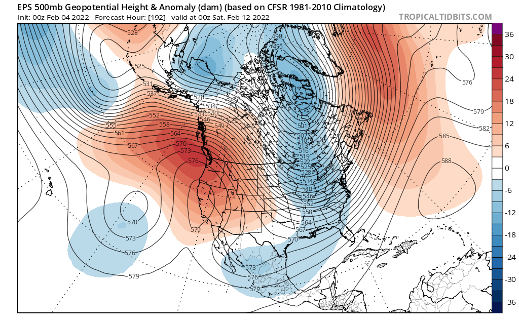
Yeah, this looks similar to the January pattern. All 3 (GEPS, GEFS and EPS) show something similar. You can see the trough axis is a bit further west than January and some signs of southern stream action too. Not hard to envision a shortwave diving out of Canada over the ridge and meeting up with something ejecting out of the SW. This upcoming week is more a reshuffle, and we get this look by late next week so it's not some day 15 fantasy, it's already under day 10.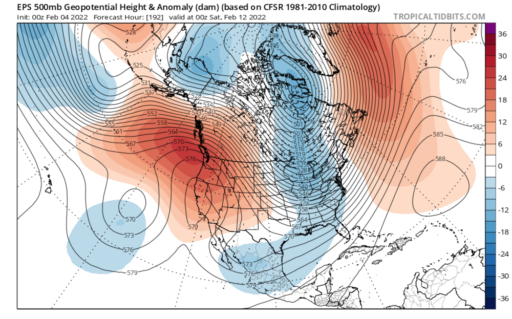
-
Western PA/Pittsburgh Winter 2021/22 Discussion
RitualOfTheTrout replied to meatwad's topic in Upstate New York/Pennsylvania
We should all give ourselves a pat on the back. Washing your laundry in cold water is environmentally friendly so I can only assume washing your car in 32.1 degree water also qualifies. TIDE approves of this message.
-
Western PA/Pittsburgh Winter 2021/22 Discussion
RitualOfTheTrout replied to meatwad's topic in Upstate New York/Pennsylvania
Looks like for the most part the advisories and warnings panned out well for the ice etc. Overall a well forecast storm, models did pretty well. GFS was to cold and aggressive pushing the front through but generally was the first to catch on that there would be some impact here once all the models had flipped way NW. I thought the 3K NAM did well with temperatures once we got 12-24 hours out. It nailed us basically sitting at 33 degrees for 12-16 hours yesterday. I didn't flip to below freezing until somewhere between 11:30-12:00am then when I checked the radar at 2am it was evident the front was progressing quicker than it had all day and the back-edge of the more steady stuff was already encroaching into OH. All that being said, for my yard nothing but a nuisance. Only thing memorable will be what could have been. 36 hours of precipitation and only 4-5 of it managed to be some sort of wintry weather. Don't get me wrong, I'm not mad I don't have to deal with power outages and cutting up fallen trees but at the same time I don't track sunny days either, I like to see the interesting and extremes and this missed by a pretty narrow margin on that metric. So what's next? lol -
Western PA/Pittsburgh Winter 2021/22 Discussion
RitualOfTheTrout replied to meatwad's topic in Upstate New York/Pennsylvania
00z NAM shows me above freezing until 11pm - 12am now. Can keeps getting kicked if that's correct. -
Western PA/Pittsburgh Winter 2021/22 Discussion
RitualOfTheTrout replied to meatwad's topic in Upstate New York/Pennsylvania
<Samuel Jackson Impersonation> Wait I'm still plain raining and you mutha f#$@ckers are flipping to sleet... What the f$#k!?!? </Samuel Jackson Impersonation> -
Western PA/Pittsburgh Winter 2021/22 Discussion
RitualOfTheTrout replied to meatwad's topic in Upstate New York/Pennsylvania
Took the trash out and it's pouring plain rain still. No ice on anything, pretty strong breeze so it feels awful. -
Western PA/Pittsburgh Winter 2021/22 Discussion
RitualOfTheTrout replied to meatwad's topic in Upstate New York/Pennsylvania
Yeah, that and typically waves riding up a front tend to slow it down. Wasn't our Christmas Eve storm in 2020 a wave riding up a boundary? -
Western PA/Pittsburgh Winter 2021/22 Discussion
RitualOfTheTrout replied to meatwad's topic in Upstate New York/Pennsylvania
Sorry, had to do it. With our track record with storms this might be my last best chance to use it this winter.
-
Western PA/Pittsburgh Winter 2021/22 Discussion
RitualOfTheTrout replied to meatwad's topic in Upstate New York/Pennsylvania
Can't hurt we are getting close to sunset either. -
Western PA/Pittsburgh Winter 2021/22 Discussion
RitualOfTheTrout replied to meatwad's topic in Upstate New York/Pennsylvania
Maybe... or maybe the heat generated from the motors sets us back 6 hours.. Do you really want to take that risk?