RitualOfTheTrout
-
Posts
3,468 -
Joined
-
Last visited
Content Type
Profiles
Blogs
Forums
American Weather
Media Demo
Store
Gallery
Everything posted by RitualOfTheTrout
-
 That's my "concern" as well, to much of a good thing if its too strong and all the storms get pushed well underneath us and off the coast. I think at a minimum though if that pattern materializes we will feel the cold, and likely see some little lake enhanced things as you say. Volatile is key, lots of pendulum swings as patterns break down / reload. Should be fun to see how it all evolves.
 -
Fall 2022 Pittsburgh/Western PA Discussion
RitualOfTheTrout replied to Ahoff's topic in Upstate New York/Pennsylvania
That is what I see being a concern with the advertised upcoming pattern. Still lots of other variables that will dictate things but seems more likely than now the trough axis will be to far east which is why coastal folks are jumping for joy. Miller Bs almost always end as slop storms when the warm air arrives sooner than anticipated or we get caught in a dryslot unless we get the perfect pass before it jumps. They can be fun though if we get a thump from the primary and lucky enough to get some love from the secondary throwing back moisture. -
Fall 2022 Pittsburgh/Western PA Discussion
RitualOfTheTrout replied to Ahoff's topic in Upstate New York/Pennsylvania
Give it a few days, we are still about a week out at least for the block / pattern change to start getting established. All we have now is a general idea of how things will look at H5. Should be interesting to see how the first storm interacts with the block. -
Fall 2022 Pittsburgh/Western PA Discussion
RitualOfTheTrout replied to Ahoff's topic in Upstate New York/Pennsylvania
I'm far from qualified to answer and to RD9108s point if coastal folks are really happy we probably see the storm track to far out to sea for any real shot. That being said, in my opinion in general if the pattern is favorable for the east coast we have a shot. If there is a monster -NAO we actually probably want a more nuetralish / slightly negative PNA as we want some SE ridging to push against the NAO to force the storm path inland. To many variables in my mind to say one specific metric is better than another for any discrete threat, things like timing of a phasing / other shortwave interactions can alter the track in ways that would make a less than optimum setup work for us or kill us. -
Fall 2022 Pittsburgh/Western PA Discussion
RitualOfTheTrout replied to Ahoff's topic in Upstate New York/Pennsylvania
The upcoming 10-12 days has been fairly well advertised as meh for any winter weather of interest in terms of discrete storm threat tracking, something little could always pop up short term but overall it looks pretty hostile. Whether the upcoming "pattern change" materializes is the real question. (Yay! Pattern tracking lol) Lots of posts seem to be proclaiming the modeled -Nao as a panacea for everything else will likely end in disappointment. I'm paying more attention to the PNA, if it's very negative the calls for big cold will fail as cold air source gets cut off and SE ridge pushes. Then again you rarely score a big storm with a huge purple temp anomaly overhead. -
Fall 2022 Pittsburgh/Western PA Discussion
RitualOfTheTrout replied to Ahoff's topic in Upstate New York/Pennsylvania
Just hit here, pretty awesome just seeing this cloud of wind whipped snow approaching in the distance. -
Fall 2022 Pittsburgh/Western PA Discussion
RitualOfTheTrout replied to Ahoff's topic in Upstate New York/Pennsylvania
Looks worth monitoring radar tomorrow morning for sure. NWS makes mention of some potential for heavier snow or even a squall. Friday will continue to be cold, Hi-Res models portray snow shower potential increasing with the passing shortwave passage from late morning through late afternoon. With reinforced cold air from the west, CAPE could increase between 20-35 J/kg and convective snow bands could hold together. Nevertheless, models indicate a very well defined vortmax associated with he shortwave moving in tomorrow morning just after 12Z with strong winds aloft. The potential certainly exists with the amount of instability present for an isolated heavier band or even a snow squall. Thus have upped snowfall amounts a tad and included all of the Ohio counties in the HWO. As well, the better agreement with the hi res models showing better instability coupled with mechanical assistance from the terrain in the southeast, the totals in the southeast were raised to 1 to 3 inches. A Special Weather Statement may be needed or even a Winter Weather Advisory. -
Fall 2022 Pittsburgh/Western PA Discussion
RitualOfTheTrout replied to Ahoff's topic in Upstate New York/Pennsylvania
Models indicating the possibility of something brewing for black Friday. Looks like a miller B type setup with low odds but if you are in the mood to track could be first threat to keep an eye on. -
Fall 2022 Pittsburgh/Western PA Discussion
RitualOfTheTrout replied to Ahoff's topic in Upstate New York/Pennsylvania
Probably a bit of wet bulbing going on here, dew points were generally 29-30 degrees when the heavier rates moved in. Nice .25 - .5 inch of wet snow, even started accumulating on shaded pavement briefly. Enough my son had to go outside and play in. First snowball fight of the season under my belt now. -
Fall 2022 Pittsburgh/Western PA Discussion
RitualOfTheTrout replied to Ahoff's topic in Upstate New York/Pennsylvania
Nice burst of fatties coming down right now. Radar looks like a heavier burst is possible, not sure if that is some sort of mix though. -
Fall 2022 Pittsburgh/Western PA Discussion
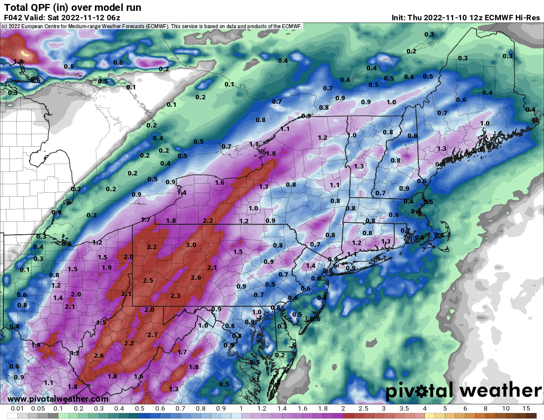
RitualOfTheTrout replied to Ahoff's topic in Upstate New York/Pennsylvania
Looks like the global models have shifted back east a bit. Short range still seems to have the heaviest access into eastern OH but either way 1.5 - 2.5 inches looks like a good bet. Euro for reference:
-
Fall 2022 Pittsburgh/Western PA Discussion
RitualOfTheTrout replied to Ahoff's topic in Upstate New York/Pennsylvania
Yeah, I'm enjoying the great fall weather, but totally ready to shift gears once mother nature decides to flip the switch. Looks like maybe a good soaking for the area with tropical remnants. Why can't we get a storm like this as all snow in winter?
-
Fall 2022 Pittsburgh/Western PA Discussion
RitualOfTheTrout replied to Ahoff's topic in Upstate New York/Pennsylvania
This has been one of the most enjoyable Fall seasons I can remember, pleasantly warm during the days with sunshine, fairly dry, and cool to cold evenings and overnights to keep it feeling like Fall. I've gotten several little outdoor projects completed I thought would be a next Spring tasks, spent lots of time outdoors, and saved a decent chunk of change on heating with minimal furnace usage. Our neighborhood Trick-or-Treat was Saturday evening, and it was probably the best since I've had kids (10+ years). Pretty Hollywood-esque scene with just past peak color contrasted on clear blue evening sky that fades to a cool crisp night. No concerns with umbrellas or trying to fit costumes over three layers to keep warm. My personal preference, but if you are going to have above average temperatures mid October - Thanksgiving-ish time frame gives the most bang for the buck. Unseasonable cold this time of year is largely useless for snow and it gives the hope the pattern needs to flip at some point. If things still look warm in another 2-3 weeks I'll start to get worried about potential wasted winter opportunities but until then I'll take this warmer weather. -
Fall 2022 Pittsburgh/Western PA Discussion
RitualOfTheTrout replied to Ahoff's topic in Upstate New York/Pennsylvania
Yeah, 12z Euro looks like some rain of consequence, especially SE of the city. GFS not so much. -
Fall 2022 Pittsburgh/Western PA Discussion
RitualOfTheTrout replied to Ahoff's topic in Upstate New York/Pennsylvania
Wonder if we manage and decent storms this evening, seems to have already gotten overcast which will probably limit instability. I'm looking forward to the cool weather for sure. Will probably close the pool for the season. Meanwhile way out in fantasy land GFS has remnants from whatever develops in the gulf taking aim at us with another shot of cold air on the backside. -
Pittsburgh/Western PA Summer 2022 Discussion
RitualOfTheTrout replied to Ahoff's topic in Upstate New York/Pennsylvania
How did everyone fair with the storms yesterday? I was in Wexford and it was pretty mild, but at home I got blasted. Tree limbs everywhere, power outage, fence was crushed by a tree in one section, garbage cans with trash bags in them blown over and the bags blown out. I’m not far from that BP that had the gas pump blown over. Must have been a microburst or something. -
Pittsburgh/Western PA Summer 2022 Discussion
RitualOfTheTrout replied to Ahoff's topic in Upstate New York/Pennsylvania
Anyone else noticing the yellow sky? Crazy how comfortable it is out there. Very odd looking sky with sunset reflecting off these clouds.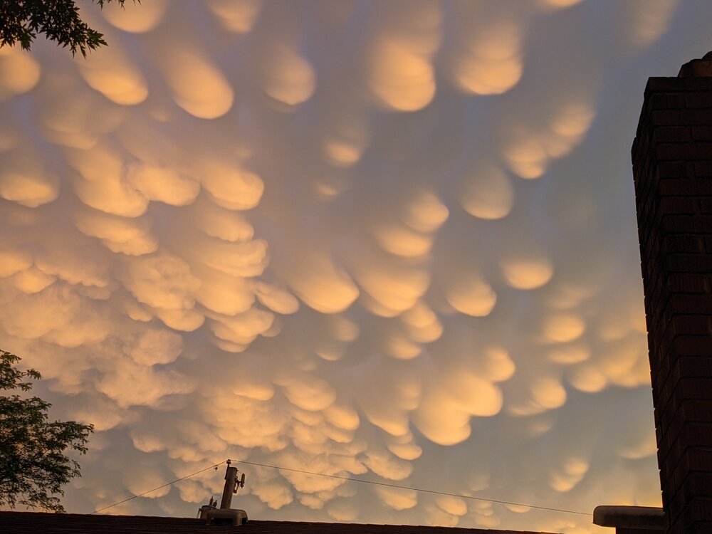
-
Pittsburgh/Western PA Summer 2022 Discussion
RitualOfTheTrout replied to Ahoff's topic in Upstate New York/Pennsylvania
Surprised not even a drop of rain. Glad I watered the garden yesterday. Central / SW OH getting blasted again. -
Pittsburgh/Western PA Summer 2022 Discussion
RitualOfTheTrout replied to Ahoff's topic in Upstate New York/Pennsylvania
Yeah whether we actually hit 90, those dewpoint numbers will make it pretty unbearable to be outside other than immersed in the swimming pool. I'll be interested to see how the severe threat sets up tomorrow afternoon / evening. Still some uncertainty per NWS which trigger is most likely to set things off. Looks like a pretty pleasant weekend on tap. -
Western PA/Pittsburgh Winter 2021/22 Discussion
RitualOfTheTrout replied to meatwad's topic in Upstate New York/Pennsylvania
Going to need elevation and some intense rates to overcome time of year during the day for much more than a coating on the grass that melts pretty quickly after. It’s going to be a raw miserable day for most I think. -
Western PA/Pittsburgh Winter 2021/22 Discussion
RitualOfTheTrout replied to meatwad's topic in Upstate New York/Pennsylvania
It has been an odd winter, by the numbers it looks good but lots of dead periods and near misses, crazy to think about. -
Western PA/Pittsburgh Winter 2021/22 Discussion
RitualOfTheTrout replied to meatwad's topic in Upstate New York/Pennsylvania
Crazy squal ripping through here right now, heavy snow probably top 5 in snow rates of the winter. -
Western PA/Pittsburgh Winter 2021/22 Discussion
RitualOfTheTrout replied to meatwad's topic in Upstate New York/Pennsylvania
Looks like a mid January morning out there rather than late March. -
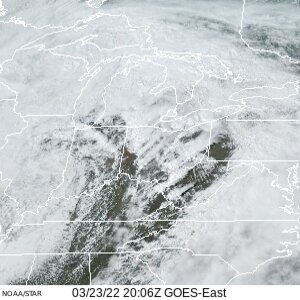
Yeah, pretty wide swath of clearing over SW PA right now. It will be interesting to see if this has any effect on thunderstorm development later in the evening.
-
Western PA/Pittsburgh Winter 2021/22 Discussion
RitualOfTheTrout replied to meatwad's topic in Upstate New York/Pennsylvania
Pretty much me this weekend: Special Weather Statement National Weather Service Pittsburgh PA 1020 PM EST Sat Mar 12 2022 PAZ013-014-020>022-073-130415- Armstrong-Butler-Lawrence-Westmoreland-Beaver-Allegheny- 1020 PM EST Sat Mar 12 2022 ...A HEAVY SNOW BAND WILL AFFECT NORTHEASTERN BEAVER...SOUTHERN LAWRENCE...SOUTHERN BUTLER...NORTHEASTERN ALLEGHENY...NORTHWESTERN WESTMORELAND AND SOUTHWESTERN ARMSTRONG COUNTIES... At 1015 PM EST, a snow band was located north of Pittsburgh and mostly stationary; 1-2 inches snowfall could occur within this band. Winds in excess of 30 mph are possible with this snow band. Locations impacted include... Cranberry, New Castle, Vandergrift, Apollo, New Kensington, Lower Burrell, Harrison Township, Ellwood City, Arnold, Tarentum, Natrona Heights, and Meridian. This includes the following highways... Pennsylvania Turnpike between mile markers 1 and 19. Interstate 79 in Pennsylvania between mile markers 81 and 96. Interstate 376 in Pennsylvania near mile marker 14. LAT...LON 4076 7971 4053 7952 4057 7982 4090 8052 4105 8052 TIME...MOT...LOC 0317Z 299DEG 45KT 4090 8036 Lol, we got snow here and it was fun sitting in the hot tub during a snow squall but totally feeling jealous missing the best snow of the season back home.