RitualOfTheTrout
-
Posts
3,468 -
Joined
-
Last visited
Content Type
Profiles
Blogs
Forums
American Weather
Media Demo
Store
Gallery
Everything posted by RitualOfTheTrout
-
 SWPA has always lacked a red tagger for the most part, at least one officially declared. We had one for a couple years with handle of NineInchNails but I think he took a Met job in TX and slowly faded away. Lots of intelligent and knowledgeable folks though through the years and our fair share of screw balls too.
 -
I remember those days back on EasternUS Wx. You did have to know where peoples location was to interpret their posts. Getting Euro data was like finding the holy grail and you always had someone trying to ask an imby question thinly veiled as something else lol. Always the love / hate on again off again relationship with DT. Sometimes I still follow along the MA threat threads as it still has a light version of that feel but you do lose that interaction with quality posters from other regions now and you can be met with some serious outsider hostility which sucks.
-
Essentially yes, he’s saying the upper level support is racing out ahead of the surface, thus it could end up further east if the models continue with that type of evolution.
-
Welcome, always glad when we get new posters to our region! I don't think ratios will be much more than 10:1. High winds tend to break up the flakes as they fall.
-
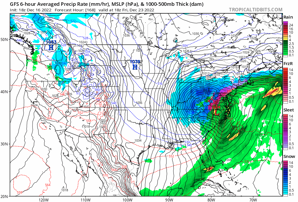
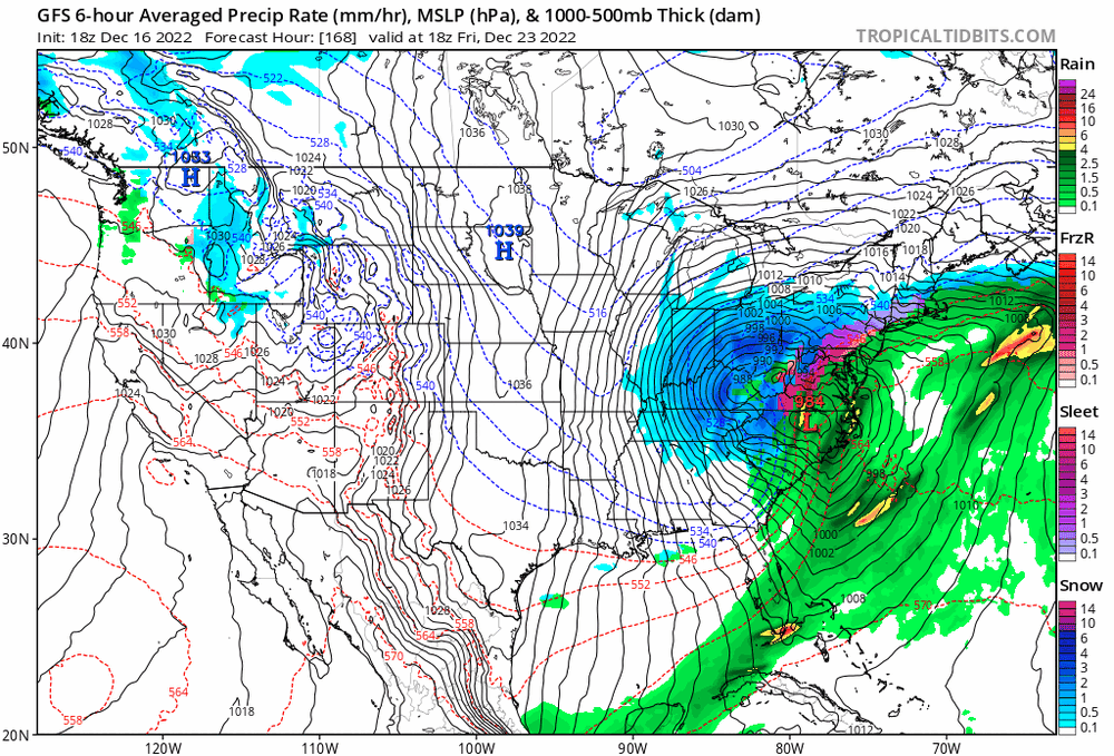
GFS 12z / 18z today both look good for track to maximize wrap around / anafrontal snow. Also looks like it has the best period of lake enhanced NW flow afterwards before going more westerly. Probably want it to bomb and occlude NE of us vs in Michigan if you want prolonged LES for us.
-
Yes, this setup doesn't have a wave riding up the front, so good to point out this is a different animal.
-
Yeah, I've kept expectations in check since it was the GFS vs the world a few days ago. At this point should still be a pretty intense change over with winds ripping too. It's clear it's going to be west, but as you said it being further NW now is probably better for our chances than a near miss. I think we should still manage a 1-3 type event if that wrap around / lake enhancement. Might even be doable to see a 3-5 inch type setup.
-
Meanwhile this upper trough moving through is setting off some moderate snow right now. Little over a quarter inch right now. Radar has a pretty healthy band showing up. These types of things are our bread and butter.
-
All 00z models look to be slightly better. As is we would have one hell of a flash freeze / abrupt change to snow. Should be some serious wind too, plus the low position in New York state would give a period of lake enhancement as it pulls away. Captain obvious but if we get a continued improvement could get even more interesting. I'm all for a clean snow event but a dynamic beast of a storm could still be fun.
-
Yeah I wouldn't give up on this yet. I doubt a full blown snow storm like yesterday's 18z GFS happens but we could still get a progression that's favorable for more than a 1-3 inch type deal we are looking at right now.
-
As of right now I don't think it's projected to last very long. Low near Alaska should shift West letting -epo re-establish. People much more up on things also think the -Nao will reload and typically strong negative -AOs like we have now bode well for reoccurring throughout winter. That all assumes models aren't breaking the colder look down to fast. Nina Winters seem to swing back and forth, I don't think anyone was saying the cold pattern would lock in until March.
-
I'll see what I can do.. lol
-
Yeah, I'll say. We all get crushed vs those sharp SE to NW cutoffs that seems to happen with the bigger storms lately. It was weaker with the confluence with a tad more energy held back which is a nod towards the CMC / Euro camp. It's not clear whether some sort of meeting in the middle with respect to that happens or if we see an all out whiff / cave to one idea or the other yet.
-
So it was written so it shall be done.
-
I'm going to throw out some Christmas optimism.. but let's just imagine if say there is an 80/20 split between GFS and the rest of the models by way of having a weaker piece stretch / break-off and get caught under the block but enough to keep it from cutting way west and this beast bombs and crawls just east of the spine of the apps.
-
I agree, could still go down the toilet but most solutions get us some snow. Not being an all or nothing deal takes some of the edge off so tracking is fun.
-
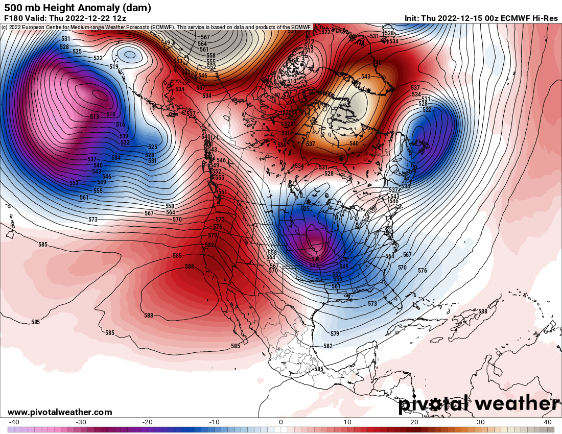
I don't have a real solid feeling one way or the other on this right now. The ridge axis is further east out west and the confluence from the low trapped under the block is stronger and we don't see a clean phase on the 12z runs today so that makes North and East closer to the coast areas favored. Whether we see enough changes in any of those to get a bigger impact storm here or that the trend continues the other way is anyone's guess.
-
Who knows, GFS used to be somewhat better in some instances with northern stream stuff because that bias played into the fast flow that we usually see. To be honest though the models go through upgrades much more frequently and I haven't kept tabs on what the tendencies are. I thought the Euro went through an upgrade somewhat recently that was going to help its tendency to hold energy back for example so I have no idea whether to consider that when looking at any given output anymore. I'd be curious to hear from a MET or someone with more knowledge what the prevailing opinion is these days.
-
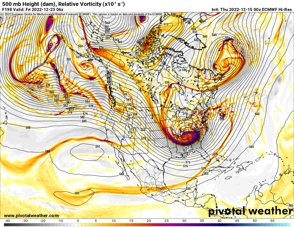
00z Euro... if you could hear graphics on the internet it might sound like... JAWS THEME Really just a matter of timing the phase if the rest of this was accurate. Ridge axis out west is in pretty good spot. Just doesn't quite get consolidated / phased in time and we just miss. Wouldn't take much change in timing of the shortwaves to get this going sooner. Even with that said its a decent storm on the Euro for us, but northern PA / Upstate NY gets absolutely blasted on this run. My gut says Euro is probably over doing things and still to far out to assume anything is set but as rarely as we get hit with a storm even having some maps to parse for something big isn't that common, imho next to watching the snow fall this is the next most fun part.

-
Should be doable even if it's just an inch or so from the arctic front. I'm pretty liberal with my definition of a white Christmas, half inch of snow the day before and cold air will do if that's all we can manage. Beats 40s and brown mud right?
-
With that low being all the way in Wisconsin WAA won't be as strong however we still lack an in place cold airmass and high to the north to replenish low level cold to offset latent heat release. Those ice maps just look at any precip that falls with surface temperatures at 32 or lower and say its ice accretion. You won't see much accretion at 31.9 with light / moderate rain. I agree, unless we really see a trend towards colder air most of what we see in Allegheny county will be rain. Still could be a dicey period as it only takes a slight glaze to cause a big problem on the roads, but a big ice storm like the NAM shows isn't happening for SWPA lowlands.
-
I guess I'm still focused on how the pattern develops after this storm. Always a chance but the storm has a lot going against it for us. Looks like essentially a late developing miller b with no real antecedent cold to start off.
-
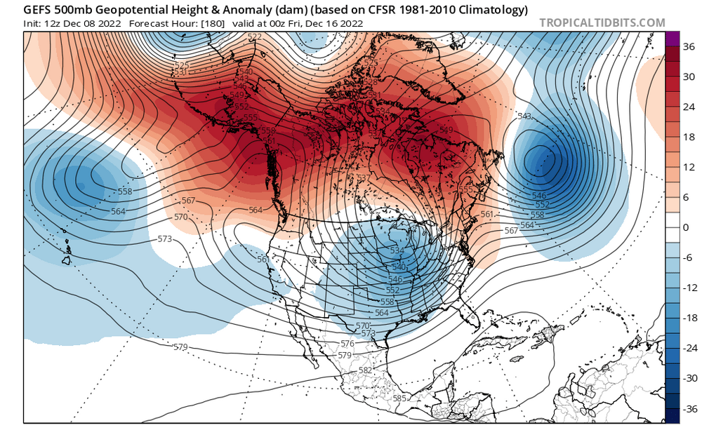
I think we are in a fool me once shame on you full me twice shame on me mode and want to see how things evolve before getting to invested. Global ENS all seem to be agreeing we get a -EPO to start dumping cold into the West / Central US with a -NAO and somewhat less hostile PNA. It will take a cutter or two to drag some of this east but there will be cold close enough to tap. Best part is the changes are evident under the day 7-8 period while models still have reasonable skill. I could see some slop storms with systems trying to cut, hitting the block and redeveloping with this setup. Having that trough around Hawaii usually teleconnects to some ridging in the west and a trough in the east. How long it lasts / what it morphs into is way beyond my skill but if this comes to fruition we should see storms with at least some frozen popping up soon.
-
Yeah, I think we are seeing some solid evidence of Jwilson's statement earlier saying some sort of +PNA is the most important metric being correct, at least for early season. You can have the biggest -NAO but if there is zonal flow off the pacific you just block in mediocre airmass. Some of those earlier looks with the PV lobe blocked under the -NAO and the solid +PNA had me worried about suppression and had that verified verbatim we probably would have saw a few storms to far South, but the look has degraded so much aside for some -NAO we are hardly looking at the same pattern now. Definitely need some pacific help but seems we keep seeing that get pushed out. Further we get into the season the more our odds increase for some fluke event. Even if we can manage to get some -EPO to dump cold out west we can get a transient cold shot behind a storm and maybe time something up.
-
Who knows, still far enough out it may not end up like all these “epic” looks the models have been spitting out.