RitualOfTheTrout
-
Posts
3,468 -
Joined
-
Last visited
Content Type
Profiles
Blogs
Forums
American Weather
Media Demo
Store
Gallery
Everything posted by RitualOfTheTrout
-
 We've had so many wind advisories this winter. Should have traded my snow shovel in for a fancy kite.
 -
There's still 2-3 weeks left, wouldn't shock me if we managed to beat that 2.2. Heck, even April would have an outside chance with such a low bar. If we can't get a 6+ event at this point I'm good with futility lol
-
Glad I never got to involved in this one, it looked good for a couple days but the GFS being on its own NW was a red flag mainly due to the fact it was showing the storm follow what we've seen all season. Now I hope it cuts as far NW as possible, give us a dry slot and maybe another nice day in the 60s.
-
Figures, there were a few times this season the GFS was an outlier for a good setup for us and it caved to the others.
-
At least it's falling apart before much investment. Still worth keeping an eye on for now. I figured NW was a more likely fail given the seasonal track, not sold it's a done deal yet.
-
Yeah some decent hits on the ENS. 18z GFS a bit better looking than 12z.
-
Still has a storm, no way you should expect that exact same evolution 4 times a day 7 days out. Take home is our area is still between the goal posts of operational / ensemble suites for some type of winter weather. I get patience is low given we just went a month with legit nothing. A large area of real estate in the east is hoping this is the storm for them but inevitably there's going to be disappointment somewhere. For now just enjoy the track knowing we are still in the game.
-
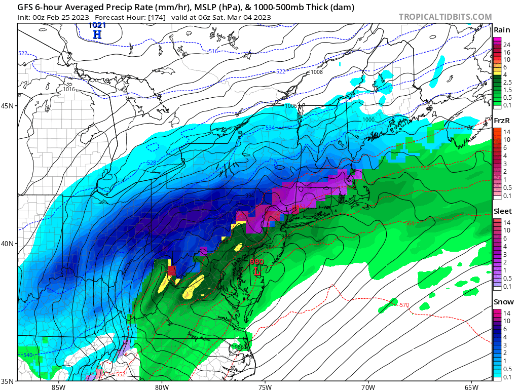
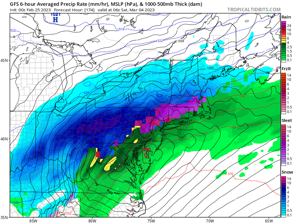
00z says hold my beer...
-
Wow.. meanwhile Canadian has it snowing in NC lol. That would probably be some of the heaviest snow rates I can recall on a model. Now off to bed, really has to be downhill from this!
-
Fun to see, but still a ton of spread. GEFS have a lot of members with a pretty wound up cutter. But hey, 26 inches gets us to almost normal snowfall for the season so I say bring it!
-
March snow.. especially after a season like this one.. Go big or go home! Probably the best run all season (not saying much) but after a month of only checking models once every other day I've been checking in daily on this one, might have to up that frequency if we actually have a shot at something here.
-
Pretty good burst of snow under some of these bands. Nice interlude of winter during our perpetual spring weather.
-
It can't be 100% attributed to any one storm or season. Climate change will make bad patterns even worse, ie to your data points maybe 100 years ago a bad winter pattern would yield 5 inches of snow on the season and 2 70 degree days, but now its 2 inches of snow and 6 70 degree days. This pattern would suck in any era relative to normal. Does climate change play a role in making these "bad" patterns more frequent or make the "good" ones less effective? Does it make past analogues with a marginal setup where we just squeaked by at 32 and had heavy snow now more likely to be an all out fail? Does it further reduce other forces that might mitigate a bad situation to make it workable for snow? Probably, but its going to take decades to see that trend in the data. It's even likely that we see some sort of "sweet spot" were warmer more moisture laden atmosphere meets up with still cold enough planet to increase our snow averages. Maybe we are in that now, or getting to the tail end when its more likely going to be to warm, no way to know yet. Admittedly I'm basing that on the idea that the change will be slow, at least relative to the scale of a human lifetime. Maybe that's wrong and once we get past a certain point exponentiation deterioration will rapidly put an end to winter weather in our area. Point is I'd need to see several years to say this season is anything close to a "new normal".
-
I generally agree, Nina climo always favors a SE Ridge in Feb, this is the third year in a row for a Nina. I don't doubt warming climate / oceans hurt chances but to me this is just many different things constructively interfering with each other to produce a terrible pattern for snow in the East. The caveat I will add to this though is it remains to be seen when / whether we reach a tipping point where the warmer oceans favor tropical forcing / ridge / trough configurations that make these conditions more likely during winter. Only way to know will be to live through it, if we get a favorable ENSO state and things still look like this well then maybe its time to re-think. Went for a walk earlier and its wonderful. We can maybe make a run at 70? Just wish I wasn't at work so I could get some outdoor things done at home.
-
I have to admit one of the best parts of tracking is when we are all collectively tracking together and the storm starts trending better as we close in. I'm on the edge of my seat refreshing the model pages as excitement builds and you can't keep up with the new posts. That and when a storm hits and we are all posting obs of heavy snow etc. Really missing one of those right now. Still looks like maybe a shot at some wintry weather this weekend, better than 50s and rain I guess.
-
All 3 00z runs had some sort of secondary wave develop for the weekend. Highly timing dependant for where it tracks. 06z GFS for example gets it going to late / North. It's our best shot at something, need it to track close enough behind the initial storm during the week while heights are suppressed in the east, but not amplify to soon / late since we aren't getting any help. Really the proverbial thread the needle setup.
-
Dang, think somebody needs to replace the cyan toner in the 18z GFS.
-
Same, not much, but love snow falling while it's like 12 degrees out.
-
Yeah it is, 14 degrees now. The wind really cuts right through you, especially when our bodies are more accustomed to 30s and 40s. I happened to wake up right around 2:30am and catch the front coming through and the snow falling, could really hear the wind howling. Probably picked up a quarter inch or so but looked wintry at least for awhile. Now see who / if anyone gets lucky enough to maybe get under a lake band and pick up some extra snow. Looks like we will have a Huron connection for awhile, but other variables not favorable for better coverage. This cold snap is so quick though, midnight high today, and making it back close to 30 tomorrow it will largely be lost in the history books outside of overnight lows. Outside of that, the next 7 days looks pretty uneventful, maybe another cool / cold shot past that. Pattern looks pretty meh for any sustained winter. Still a solid 6 weeks to cash in on something.
-
Yeah, radar looks decent, hoping those returns make it into Westmoreland. 00z models seemed to improve slightly too with precip making it further in SW PA. Just a slushy dusting so far here, but if we can drop the temp another degree or two and get some better rates shouldn't have an issue accumulating.
-
Already flipped to snow here, so barring one of those situations were there isn't sufficient crystal growth shouldn't be much issue with freezing rain / drizzle. We don't usually get ZR when a cold front drops temps, at least anything prolonged. Much more likely warm air overriding antecedent cold. As for the inch... Well think it will be a challenge but possible.
-
If this is real we need some others to jump on board. GEFS had a few similar looks, Euro was in North Carolina so something will have to give lol.
-
Really can't argue it's getting warmer at least compared to recent recorded history, normal temperatures are increasing, sea ice decreasing, ocean temperatures setting yearly records etc. That being said I'm of the opinion this year would have been bad in any era, just maybe not this bad. If we start stringing years with favorable patterns together and strike out plus warmer than normal I'll start to wonder if we've passed some sort of tipping point. I expect next season will be better. I haven't given up on getting a storm, but don't expect we can salvage any snow on snow cold weather. This upcoming week looks colder but dry, and the cold is in and out then all indications SE ridge torch again til at least the end of Feb by which time that deep winter feel isn't likely with sun angle, longer days, and return of birds singing.
-
Looks like GFS and CMC are keying in on slightly different waves or just timing differences but yeah probably not a big storm but I'd love to get a solid 2-4 / 3-6 type event without temperatures issues. It's all about timing of the short waves / strength combined with that PV lobe placement, I'd expect significant changes one way or another over the next few days one way or the other. Given the way this winter has gone especially I'd rather be looking for it to come North than praying nothing changes over the next 5-6 days.
-
Picked up a fresh inch or so after I went to bed last night, must have been a pretty isolated band though because about 5 miles down 28 there wasn't much. Pretty wintry morning, actually had to brush the cars off etc.