RitualOfTheTrout
-
Posts
3,468 -
Joined
-
Last visited
Content Type
Profiles
Blogs
Forums
American Weather
Media Demo
Store
Gallery
Everything posted by RitualOfTheTrout
-

Pittsburgh, Pa Winter 2023-24 Thread.
RitualOfTheTrout replied to meatwad's topic in Upstate New York/Pennsylvania
Both GFS and Euro show a secondary wave popping along the front, certainly worth keeping an eye on. As with anything timing is everything, but if the low deepens at our latitude after the front passes it could be fun. Pretty sure we had a storm do that a few years back on Christmas Eve. -
Pittsburgh, Pa Winter 2023-24 Thread.
RitualOfTheTrout replied to meatwad's topic in Upstate New York/Pennsylvania
So can I count that hail I got as a trace for frozen or... -
Pittsburgh/Western PA Fall 2023 Discussion
RitualOfTheTrout replied to Ahoff's topic in Upstate New York/Pennsylvania
Most of the long range forecasting (heck even short range) is above my pay grade, but I certainly don't hate the look currently advertised heading into mid December. At least right now, its not a shutout pattern, several chances of at least some snow on various ENS runs. Past that, nino climo would tend to favor increasing chances for winter weather heading into January and February. I'm at least cautiously optimistic for the winter as a whole at least hitting the average bar, with above average likelihood of some more frequent big storm tracking, whether we cash in of course tbd. -
Pittsburgh/Western PA Fall 2023 Discussion
RitualOfTheTrout replied to Ahoff's topic in Upstate New York/Pennsylvania
Getting under a pretty robust band right now, nice to see snow flying. -
Pittsburgh/Western PA Fall 2023 Discussion
RitualOfTheTrout replied to Ahoff's topic in Upstate New York/Pennsylvania
Starting to look like maybe a pretty solid cold shot around Thanksgiving. Put xmas lights up today in the beautiful weather. Fingers crossed that doesn't jinx the cold coming. -
Pittsburgh/Western PA Fall 2023 Discussion
RitualOfTheTrout replied to Ahoff's topic in Upstate New York/Pennsylvania
I like the house cool at night, but its been a bit of a challenge even with a box fan in the window to keep it 70-68 over night. I also like to see how long I can run without needing AC or Heat, got a decent streak going, but its looking like odds favor warmth next week. -
Pittsburgh/Western PA Fall 2023 Discussion
RitualOfTheTrout replied to Ahoff's topic in Upstate New York/Pennsylvania
Yeah, Im enjoying this. No heat or air needed as an added bonus. Not mad about nissing that tropical over the weekend either, but Id be crying in December at that cutoff. -
Pittsburgh/Western PA Summer 2023
RitualOfTheTrout replied to Ahoff's topic in Upstate New York/Pennsylvania
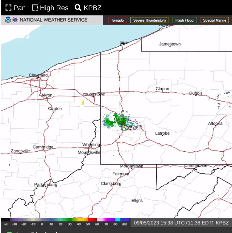
Wonder what is showing up on PBZ radar? Pretty sure it's not raining. Some sort of malfunction?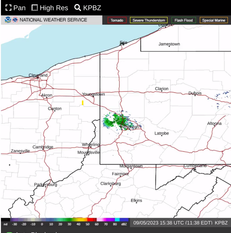
-
Pittsburgh/Western PA Summer 2023
RitualOfTheTrout replied to Ahoff's topic in Upstate New York/Pennsylvania
At least the initial batch looks to stay south. Cloud cover from that convection probably also helps us out a bit, but not 100% sure we miss everything based on some short term models showing at least a few sporadic cells before the front comes through. -
Pittsburgh/Western PA Summer 2023
RitualOfTheTrout replied to Ahoff's topic in Upstate New York/Pennsylvania
Yeah, these guys need to take this talk to a place thats appropriate for weather talk. -
Pittsburgh/Western PA Summer 2023
RitualOfTheTrout replied to Ahoff's topic in Upstate New York/Pennsylvania
Yeah, The line is weakening pretty quickly now, that probably saved us from the worst winds, but rain and lightening show did not disappoint. -
Pittsburgh/Western PA Summer 2023
RitualOfTheTrout replied to Ahoff's topic in Upstate New York/Pennsylvania
Pretty rare to be in enhanced risk area. Wouldn't mind seeing some boomers, but I hope we escape any major damage if the threat materializes. -
Pittsburgh/Western PA Summer 2023
RitualOfTheTrout replied to Ahoff's topic in Upstate New York/Pennsylvania
Found tonights NWS discussion to be confusingly entertaining. .SHORT TERM /6 AM FRIDAY MORNING THROUGH SUNDAY NIGHT/... The surface trough will not swiftly pull away Friday as its fearless progression slows in an attempt to occlude and collocate under the upper low. If you are concerned about rainfall, we will take a moment to speak now on it: upper-level dry air reinforcement behind the cold/occluded front should limit high- QPF rainfall into the day. With showers only resulting from a reinforcing shot of cold air aloft overriding higher humidity surface conditions following diurnal temperature trends, our precipitation deficit will stay in the red. So far, we are 0.66 inches short of our mid-month average rainfall. While we will not have the driest June on record, we will certainly not match the record 10.29 inches the area received in June of 1989. Though the region has had a recent reputation of being dry, shower activity will persist in Pennsylvania and West Virginia through the afternoon, with the best shortwave- enforced ascent. If you are a dry weather lover, good news! Friday will not be a washout, with only isolated to scattered showers decreasing toward evening as the trough pulls away. This un-notable weather will not go down as folklore, with dry and typical conditions returning evermore (or at least until next week). There is moderate to high confidence in dry conditions late Friday evening through midnight for anyone who may happen to be outside for one reason or another. There is high confidence that the upper trough develops into a closed low over the weekend over the northeast. This will return north-northwesterly flow aloft, and stream down drier Canadian air. An approaching surface high will leave conditions pleasant over the weekend with mostly clear skies and seasonable temperatures. -
Pittsburgh/Western PA Summer 2023
RitualOfTheTrout replied to Ahoff's topic in Upstate New York/Pennsylvania
Smoke is pretty intense for sure. Made for a really bright orange view of the sun. Almost looks like it's foggy out, but its smoke. Trying to get over a respiratory cold and I can definitely feel it making it harder to breath. Normally I don't notice anything different during these air quality alerts, so must be the combination of the two.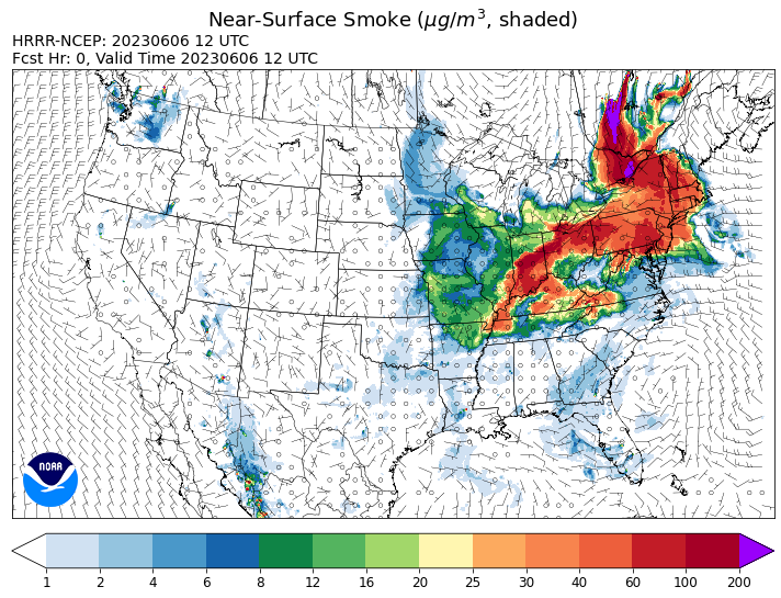
-
Pittsburgh/Western PA Spring 2023 Discussion
RitualOfTheTrout replied to Ahoff's topic in Upstate New York/Pennsylvania
Its been absolutely gorgeous, but going to need some rain here pretty soon. Noticing some lawns are starting to get that late July / early August look with some brown spots showing up. I was wondering about the dew points, pretty low for the time of year for sure. That map of nearly 0 qpf for 384hr is pretty rare in and of itself especially added onto the streak we are already on. -
Pittsburgh/Western PA Spring 2023 Discussion
RitualOfTheTrout replied to Ahoff's topic in Upstate New York/Pennsylvania
Next 5-7 day period shaping up to be pretty lousy for sure. Would like to see this type of pattern setup in winter, periodic snow chances via ripples of energy rotating around that cutoff low taping into some lake enhancement. -
Pittsburgh/Western PA Spring 2023 Discussion
RitualOfTheTrout replied to Ahoff's topic in Upstate New York/Pennsylvania
Looks like worst of this is just NW of the city, in those stronger storms. -
Pittsburgh/Western PA Spring 2023 Discussion
RitualOfTheTrout replied to Ahoff's topic in Upstate New York/Pennsylvania
Couple of weakish convective showers rolled through, but also tapped into that wind potential. If anywhere manages to get a stronger storm things could get real with the wind. -
Should be interesting to watch this snow squall potential develop today. Time of year should help boost instability by the time it gets to our area.
-
Beautiful wintry evening for sure. Steady light snow now for past hour with little brief heavier bursts. Starting to accumulate on the roads now. Have to admit I was surprised snow lasted on the ground all day despite sun angle.
-
Euro is a perfect track / scenario for us, we've hardly had any fantasy hits this year so fun to see I guess. That would qualify as my paste bomb. Euro has been pretty flaky this season and its probably over amplifying it. Upstate NY has been doing pretty good, at least lately. Makes me wonder if 30 years ago that would have been our area getting slammed, or not I still think this season would probably have been lousy in any era.
-
Likely to tack on a little more today too with the snow bands. Looks and feels pretty wintry out there, not quite the same feel as when it happens in mid winter, but take what you can get especially after Feb. Quickly looking through the models potential is there for more snow. I count at least 1-2 more storms that might affect somewhere in the east. Climo will be rapidly fading soon though so anything lighter would have to be at night or get a paste bomb during the day.
-
It has been pretty horrid. March is shaping up to be essentially what I really didn't want to happen. If only we could have swapped Feb and March patterns probably would have had a decent Feb, then we could jump right into a nice warm spring. Instead March is colder than Feb, but not quite cold enough for meaningful snow, just more dreary / damp / cool weather. I mentally accepted this wasn't going to be a good year half way through January and checked out, did what I could outdoors with relatively nicer weather, especially those 60s and 70s in Feb. Only checked models every couple days except for those couple teases we had. If I were younger probably would have struggled more. I doubt this will be our winters going forward, but expect these types of seasons may become more common. Winter 2022-2023 will probably be best summarized / dealt with as the quote frequently repeated from Gandalf in Lord of the Rings: I wish it need not have happened in my time," said Frodo. "So do I," said Gandalf, "and so do all who live to see such times. But that is not for them to decide. All we have to decide is what to do with the time that is given us.”
-
Good info, I never really put much thought into the accuracy of past records, but this really makes you take some of those with a grain of salt. Thermometer outside of a window or roof mounted, varying degrees of elevation, location changes, and probably less than standard snow measuring techniques all paint the picture that snow totals where probably a bit higher in some cases, and temperatures were probably colder but basing current observations on those somewhat flawed recordings smooths over some the overall changes towards warmer for our region.
-
I'm not buying it either, get it under day 7 and my interests will perk up. Part of me hates to see that below avg temp map for Match, but if we can get a storm of consequence I'll be all in. March can spawn some real beasts as we know.