

RitualOfTheTrout
-
Posts
3,468 -
Joined
-
Last visited
Content Type
Profiles
Blogs
Forums
American Weather
Media Demo
Store
Gallery
Everything posted by RitualOfTheTrout
-

Pittsburgh, Pa Winter 2023-24 Thread.
RitualOfTheTrout replied to meatwad's topic in Upstate New York/Pennsylvania
Thats actually fairly responsive, usually you don't see comments on the recent model runs that soon. Would be nice to see things keep improving, even if only marginally until game time. -
Pittsburgh, Pa Winter 2023-24 Thread.
RitualOfTheTrout replied to meatwad's topic in Upstate New York/Pennsylvania
Well I took my outside Christmas lights down today. I've been waiting to get another snow cover to see them but figured I might as well get it put away. So y'all can Thank me when your watching heavy snow tomorrow. -
Pittsburgh, Pa Winter 2023-24 Thread.
RitualOfTheTrout replied to meatwad's topic in Upstate New York/Pennsylvania
I agree 100% with this, alter any of these variables slightly combined with timing of different shortwaves (all within acceptable model error) and things will look totally different, not necessarily bad different, but minor changes can have big effects down stream. I think folks forget those minor changes (errors) grow exponentially with time. When you are trying to nail down where a 100 mile stripe of heavy snow will hit it makes all the difference even though the 500mb pattern was mostly correct at day 10+. Your efforts are appreciated, even if this specific solution evaporates. We need more types of discussion like this in our area imho. If the pattern ends up similar to what is advertised there will be a storm of some type in that time frame. I think my biggest concern for failure is if that trough in west is really deep, -PNA flexes the SER to much and we end up on the wrong side of the boundary. -
Pittsburgh, Pa Winter 2023-24 Thread.
RitualOfTheTrout replied to meatwad's topic in Upstate New York/Pennsylvania
If only someone would tell us when we are living presently in the "good ole days". Its a no wonder my brain is skewed as to what to expect in winter being 12-16 years old through that time period. Epic storm in early January, I'd kill for that now. Thanks for that bit of nostalgia, true SW PA bullseye there. I recall arguing with my friend on the phone that night after seeing the snow totals map Joe had up, my friend thought we were getting that much more on top of what had already fallen lol. -
Pittsburgh, Pa Winter 2023-24 Thread.
RitualOfTheTrout replied to meatwad's topic in Upstate New York/Pennsylvania
Yeah, I'd "expect" after they digest today's 12z runs, a more detailed forecast discussion will be issued assuming there is much of anything to discuss for our area outside of snow showers mixing with rain... This thing morphing to a late blooming miller A type storm with a track a bit to far east isn't doing us any good. I'd expect if we are going to see maybe a little faster deepening or wobbles to the NW in track which would help us squeeze something out of this that would also start today if it's going to happen. 6z Euro looked a little better, but I think we are really looking at trying to scrape together a 2-3 inch type event at this point at best. Either way, outside of the mountains in central PA, totals aren't super impressive, it's not like we are getting fringed on some blockbuster storm here if it doesn't work out. Long range still looks good for opportunities as we go through January. If I had a concern it would be we keep seeing lake cutters on the operational runs. I'm hoping energy doesn't get stuck in a deep trough out west pumping an eastern ridge that the ENS means are smoothing over. -
Pittsburgh, Pa Winter 2023-24 Thread.
RitualOfTheTrout replied to meatwad's topic in Upstate New York/Pennsylvania
The upcoming storm the Miller B Primary jump to the coast is still there, albeit the primary is very weak. The whole thing is trending weaker and faster. Sure there will be a narrow stripe of winners but not really the impressive widespread impact storm that was modeled a couple days ago. True Miller A's I agree, they need to be well defined and take an inland track with a mature CCB to transport moisture off the Atlantic over the mountains by the time the reach our latitude. -
Pittsburgh, Pa Winter 2023-24 Thread.
RitualOfTheTrout replied to meatwad's topic in Upstate New York/Pennsylvania
Extrapolation of the NAM, the last refuge of a scoundrel Pittsburgh Snow lover. -
Pittsburgh, Pa Winter 2023-24 Thread.
RitualOfTheTrout replied to meatwad's topic in Upstate New York/Pennsylvania
You must be a blast at parties. -
Pittsburgh, Pa Winter 2023-24 Thread.
RitualOfTheTrout replied to meatwad's topic in Upstate New York/Pennsylvania
Maybe that strong Midwest low on the 9th will end up weaker / more progressive too and we can squeeze something out of that in the form of a front end thump to mix to dryslot. Not the most fun storms, but better than a driving rain storm. -
Pittsburgh, Pa Winter 2023-24 Thread.
RitualOfTheTrout replied to meatwad's topic in Upstate New York/Pennsylvania
I agree, what was Joe Denardo rule of thumb, closed low at 700mb for our area to see 6 or 8 + storm? In my head based on the setup 6 was probably the high end even in the better case scenarios a few days back, but now it's just an open wave that is being modeled more and more progressive. Those are almost always lower vs what was modeled anyways in terms of totals. If this truly does outrun the NS and ends up being only the southern low, the track of that is going to be to far SE for anything meaningful here. -
Pittsburgh, Pa Winter 2023-24 Thread.
RitualOfTheTrout replied to meatwad's topic in Upstate New York/Pennsylvania
Id say let it play out another 48 hours before throwing in the towel. We've been on the other side where it starts trending better then goes the other way. -
Pittsburgh, Pa Winter 2023-24 Thread.
RitualOfTheTrout replied to meatwad's topic in Upstate New York/Pennsylvania
You can even see hints of all three jets at play, and with that block if you got some phased up storm (dare I say Tripple Phaser lol) there's a good bet it gets forced to go under the block. -
Pittsburgh, Pa Winter 2023-24 Thread.
RitualOfTheTrout replied to meatwad's topic in Upstate New York/Pennsylvania
12z GFS and CMC are fairly close in the depiction, both as you said get the primary into WV now vs GFS at 00z was further South. A lot of nuances on where the best place for the transfer to happen is, but that's getting to close for comfort. -
Pittsburgh, Pa Winter 2023-24 Thread.
RitualOfTheTrout replied to meatwad's topic in Upstate New York/Pennsylvania
Generally the look with the primary not making it into OH and now rather into Kentucky is much better for our chances. At least right now the warm tongue is held at bay but we also avoid the dryslot that tends to setup between the two lows during the transfer. It's a fairly narrow stripe for victory in the grand scheme of things and there is still enough uncertainty with evolution that this could go haywire for us, but its been somewhat refreshing to see generally the same look on both the GFS and Euro for a couple runs. -
Pittsburgh, Pa Winter 2023-24 Thread.
RitualOfTheTrout replied to meatwad's topic in Upstate New York/Pennsylvania
Probably best run yet I'd say. -
Pittsburgh, Pa Winter 2023-24 Thread.
RitualOfTheTrout replied to meatwad's topic in Upstate New York/Pennsylvania
Overall looks like less northern stream energy phasing in. If that continues its going to slide off the SE coast. Plenty of time to see where this goes on future runs. -
Pittsburgh, Pa Winter 2023-24 Thread.
RitualOfTheTrout replied to meatwad's topic in Upstate New York/Pennsylvania
Yep, its an improvement. Happy New Year everyone!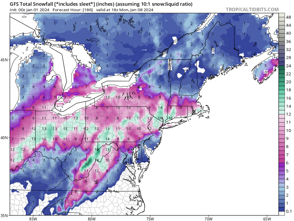
-
Pittsburgh, Pa Winter 2023-24 Thread.
RitualOfTheTrout replied to meatwad's topic in Upstate New York/Pennsylvania
Anyone getting snow? Radar showing some decent returns in some areas. Mostly rain imby so far today, but temp is starting to drop. -
Pittsburgh, Pa Winter 2023-24 Thread.
RitualOfTheTrout replied to meatwad's topic in Upstate New York/Pennsylvania
I think the point is there are other parts of the board specifically for that discussion. -
Pittsburgh, Pa Winter 2023-24 Thread.
RitualOfTheTrout replied to meatwad's topic in Upstate New York/Pennsylvania
Verbatim its more snow at one time than we've had in a year so Ill take it, but a clear signal for mixing. Like to see that primary jump a little sooner as we know the warm nose is often underestimated. -
Pittsburgh, Pa Winter 2023-24 Thread.
RitualOfTheTrout replied to meatwad's topic in Upstate New York/Pennsylvania
I like where we sit, GFS and Euro ops get the primary a bit far North I think right now but decent signal for sure. -
Pittsburgh, Pa Winter 2023-24 Thread.
RitualOfTheTrout replied to meatwad's topic in Upstate New York/Pennsylvania
Indeed, still far enough out it could change pretty drastically, some of the individual ensembles barely had a storm or were pretty far east. The Thursday storm needs to get resolved before Id get excited. Just nice to have a legit potential storm, something to give a distraction from post holiday return to work depression lol Im really looking forward to the next time we get something to track and it keeps looking better and better as we close in. -
Pittsburgh, Pa Winter 2023-24 Thread.
RitualOfTheTrout replied to meatwad's topic in Upstate New York/Pennsylvania
Things still look on track for a possible storm on the 7th. -
Pittsburgh, Pa Winter 2023-24 Thread.
RitualOfTheTrout replied to meatwad's topic in Upstate New York/Pennsylvania
I agree, the pattern is changing, but that doesn't guarantee a storm, but we should at least have some chances.That 6th-7th storm bares watching for sure. Also maybe a lighter event prior if we can get cold enough. -
Pittsburgh, Pa Winter 2023-24 Thread.
RitualOfTheTrout replied to meatwad's topic in Upstate New York/Pennsylvania
Its been awful for sure, second least snow for a calendar year on record. Its a low bar, but gotta think we do better between now through mid March.


