RitualOfTheTrout
-
Posts
3,473 -
Joined
-
Last visited
Content Type
Profiles
Blogs
Forums
American Weather
Media Demo
Store
Gallery
Everything posted by RitualOfTheTrout
-
Just making my way through the comments now, lots of reports / pictures of some pretty crazy stuff out of New Kensington. At least I know I wasn't seeing things lol.
-
Not going to complain about missing a tornado. Lol Still not sure what we saw. The clouds were moving so fast on approach so maybe it was an illusion of perspective or something, but it sure looked like a very broad area of rotation high up in the approaching cloud deck. Won't forget this one for awhile!
-
That cell that just went through here just got warned for tornado... Not suprised. My son and I were watching the cloud deck approach and I swear it looked like we could see the clouds rotating, or almost moving perpendicular to the storm morion, then all hell broke lose. May have just dodged a bullet.
.gif.5c23b980f5ece0af1190a3ca4a0cde6b.gif)
-
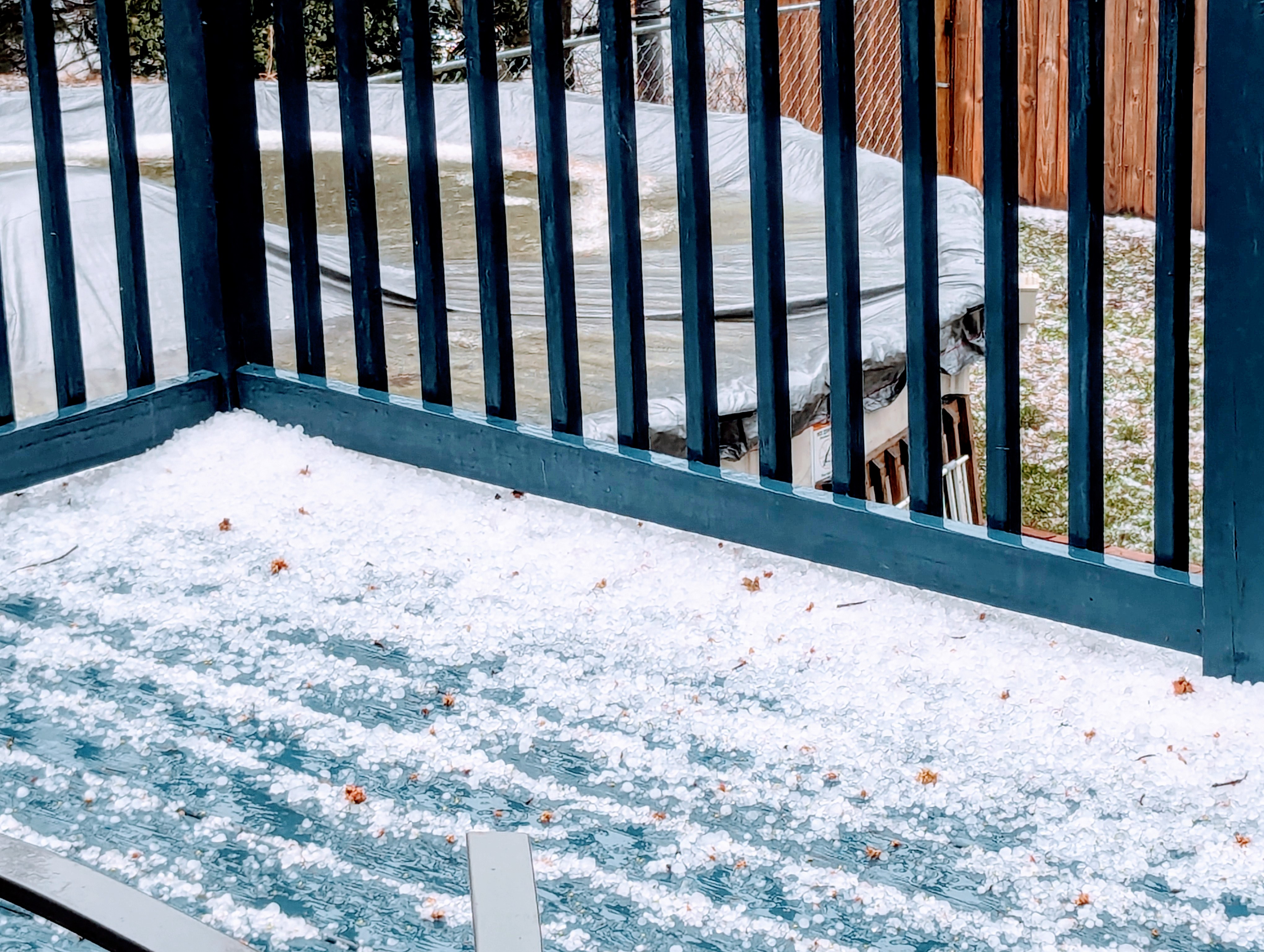
Thats a negative.. about 60 seconds of insane wind and hail, complete white out. That was intense. I thought the windows were going to get blown out. We don't typically get hit straight on like that.

-
Odd cloud movement with these storms. In-between two bands, getting some light rain now. May be enough to take some of the bite out of the main line, but time will tell.
-

Pittsburgh/Western PA Winter 2024-2025 Thread
RitualOfTheTrout replied to Rd9108's topic in Upstate New York/Pennsylvania
Most of sliding just to south of me, still had a enough to get a coating. Looks like some pretty good returns in western Allegheny. -
Pittsburgh/Western PA Winter 2024-2025 Thread
RitualOfTheTrout replied to Rd9108's topic in Upstate New York/Pennsylvania
Coating on the grass here with light to moderate wind driven snow. -
Pittsburgh/Western PA Winter 2024-2025 Thread
RitualOfTheTrout replied to Rd9108's topic in Upstate New York/Pennsylvania
Yeah, it seems like lately our region is divided on bigger storms. That Jan 94 storm track was perfect. Really an unusual distribution of snow. -
Pittsburgh/Western PA Winter 2024-2025 Thread
RitualOfTheTrout replied to Rd9108's topic in Upstate New York/Pennsylvania
Yeah, I was going to say December 2020 was definitely double digits. I got stuck at work with an issue that day and drove home after 11pm so that one sticks out but must be skewed by the "single daily" total. That makes it more like 4 years which I'd say is more inline with our statistical odds of that type of event. It doesn't do anything to satisfy the big storm itch though. -
Pittsburgh/Western PA Winter 2024-2025 Thread
RitualOfTheTrout replied to Rd9108's topic in Upstate New York/Pennsylvania
I enjoy the little snows, especially if it stays cold with snow on snow. That being said we are about at the end of realistically keeping snow on the ground so by early March Im much more interested in a bigger storm. Jeff V had a stat today our largest daily snowfall is 2.6 inches (midnight - midnight) and that was last weekend. -
Pittsburgh/Western PA Winter 2024-2025 Thread
RitualOfTheTrout replied to Rd9108's topic in Upstate New York/Pennsylvania
Had one blow through here, lasted almost 10 minutes. Snow was legit heavy. Looks like another round moving in now. -
Pittsburgh/Western PA Winter 2024-2025 Thread
RitualOfTheTrout replied to Rd9108's topic in Upstate New York/Pennsylvania
What could go wrong? Rather see it than not. Would be a great end to winter if we can manage a warning criteria event in the next couple weeks. -
Pittsburgh/Western PA Winter 2024-2025 Thread
RitualOfTheTrout replied to Rd9108's topic in Upstate New York/Pennsylvania
It was a great little event, I agree to bad the first batch got washed out, but better to have snowed and melted than to have never snowed at all. Made the best of yesterday with an impromptu sled and snowman session with the boy. Daughter just got her permit so took her driving tonight to get some bad weather driving experience (some donuts in an empty parking lot too ) then finished it off with dog walk pulling the boy in the sled in heavy snow. Sometimes I think cold and snowy weather gets me more motivated to be outside than warm weather lol -
Pittsburgh/Western PA Winter 2024-2025 Thread
RitualOfTheTrout replied to Rd9108's topic in Upstate New York/Pennsylvania
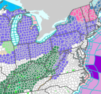
Looks to be filling in nicely. Id say another inch is doable based on that..gif.ebfd874fb5b0bb50cb6b2fbd97fb890e.gif)
-
Pittsburgh/Western PA Winter 2024-2025 Thread
RitualOfTheTrout replied to Rd9108's topic in Upstate New York/Pennsylvania
Radar indicated change over should be going through Allegheny now. Actually a couple wet flakes mixing here too now. -
Pittsburgh/Western PA Winter 2024-2025 Thread
RitualOfTheTrout replied to Rd9108's topic in Upstate New York/Pennsylvania
I agree, only to add that has been a problem to some extent (fast Pac flow) for more than just this season. -
Pittsburgh/Western PA Winter 2024-2025 Thread
RitualOfTheTrout replied to Rd9108's topic in Upstate New York/Pennsylvania
Right now its really the only model showing it, but its an easier path (All Southern Stream) to something vs what we needed with the big phase. If it can amplify nothing to really suppress it. -
Pittsburgh/Western PA Winter 2024-2025 Thread
RitualOfTheTrout replied to Rd9108's topic in Upstate New York/Pennsylvania
Anytime you are depending on the PV let alone interactions with individual lobes rotating around its absolutely tenuous. To be honest aside from maybe a run of the cmc this was never going to be a huge storm for us anyways. -
Pittsburgh/Western PA Winter 2024-2025 Thread
RitualOfTheTrout replied to Rd9108's topic in Upstate New York/Pennsylvania
Yep, CMC and Euro both a step back from what we need, sloppy phase. Euro compensates a little with a little stronger southern shortwave. Really need that clean early phase. Could still move back to that idea. -
Pittsburgh/Western PA Winter 2024-2025 Thread
RitualOfTheTrout replied to Rd9108's topic in Upstate New York/Pennsylvania
Probably a good sign for the Euro then. Should be rolling in shortly. -
Pittsburgh/Western PA Winter 2024-2025 Thread
RitualOfTheTrout replied to Rd9108's topic in Upstate New York/Pennsylvania
Impromptu sled trip to my parents in southern armstrong. Still ripping snow here 3+, not sure about back home. Great morning! -
Pittsburgh/Western PA Winter 2024-2025 Thread
RitualOfTheTrout replied to Rd9108's topic in Upstate New York/Pennsylvania
Moderate here again too. Big flakes exploding on contact lol. Some rimming on the flake structure is noted now so mixing is probably about to start. -
Pittsburgh/Western PA Winter 2024-2025 Thread
RitualOfTheTrout replied to Rd9108's topic in Upstate New York/Pennsylvania
Looks like 00z Euro and CMC did what jwilison was saying is needed with the faster / cleaner phase. Id take either of those. Im not sure how much better that could get, but like I said yesterday that interaction isn't going to be resolved well yet, and a relatively minor change will have a big effect on us since we need the perfect phase timing to pull it west. -
Pittsburgh/Western PA Winter 2024-2025 Thread
RitualOfTheTrout replied to Rd9108's topic in Upstate New York/Pennsylvania
Nope, just enjoying. Can post about it once the deluge starts. Looks like at least an inch. -
Pittsburgh/Western PA Winter 2024-2025 Thread
RitualOfTheTrout replied to Rd9108's topic in Upstate New York/Pennsylvania
Sometimes you just gotta laugh...