
allgame830
-
Posts
2,411 -
Joined
-
Last visited
Content Type
Profiles
Blogs
Forums
American Weather
Media Demo
Store
Gallery
Everything posted by allgame830
-

2/13 Significant/Major Winter Storm Discussion & Observations
allgame830 replied to Northof78's topic in New York City Metro
Ok chief! -
2/13 Significant/Major Winter Storm Discussion & Observations
allgame830 replied to Northof78's topic in New York City Metro
Yeah like my wife up… Northern Westchester -
2/13 Significant/Major Winter Storm Discussion & Observations
allgame830 replied to Northof78's topic in New York City Metro
Omg so many annoying people on here…. I live well outside the city so don’t care… but you all forget the late season snow where it actually accumulated mind you this is in Feb!!!!! Jfc -
2/13 Significant/Major Winter Storm Discussion & Observations
allgame830 replied to Northof78's topic in New York City Metro
Yes but for the city they have some room now for those shifts. I think north 287 is a guaranteed 6-12 range… 4-8 for city -
Agreed. Also the EPS mean was better
-
2/13 Significant/Major Winter Storm Discussion & Observations
allgame830 replied to Northof78's topic in New York City Metro
Gotcha! Thanks for clarifying that. also @MJO812 the EPS mean is definitely better the op. -
2/13 Significant/Major Winter Storm Discussion & Observations
allgame830 replied to Northof78's topic in New York City Metro
So then what exactly are you implying? You saying the 6z euro is crazy? -
Usually see a gradual push back north in last 24 hours anyway…. Euro only model doing this so I don’t think it should be that much of a concern
-
2/13 Significant/Major Winter Storm Discussion & Observations
allgame830 replied to Northof78's topic in New York City Metro
Me neither. At this point we can afford that late last minute push north. -
2/13 Significant/Major Winter Storm Discussion & Observations
allgame830 replied to Northof78's topic in New York City Metro
Relax @MJO812 lol…. Only model what that depiction! -
2/13 Significant/Major Winter Storm Discussion & Observations
allgame830 replied to Northof78's topic in New York City Metro
Better have this trend happening 24-36 hours out -
2/13 Significant/Major Winter Storm Discussion & Observations
allgame830 replied to Northof78's topic in New York City Metro
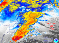
Winter Storm Warning URGENT - WINTER WEATHER MESSAGE National Weather Service New York NY 327 PM EST Sun Feb 11 2024 CTZ005>008-NJZ002-103-NYZ069-070-121000- /O.UPG.KOKX.WS.A.0002.240213T0600Z-240213T2300Z/ /O.NEW.KOKX.WS.W.0002.240213T0600Z-240213T2300Z/ Northern Fairfield-Northern New Haven-Northern Middlesex- Northern New London-Western Passaic-Western Bergen-Rockland- Northern Westchester- 327 PM EST Sun Feb 11 2024 ...WINTER STORM WARNING IN EFFECT FROM 1 AM TO 6 PM EST TUESDAY... * WHAT...Heavy snow expected. Total snow accumulations of 5 to 10 inches. * WHERE...Parts of northeast New Jersey and southeast New York, and all of interior southern Connecticut. * WHEN...From 1 AM to 6 PM EST Tuesday. * IMPACTS...Travel could be very difficult. The hazardous conditions could impact the Tuesday morning commute. PRECAUTIONARY/PREPAREDNESS ACTIONS... If you must travel, keep an extra flashlight, food, and water in your vehicle in case of an emergency. Check local Department of Transportation information services for the latest road conditions. && $$ For more information from the National Weather Service visit https://weather.gov/nyc -
2/13 Significant/Major Winter Storm Discussion & Observations
allgame830 replied to Northof78's topic in New York City Metro
Yup which is all in the Upton forecasting area… also which is part of the thread discussion. -
2/13 Significant/Major Winter Storm Discussion & Observations
allgame830 replied to Northof78's topic in New York City Metro
lol yeah. But hell is always city/coast blah blah all the time. I get it the city/coast has had really bad luck but still….. -
2/13 Significant/Major Winter Storm Discussion & Observations
allgame830 replied to Northof78's topic in New York City Metro
So what’s wrong with this 25-30 miles north of battery park please tell me. We are still in the subforum! -
2/13 Significant/Major Winter Storm Discussion & Observations
allgame830 replied to Northof78's topic in New York City Metro
Might be unreasonable for city and coast but not for areas 25miles north….. why do a lot of you people forget the NW crew….. @CPcantmeasuresnow said it yesterday…..UGhhh @cleetussnowlol -
2/13 Significant/Major Winter Storm Discussion & Observations
allgame830 replied to Northof78's topic in New York City Metro
Your right people forget about the areas NW of the city. -
2/13 Significant/Major Winter Storm Discussion & Observations
allgame830 replied to Northof78's topic in New York City Metro
Winter Storm Watch URGENT - WINTER WEATHER MESSAGE National Weather Service New York NY 317 PM EST Sat Feb 10 2024 CTZ005>008-NJZ002-103-NYZ067>070-111000- /O.NEW.KOKX.WS.A.0002.240213T0600Z-240213T2300Z/ Northern Fairfield-Northern New Haven-Northern Middlesex- Northern New London-Western Passaic-Western Bergen-Orange-Putnam- Rockland-Northern Westchester- 317 PM EST Sat Feb 10 2024 ...WINTER STORM WATCH IN EFFECT FROM LATE MONDAY NIGHT THROUGH TUESDAY AFTERNOON... * WHAT...Heavy snow possible. Total snow accumulations of 6 to 8 inches with higher amounts around 10 inches possible across the higher elevations. * WHERE...Portions of southern Connecticut, northeast New Jersey and southeast New York. * WHEN...From late Monday night through Tuesday afternoon. * IMPACTS...Travel could be very difficult. The hazardous conditions could impact the Tuesday morning commute. PRECAUTIONARY/PREPAREDNESS ACTIONS... Monitor the latest forecasts for updates on this situation. && $$ For more information from the National Weather Service visit https://weather.gov/nyc -
2/13 Significant/Major Winter Storm Discussion & Observations
allgame830 replied to Northof78's topic in New York City Metro
Right……. I said it yesterday and I’ll say it again…… I guessing it’s never snowed and stuck to the ground with days leading up in the 50’s. Sometimes I just roll my eyes at some of you thats why I barely post! -
2/13 Significant/Major Winter Storm Discussion & Observations
allgame830 replied to Northof78's topic in New York City Metro
Right it’s never accumulated in the past with 50/60’s in the days leading up to a storm…. -
26/21… RH 80% hmmmm lol
-
Now it’s legit light snow.
-
Yeah I agree I wasn’t expecting anything prior to 11am… maybe just maybe a positive bust! RH is at 70% which isn’t too bad. 27/20 update: 26/20… 76% RH
-
Now more consistent flurries starting to fall. 27/20 with 70% RH.
-
Had some random flakes here in Thornwood NY a little while ago


