

mob1
-
Posts
2,346 -
Joined
-
Last visited
Content Type
Profiles
Blogs
Forums
American Weather
Media Demo
Store
Gallery
Everything posted by mob1
-
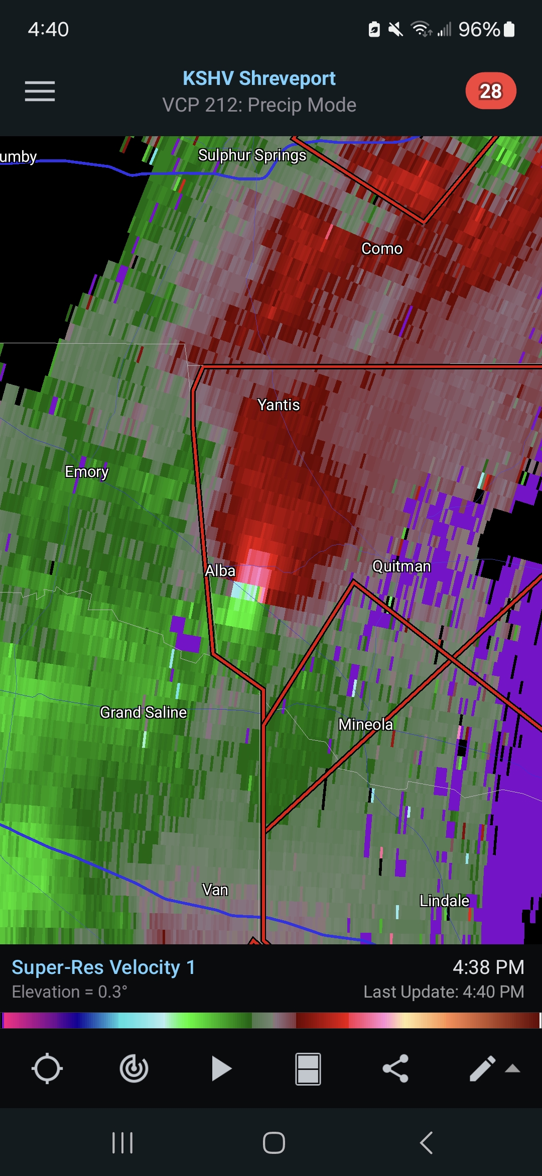
That cell is now PDS warned and has a fairly significant TDS. Surprisingly busy day in TX, we'll see what happens as they move east into better instability.
-
That is a pretty mean looking couplet entering the Holly Lake Ranch area.
-
PDS warning with that one. Edit; it occluded just north of Clarksville but looks like it's about to put down another one. On a related note, tornado parameters in Arkansas are insane right now.
-
It's in a crappy radar spot, but odds are pretty good that the tornado north of Grand Saline is a formidable one.

-
It has occluded now for the most part as it heads to Midway AL, but that was an extremely intense couplet for a while as it went between Troy and Banks. It's fortunate that it wasn't a few miles west.
-
That debris signature near Troy is NASTY.
-
That cell near Troy looks nasty, PDS warned now.
-
New line of convection going on in eastern KS, environment ahead of it seems to be recovering decently from the morning precipitation.
-
Euro is pretty much mood flakes. Horrible trend.
-
Discussion-OBS snow event sometime between 06z Thu 2/20-12z Fri 2/21?
mob1 replied to wdrag's topic in New York City Metro
It's more than merely close, look at the trajectory in the final few frames. It's the NAM so take it with a grain of salt, but verbatim it's great. -
Discussion-OBS snow event sometime between 06z Thu 2/20-12z Fri 2/21?
mob1 replied to wdrag's topic in New York City Metro
Not as bad as I thought, but definitely a step back from 06Z. -
Discussion-OBS snow event sometime between 06z Thu 2/20-12z Fri 2/21?
mob1 replied to wdrag's topic in New York City Metro
Euro is awful as well. -
Discussion-OBS snow event sometime between 06z Thu 2/20-12z Fri 2/21?
mob1 replied to wdrag's topic in New York City Metro
This is so over
-
This is no good
-
They're one small negative trend away from getting next to nothing (in fact, they already get that on the CMC).
-
Canadian is a complete shutout
-
Discussion-OBS snow event sometime between 06z Thu 2/20-12z Fri 2/21?
mob1 replied to wdrag's topic in New York City Metro
GFS is horrific -
Discussion-OBS snow event sometime between 06z Thu 2/20-12z Fri 2/21?
mob1 replied to wdrag's topic in New York City Metro
.thumb.png.d63a455b24a119dca0d28be9654bd8bb.png)
-
Discussion-OBS snow event sometime between 06z Thu 2/20-12z Fri 2/21?
mob1 replied to wdrag's topic in New York City Metro
How so? This is nearly identical to the storm earlier this year (don't remember the date) that did the exact same thing. This isn't one of those years that storms come back from the dead. -
Discussion-OBS snow event sometime between 06z Thu 2/20-12z Fri 2/21?
mob1 replied to wdrag's topic in New York City Metro
If I had to pick something positive from this run, it's that the storm is already so strong at that latitude. The 2015 storm that phased too late for us (and buried LI and New England) scarred me for life. -
Discussion-OBS snow event sometime between 06z Thu 2/20-12z Fri 2/21?
mob1 replied to wdrag's topic in New York City Metro
There was a storm earlier this year that had an almost identical progression to this (I'm almost sure it's @Stormlover74's avatar). Models showed an absolute bomb for a few cycles despite a tainted ridge, and eventually it showed the ridge rolling over and the storm stayed wayyyyyy out to sea. -
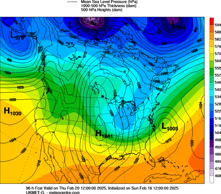
For the UKIE to show 981 mb low with this resolution is a really good sign, these maps usually depict the MLP way too high.
-
Discussion-OBS snow event sometime between 06z Thu 2/20-12z Fri 2/21?
mob1 replied to wdrag's topic in New York City Metro
I think in general at this range the Euro tends to be far more amplified with most storms than the GFS. In terms of it being a well-known bias, I think maybe only recently as the Euro used to have incredible verification scores back in the day in the mid range. They tinkered with it a little and now it definitely is a bit more overzealous in the 4-7 day range, whereas the GFS is the opposite extreme. Doesn't mean either one is right/wrong this time, but I don't think the notion should be completely discounted. -
Discussion-OBS snow event sometime between 06z Thu 2/20-12z Fri 2/21?
mob1 replied to wdrag's topic in New York City Metro
The January 26-27 2015 bust is a good example of that, the Euro showed an extremely tucked solution and like 40 inches of snow and the GFS was far more progressive (and right). -
Educations come and go, but virtual modeled snow is forever.


.png.ccd33b60334d3ce12b290fc5d2f7f083.png)
