

Blizzard-on-GFS
-
Posts
700 -
Joined
-
Last visited
About Blizzard-on-GFS

-
Snowfall NYC subforum Jan 6 and OBS if needed
Blizzard-on-GFS replied to wdrag's topic in New York City Metro
Hey that's 2" for my house in CNJ, I TAKE. LOL. not gonna happen.... -
E PA/NJ/DE Fall 2024 Obs/Discussion
Blizzard-on-GFS replied to Rtd208's topic in Philadelphia Region
so cool! thanks for the heads up! Also, that Timelapse I stunning. I've always wanted to see the northern lights my whole life so hopefully tonight is the night! -
E PA/NJ/DE Fall 2024 Obs/Discussion
Blizzard-on-GFS replied to Rtd208's topic in Philadelphia Region
Thanks for the awesome explanation! Based on this chart, can you give a rough prediction for the next time window we might see the lights again in our area? I missed the first round! -
After it totally botched the forecast on the last storm for Central New Jersey I’ve lost a lot of trust in it…
-
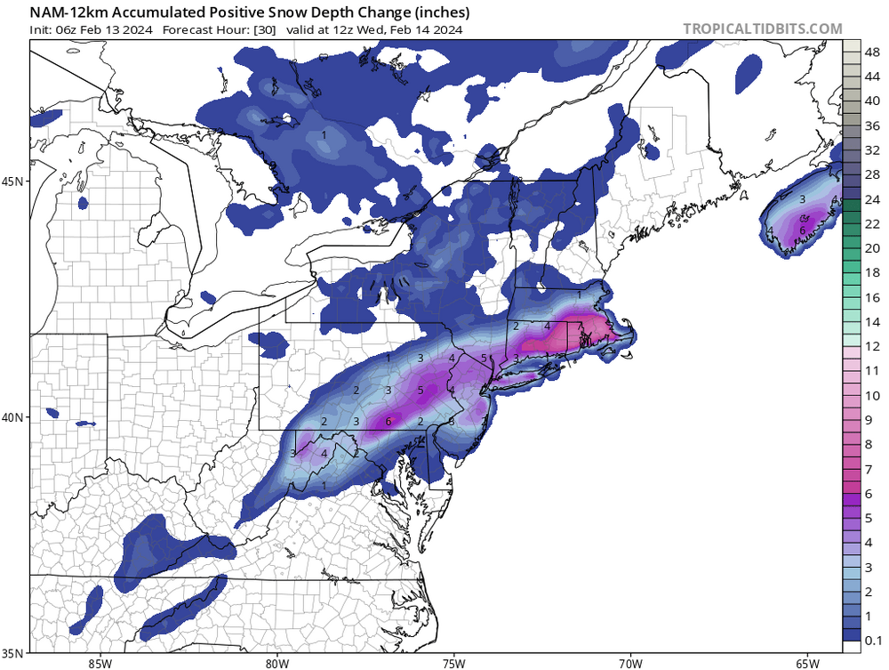
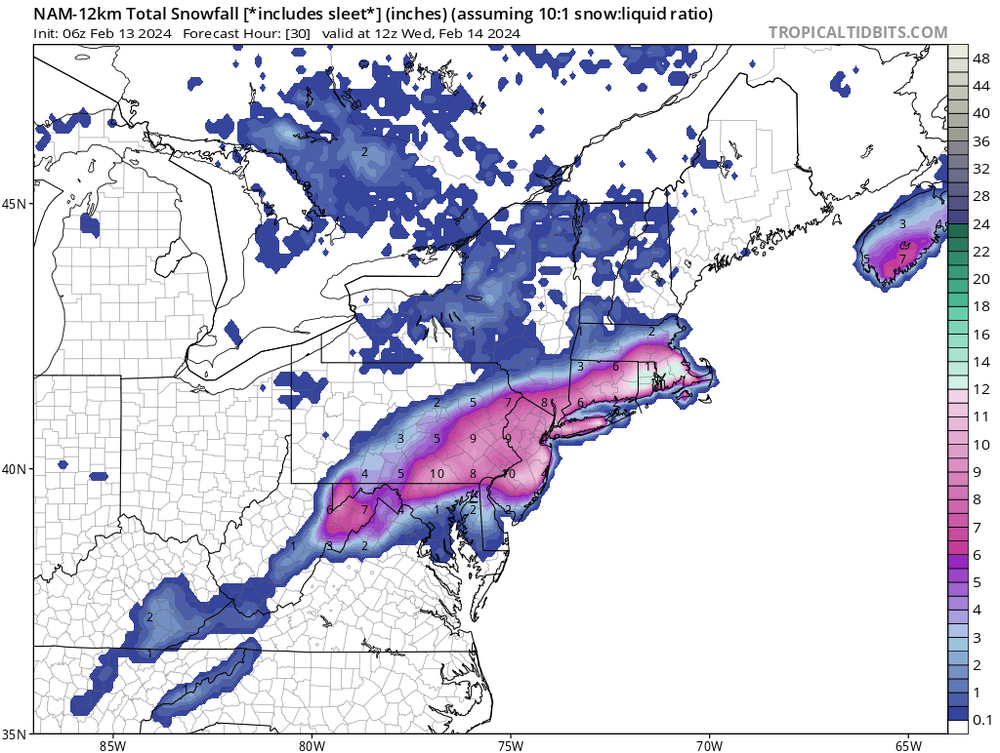
check out the massive differences below. 10” for CNJ on 10-1 vs 2” on snow depth. That should always be a tell tale sign.
-
One thing I’ve learned from this is if temperatures are iffy, always use the snow depth snow maps, or look at soundings. Kuchera and 10-1 maps were completely off, even the 12z Kuchera this morning were printing out over 8 inches of snow for central New Jersey when most places in that area ended up with 1-2” at best. I remember last night the RGEM snow depth had about 1 to 3 inches for the area so it was pretty dang close and it was also pretty good for north and west areas where it had 6 to 8 inches modeled.
-
Epic Bust here in CNJ happy for the NW crew though. We got less than 2" and it has all been completely melted by mid-afternoon here in Bordentown, NJ. Kind of amazing how every model this morning had 4-8" for the area. Probably got around 1.5" if that....
-
That 1-3” zone is going to bust terribly. Should be at least 4-8”
-
i-95 CRUSHJOB!
-
Starting to buy into the idea of an area-wide 5-10". With real heavy rates.
-
BARK BARK!
-
Yes, slightly but the whole idea that this is going to be nothing but rain for odd 95 is definitely a doomer attitude. This is legitimate threat for I 95.
-
Well, well well, the “it’s going to trend north Crew” is in shambles right now lol.
-
January 19, 2024 Powder Snow Event
Blizzard-on-GFS replied to Ralph Wiggum's topic in Philadelphia Region
Ripping snow down in Manahawkin, radar looks great down here, we only saw a little over an inch with the earlier bands. This is our chance here for accumulations. SE Jersey coast looks to be in good shape. Waiting/hoping that this band pivots into an inverted trough as the low pulls away. Gonna be real interesting to see if that feature ends up setting up or not. -
Waiting from them to drop a TOR warning on that bucks county cell. Rotation keeps strengthening


