

Voyager
-
Posts
11,416 -
Joined
Content Type
Profiles
Blogs
Forums
American Weather
Media Demo
Store
Gallery
Posts posted by Voyager
-
-
1 minute ago, Atomixwx said:
Yes. Gold. Coincidentally, Gold is what you need to not go bankrupt on the turnpike.
Gold is also what you need on the NWS probabilistic snow maps as well...if you want to see significant snow anyway.
-
 1
1
-
-
22 minutes ago, Atomixwx said:
CTP keeps dropping the hammer further south but keeps a razor-sharp gradient right at the Flathead's house on the toll road.
They seem to be realigning the gradient to a more southwest to northeast trajectory. Last night it was a bit more west to east, and I was in the 8-12 zone. Per their latest map, I'm now in the 6-8 zone, so while some of your totals are increasing, mine are decreasing.
-
Just now, pasnownut said:
yes, but it is inside its "wheelhouse", so it should be gaining some weight in forecasts.
not saying we win, but we may just lose better....

-
11 minutes ago, bubbler86 said:
Hopefully the 6Z Euro is not the trend. Going to need the Euro to bust on this one.
I've yet to figure out where to get and see the 6z/18z Euro output. What sites have it?
-
3 minutes ago, Ralph Wiggum said:
I was never big on overpaying for one player. It's not like he is going to make us an overnight contender by himself anyway. Why waste the cash? Put a chunk of that money towards a legit ace starting pitcher instead. Need a solid top 3 which we dont have still.
Can't say I disagree, but they are going hard after Machado or Harper, so I'd rather have Harper. I think he has more of a team attitude than a me attitude like Machado. As for starting pitchers, who's still available. Keuchel?
So as not to go off topic too much, this storm. As is usual around these parts, track and precip types are giving me a headache. One takeaway, it seems, is that even up my way, the best rates are going to be wasted on zr or ip. My NWS point-click has 1-2 inches of "precipitation" during the darkness hours Saturday night/Sunday morning. I'll admit to not digging too deep into the models for other than surface temps and precipitation totals, since I was in the truck, and navigating Tidbits or Pivotal is quite cumbersome on a cell phone. I've mainly been following you guys and the Central PA forum for good information.
-
I don't pay attention to The Weather Channel, and I really hate the naming of winter storms, so I just now found out that this weekend's storm is named Harper. With that thought in mind, let's go Phillies. Sign Bryce and get it over with...lol
-
12 minutes ago, Itstrainingtime said:
Did they change the wording in your Winter Storm Watch? I know last evening for your area it was 6" or more.
Nope. As of this morning, still the same. I see they upgraded to warnings up along the northern tier, though.
-
Still snowing lightly, but I didn't get near what some of you got. I put the dog out, and would say there's only about a quarter inch out there.
As for the NWS forecast...man, if this was all snow. They won't give me frozen accumulations in the point-click, but for Saturday night, they say 1-2 inches of "precipitation". Too bad most of that in that time frame will be taint.
-
16 minutes ago, Blizzard of 93 said:
Speaking of tonight’s snow, light snow has picked back up here in Marysville. We are now over 1 inch so far tonight.
7 minutes ago, CarlislePaWx said:Me too. Snowing nicely again and just hitting the 1.0" mark. Looks like you can subtract 2" from the weekend storm total map.
And very little of that got here. What we got so far wasn't enough to even dust bare ground or streets/sidewalks.
-
11 minutes ago, Jim Marusak said:
i've seen the reality of this before, and the models may now be picking this up in the highest resolutions. when you're talking elevations in northeast PA, you have the cities at the valley floor of the Susquehanna at ~ 450ft MSL (~145m), which translates to ~14hPa from Sea Level Pressure using normal assumptions. but when we talk most of the towns in the Poconos, we're talking most crevices at ~1300-1400ft msl (400-430m) which translates to ~40-43hPa, with the mountain tops between 1900-2300ft msl (580-700m), which can be ~58-70hPa. if you look at most sounding profiles carefully in an over-running situation like we are looking at and then look at the real temperatures, you'll actually be warmer say in Hazleton or Mount Pocono than you would at Avoca or Wilkes Barre because the warm layer aloft in that small distance doesn't change height much, but the column in which the air can cool back down is a lot shallower at ~925 or 935 hPa in Hazleton or Tobyhanna than it would be going all the way down to ~980-990 hPa in downtown Wilkes Barre, Pittston, or Mocanaqua. As a result, you'll more likely see sleet in the valley near US 11 but head up the mountain on PA 93, I-81, PA 115, PA 309, or I-380; and you're more likely to see it be freezing rain in say Hazleton, Mount Pocono, Bear Creek near the Turnpike, or Tobyhanna because the melted water is cool enough to be super-cooled but not enough to turn all the way to sleet/ice pellets (just a few J short).
So the models, when displaying snow/sleet accumulations, might be picking up on that fact and adjusting amounts accordingly.
Thanks Jim. I was wondering if the elevations we're high enough for such a situation. I know that at times the cold air drains into the valleys such that Hazleton can be as much as 10-15 degrees warmer than where I live in Tamaqua.
-
Just now, CarlislePaWx said:
This is secret. I'm not supposed to tell. But the model was created by Dave Tolleris.
Wouldn't it be called Big Dog or Aleet instead, then???

-
 1
1
-
-
6 minutes ago, anotherman said:
Deep Thunder!!!!!

What's with the "hole" over the Poconos? I've seen that a few times on various models this week.
-
9 minutes ago, Atomixwx said:
Reyno is probably that guy who has a sore throat but still smokes lol. He's pretty crazy, but also really, really smart.
Bernie is really good at what he does, and I like hearing his thoughts on a potential storm.
-
Pivotal Weather has a Kuchera map too that is pretty easy to read.

-
5 minutes ago, 2001kx said:
JACKPOT!!!
Look at that nudge north with the gradient over Schuylkill County. WTF is up with that???
-
I listed to the NOAA weather radio in the truck coming up 83 tonight. The extended forecast was quite wintry for the LSV. Snow and mixed precip with temps only as high as the low 30's during the storm.
In their hazardous outlook, they said watches would likely be hoisted within the next 48 hours.
-
35 minutes ago, kdskidoo said:
I guess my bar is set higher than most in here when it comes to ranking snowstorms. I would classify them as follows:
less than 3" minor/nuisance
3-6"" moderate
6 -12" significant
12-20" major
20-30" crippling
30-40" historic
anything above 40" biblical
This is EXACTLY how I would grade storms. I've never seen a 30+ inch storm (in my backyard anyway) so that would be historic. The over 40 biblical designation is spot on, too, as even in the biggest of storms, our region just doesn't (save one or two locations) ever really hit that number.
As for me, 26 inches is the most I've seen from one storm.
-
1
-
-
14 minutes ago, CarlislePaWx said:
I'm pretty sure he meant that tongue-and-cheek to tease Voyager.
I literally laughed out loud in the truck. Thanks guys!
-
8 minutes ago, CarlislePaWx said:
I know bubbler just posted the map with the polar vortex paying us a visit...but really, you guys should go do a loop of either the gfs or gfsv3 18Z runs for 2M temps. They are insanely cold...particularly days 10 through 15. Daytime highs at MDT below +10 and nights below zero...well below until it reaches 13 below at the end of the run. This type of cold will exceed Jan 2015 cold IMO. Of course, throw in a few snowstorms to deepen the snowpack and you've got the recipe for 1994.
Must. Get. To. Phoenix.
lol... I doubt I can, but I sure do wish I could escape this.
-
Nothing here yet. Not that I was expecting, nor hoping for any.
-
Sunny and 34 here. Hope it stays this way here, and all of you down there cash in nicely! I can't think of a better storm scenario for me...
-
14 hours ago, RedSky said:
18z GFS gives us 24 hours of snow, it looked good until the qpf was 1-2" snow. Can it snow that lightly I doubt it?
Yes it can. We've had 24 hours of "pixie dust" up here in Tamaqua that, when all was said and done, was about 1-2 inches. The snow that day was equivelent to a light drizzle, both in intensity and visual impairment.
-
28 minutes ago, daxx said:
Does that mean when you leave it will get warm again? If so please stay!!
lol...
The cold seems to follow me around the country, so who knows. Last spring it was the same way. every time I went west a cold storm would come in off the Pacific within a day of my arrival.
-
18 minutes ago, MAG5035 said:
It sure did back this way. A light glaze of freezing rain and sleet is likely the culprit for multiple crashes/road closures this morning up in Cambria County. One on US 219 (between Johnstown and Ebensburg) and the other on US 22 (Between Altoona and Ebensburg)
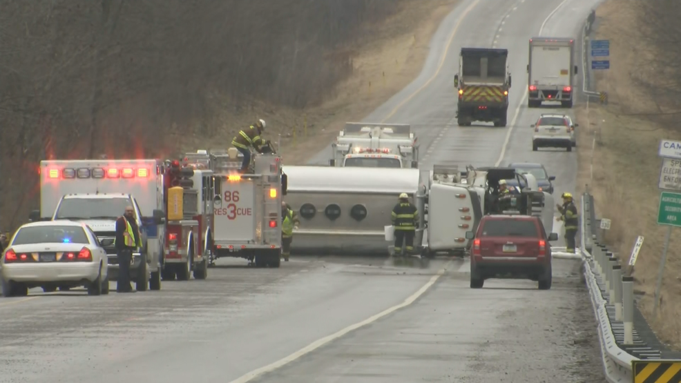
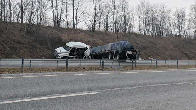
Yikes. That's why winter and me don't get along so well ..

Central PA - Winter 2018-19
in Upstate New York/Pennsylvania
Posted
Shovel it as it flips and keep salting the hell out of it...
Honestly, I don't know. That's always been my dilemma in these types of storms. When to shovel for maximum (and safe) effect and the least amount of work.