

Syrmax
-
Posts
5,654 -
Joined
-
Last visited
Content Type
Profiles
Blogs
Forums
American Weather
Media Demo
Store
Gallery
Posts posted by Syrmax
-
-
NAM did well identifying the band of post frontal snow over CNY. Looks like a pasty inch of snow covering most everything as KBUF also described last evening in their AFD.
-
I was downtown today for work Christmas lunch, was 65 on my car thermometer.
We're down to 52 now. Not bad but trend is down, like the stock market...party's over!

-
13 minutes ago, wolfie09 said:
Some lake effect potential on a NW flow, especially south of Oswego county, maybe max can get in on some..
hi rez Canadian

Hopefully! Hard to think that a White Xmas is possible after today's beautiful weather but looks like we should scrape out a few inches one way or another, thru Sunday.
-
 1
1
-
-
2 minutes ago, wolfie09 said:
Yup
Everyone always wants the cold, now enjoy it HAHA (not necessarily you lol)
Avg high in winter is in the upper 20's , avg to slighty above avg is fine by me..
Why some want negative anomalies in upstate ny during winter, i have no clue lol
Pretty much agree. Maybe it's a sign of getting older. Its plenty cold enough here during all but the 1 in 10 year anomalously mild winters that occur. Even then we scrape out 40-50" of snow...which is a normal value for most people in many areas.
-
1
-
-
48 minutes ago, wolfie09 said:
It's a little comical, if you look at the top image u can see it go from 99% to 60% right over pulaski lol
I'm starting to think they are the rip off zone of oswego county lol Especially when it comes to p-type..
The funny thing is the majority of folks in fulton think it snows way more in pulaski, not sure that is the case..
Noone lives in Pulaski. How would we know?
")
-
 1
1
-
-
7 hours ago, wolfie09 said:
i think We will find away to see a white christmas..
.gif.a95cdb1008678625f12cdfcb3945678b.gif)
I think so too, even though we are in what is becoming our traditional mid December till New Years mild period. The Lakes will provide!
Won't be deep snowcover but most of us won't be totally green by Xmas day.
-
2
-
-
6 hours ago, CNY-LES FREAK said:
Yeah those 4, plus the 7200 students at OSU bonehead, lol! When you speak of the Tug, in such ways then its understandable, but NOT Oswego County.
Sent from my SM-G930V using Tapatalk
Really?
-
6 hours ago, wolfie09 said:
The best events are the ones that pop up out of nowhere..
Agree. As unremarkable as the SR and LR looks, we've seen this before...something usually develops. We may not like the outcome always but it's not like we live in the high desert of Nevada.
-
SN- around SYR. Fluffy dendrites. Maybe a 1/2" of low density fluff so far. We may get to 130" avg at 1" per day at this rate....
-
18 minutes ago, wolfie09 said:
Christmas day miracle?
Actually its the day after but timing is never good this far out..
GFS usually Does a good job at showing time periods of interest..
Few of the latest GFS OP runs..
Some work to do on those model runs...to avoid a Christmas Day gully washer. Fortunately, there's time.
-
Nice band off GB up in Ontario. About 1" here this eve. An inch a day keeps Spring away...
-
19 minutes ago, CNY_WX said:
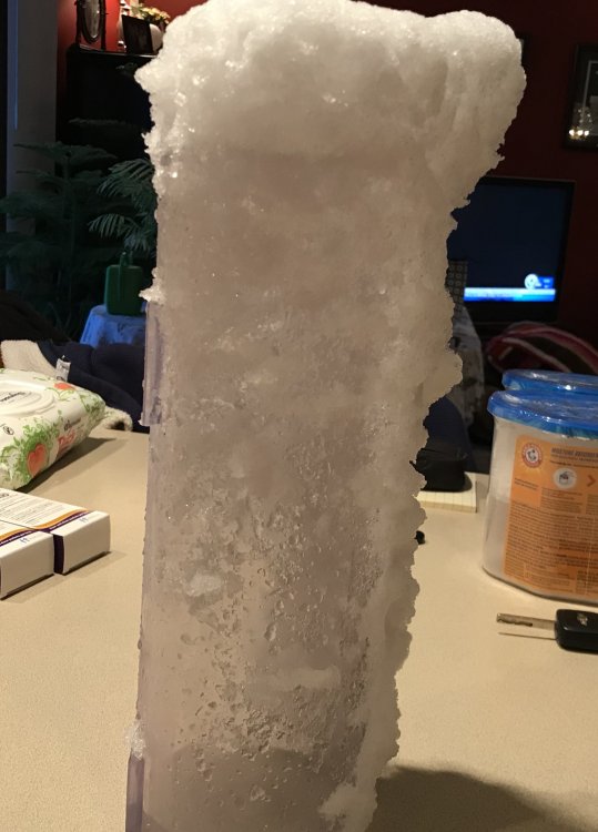
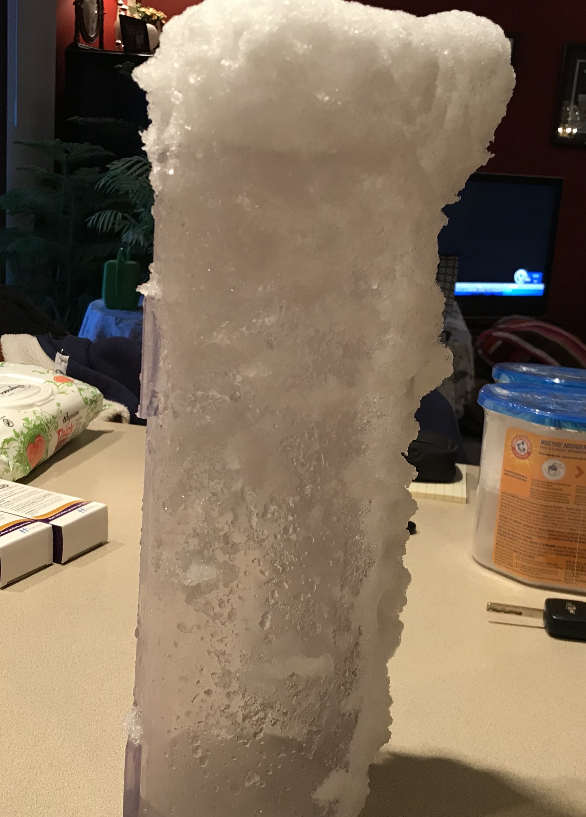
I just measured 4.6 inches. I don’t know how accurate my LE will be because the snow just pileup on the opening to the cylinder. I’m going to let the snow melt as is and what goes in the tube will be counted and what falls outside won’t.
Same problem here. If I wasn't lazy or needed to snowblow driveway, I'd do a core sample. I had 5.3" snow and 0.71" liquid.
-
Looks like around 2" here, maybe 3" by eye balling it.
-
1
-
-
We'll see what the moisture coming down from the north does but I'm at maybe 1". Looks like low end of 3-6" might verify here.
-
12 minutes ago, CNY-WXFREAK said:
Nah, we're good but I wouldn't want to be within 10 miles of the lake cause they are going to be affected by the warmer waters off the Lake. KBGM went with warnings which surprised me so now I feel a bit more confident

I hear ya and agree. KBGM usually more stingy but...those warnings address counties with elevation...they dont split CWAs other than Oneida. So I think 4-6" here is probably good.
-
Its unreal how variable the possible outcomes are for most locations with this event, from model to model. Best to keep expectations in check unless you have some elevation going for you. Ugh.
-
Steady snow downtown Cuse the past hour. Not sticking to anything though. Pretty much wasted qpf.
-
Was all snow but very wet from my place down thru Bville into Cuse. With lighter intensity downtown it's hard to tell what's falling. Regardless, even if snow it won't accumulate downtown. Should probably factor that into qpf and clown map expectations for some locales
-
6 hours ago, CNY-WXFREAK said:
Closing in on a 1" of liquid already!

I had 1.36" rain in last 24 hrs.
-
1 minute ago, wolfie09 said:
Definitely some elevation dependency going on..
Although i'm only at 600 feet asl and the models have me on the edge of decent accumulations..
I think elevation will be the key with this one, with marginal temps. It’s still November after all so can’t get despondent about it. 6 or 7” isn’t unreasonable IMBY which would put us close to 30” for the month, with a Nov avg of about 9”. Pretty Boss overall. Now let’s queue up that Joe Bastardi ditty about the “weather in November the winter remembers...”or something like that.
-
1
-
-
31 minutes ago, BuffaloWeather said:
Euro weeklies look toasty in weeks 3 and 4. Thinking short weather for Christmas around these parts. It's warm from Mid December to the first week of January which coincides with the MJO cycle.
That seems to be happening a lot in recent years, as in the past decade plus. Pretty sure it’s just random probability distribution as nothing else makes sense, but it kind of $ucks timing wise. It’s like we get a pre-January thaw, or the January thaw happens in mid/late December. I could be off on this but that’s my perception anyway.
-
That's a nasty cold rain out there presently. When is Spring?
-
1 hour ago, Shea said:
Hello, I thought I should sorta say hi before I started to post randomly. I just moved up to Fort Drum from the far southern Kentucky area so while I know a far amount about severe thunderstorm forecasting and lingo I feel a tad bit lost when reading about snow. But basically I’m just happy to see any appreciable winter weather. After 7 years I’m already in heaven. I’m looking forward to learning.
Welcome. You’ll see more than your fair share of “appreciable” winter weather up near the Drum.
-
Just got back from Chicago area...for my sons graduation from Navy Bootcamp (it’s still the living hell I remember it as being). Thankfully the storm timing wasn’t a week earlier. Would not have been helpful on graduation week. Not that it was warm there (30s) but I managed to miss the record cold here on Thanksgiving. I’ll gladly pass on that.
Having been loosely in touch with weather for the past week or so...I noticed the WSW’s up north of here. I liked the previous unconsolidated Watch/Warning system better as in situations like this, when I’d see a Lake Effect Snow Watch up north, I knew it was something I could largely ignore here nearer to SYR. Just putting up generic WSWs takes a bit more sleuthing to figure out what’s going on (I figure it’s for projected LES on/near the Tug).
-
1
-

Upstate/Eastern New York
in Upstate New York/Pennsylvania
Posted
I have 8.5" in December....the hard way.