

Syrmax
-
Posts
5,654 -
Joined
-
Last visited
Content Type
Profiles
Blogs
Forums
American Weather
Media Demo
Store
Gallery
Posts posted by Syrmax
-
-
52 minutes ago, Thinksnow18 said:
Gets into most of northern Erie County as well. Those in Amherst, Clarence and williamsville tend to get overlooked in this setup.
KBGM decidedly Bearish on lake effect snow potential last I read. Too cold, dry air, small dendrites etc. Probably accurate in that it wont be a big accum after the storm, at least not here.
-
51 minutes ago, wolfie09 said:

Wow.
Snows falling here in Clay, 1.5" today total now. Nice pre party. We just hit50" for season...
-
10 minutes ago, rochesterdave said:
NAM initiated here at 1000. Deeper is better. “That’s what she said”
SN- in Syracuse. Big dendrites. The fun just keeps rolling on...
-
2 minutes ago, phoenixny said:
What's the test model?
FV3 is still in testing. Scheduled to replace GFS later this year. So for now FV3 runs after GFS and can be tweaked before becoming operational, I believe.
-
9 minutes ago, phoenixny said:
Love the FV3 ON HOUR 288.
That's a good look!

-
45 minutes ago, phoenixny said:

Buy you and Ty a beer at Duskies if no county goes to Blizzard Warnings by Sunday morning. Ha! All states included!!!
Are actual BWs issued anymore or has the NWS criteria reduction effort eliminated these?
-
1 minute ago, phoenixny said:
Are we dealing with a lot of dry air to start on this?
I wouldnt think so. It's pretty moist out there...light SN-
-
- From NWS:
- BLZD
-
Blizzard- A blizzard means that the following conditions are expected to prevail for a period of 3 hours or longer:
- Sustained wind or frequent gusts to 35 miles an hour or greater; and
- Considerable falling and/or blowing snow (i.e., reducing visibility frequently to less than ¼ mile)
-
Just now, CNY-WXFREAK said:
It does.
Frequent guests is part of criteria now. Softened up to save KBOX.
")
-
 1
1
-
 2
2
-
-
2 minutes ago, phoenixny said:
Bitched so many times at New England Blizzard Warnings that never verify! We might have our chance during the next three weeks as someone just posted. I still have a kid at PCSD asking me on Tuesday snow day potential!!!
PHX is stingy with snow days. What was it last week there was a pretty nasty day where most schools delayed then packed it in for the day. Not Phoenix....
-
4 minutes ago, phoenixny said:
I hear ya but not gonna right it off completely as there is massive hype, and have seen blizzard warnings before that never verify for Oswego and Otsego County. Last one for me was 93 which verified. Long time. Wish this was down to a 980 in southwest Pa. Gonna be fun none the less.
Biggest issue will be achieving sustained wind speeds. I'll bet we end up close but no cigar, from a strict definition standpoint.
-
Nice link. I actually just read it. I used to understand (mostly) the CSI process but haven't studied it in years. Thanks
-
4 minutes ago, wolfie09 said:
I had to make sure they weren't the same image like three times lol
Look at the lower right on those maps. So brutal. Memories of 1980s and 90s..
-
1
-
-
It gon snow
-
6 minutes ago, tim123 said:
Kuchera?map
Greedy.
-
2 minutes ago, DeltaT13 said:
The further NW the low track the slower and lesser the transfer. Also, stronger systems with better upper level support (like the nearly perfectly coupled upper level jets in this one) allow the primary to maintain strength and prevent a secondary low from developing. That said, you can see this surface low getting real baggy and expanding South, especially as the front crosses the coast. It's trying, thankfully its just not happening on the these NW runs.
Thanks!
-
I'm probably wrong but I'm not seeing a whole lot of "redevelopmen" on these model runs...more of a Miller A system blazing by. I realize that even Miller A's often have center jumps or quasi redevelopments but not seeing that so much. Maybe a met can comment.
-
7 minutes ago, Charlee4615 said:
Finally fv3 finished running. Now I can leave for the gym in peace! See ya round 9
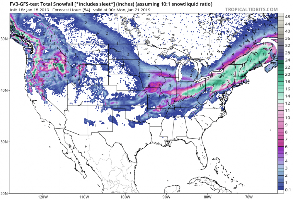
17" at 10:1. That's gonna be very interesting at higher ratios.
-
30 minutes ago, rochesterdave said:
Icon and NAM cutting totals on NW side.
Those are belleweather models too.
-
12” BUF
18” ROC
16” SYR
20” BGM
-
Just now, mattny88 said:
i wish they did..this was used as of their noon air broadcasting
I've noticed this in many different places. Local tv maps tend to focus on their immediate area and dont seem to put much thinking into the areas on their fringes. Take it FWIW.
-
2 minutes ago, mattny88 said:
hate to be the bear of bad news...just saw trusted reliable source wsyr new snowfall map...not looking promising for the western edge..even me in the city of oswego there now calling for 5-10inch range..down from the 10-18 inch snow map they put out early this morning..what gives? what did they see in the latest models to suggest pushing the slug of greater accumulations and shifting the entire map like 30 miles east???? cnylesfreak? or wolfie or anybody know the reason and on board with their thinking? let me know guys
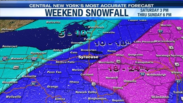
That map has ROC at 5-10"...C'mon now.

-
17 minutes ago, Buffalo Bumble said:
I know we have to get through this event...but what in the world is going on with Euro op run from hour 144-240? I don't know whether to be amazed at what it's showing or afraid...
Haven't looked. Torch?
-
Another thing...due to the partial govt shutdown...NWS Mets are apparently not getting paid. Try to keep that in mind when ripping them this weekend. It's one thing to be a weenie towards paid professionals. But unpaid...gotta cut some slack and maybe thank them for hanging in there.
-
1
-


Upstate/Eastern New York
in Upstate New York/Pennsylvania
Posted
Sorry, but the NE sub has tossed every.single.model. and thermal profile, other than the Tropic Thunder and Ouija Board models. FV3 tossed also by inference.