GoAPPS
-
Posts
133 -
Joined
-
Last visited
Content Type
Profiles
Blogs
Forums
American Weather
Media Demo
Store
Gallery
Everything posted by GoAPPS
-

2022-2023 Fall/Winter Mountains Thread
GoAPPS replied to BlueRidgeFolklore's topic in Southeastern States
This is one of those rare events when continuous snow manages to grace even Asheville. It’s not really accumulating, but it’s still fun to watch. -
Hello! I've really enjoyed this forum over the last several years. I'm traveling to the UK over the next couple weeks, and I was wondering if there's an equivalent online weather community. Anybody know?
-
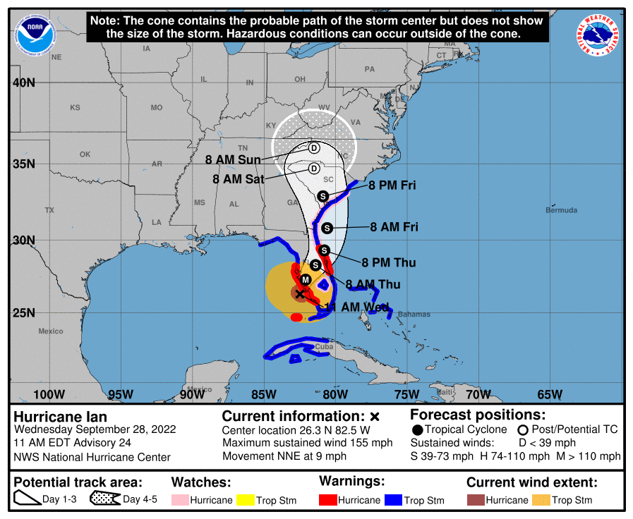
Ian seems to be deviating from the expected N to NW track. It's trajectory looks more WNW at the moment. Looks like it will make landfall near McClellanville, SC, within the hour.
-
There's definitely a westward component to Ian's movement now.
-
That sounds really interesting! Do you mind going into more detail about the synoptic setup of both and how they compare?
-
And tides... next high tide in Cape Coral is just after 6 p.m. -> https://www.usharbors.com/harbor/florida/cape-coral-bridge-fl/tides/
-
Eye is clearing out in the last couple of visible frames. http://www.meteo.psu.edu/fxg1/PSUGOES_MESO1/loop120.html
-
I bet the 2 p.m. advisory will raise some eyebrows.
-
That there's a testament to the folly of man.
-
It’s generally seen as a weenie take to attribute the behavior of an individual storm to climate change. The effects of climate change manifest in aggregate trends over years and decades. The connection with individual storms is weak.
-
https://www.facebook.com/watch/?v=505523217991608 Fascinating behavior from that MCS that came through this morning.
-
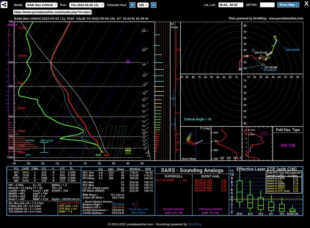
That's quite a sounding for Asheville of all places.
-
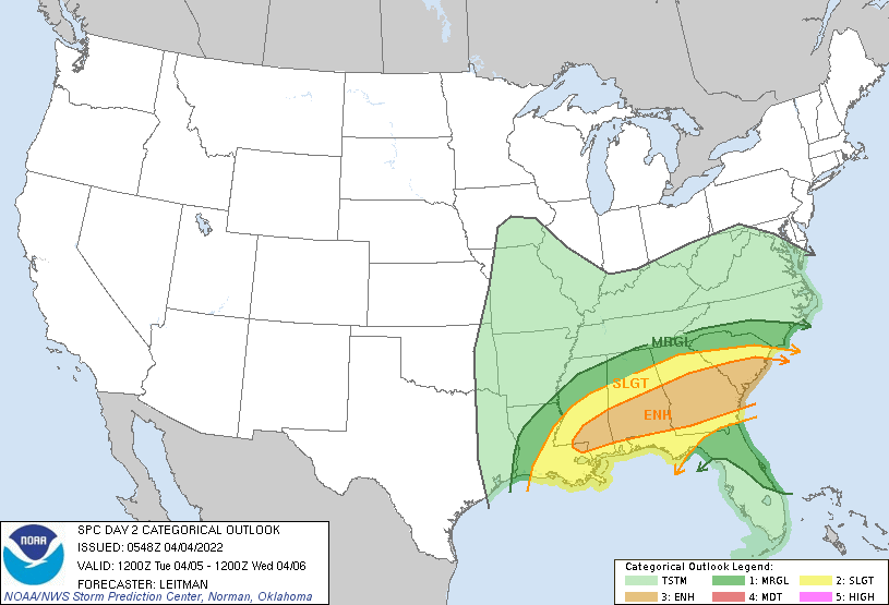
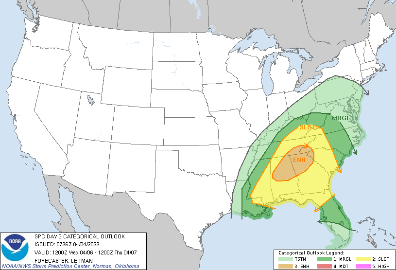
Tuesday and Wednesday are looking more interesting.
-
-
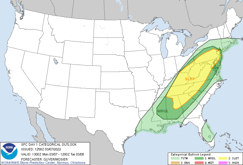
Pretty big expansion of the slight risk area over yesterday.
-
2021-2022 Fall/Winter Mountains Thread
GoAPPS replied to BlueRidgeFolklore's topic in Southeastern States
Pretty decent snow shower in Asheville. -
We're gonna be chasing snownadoes lol.
-
2021-2022 Fall/Winter Mountains Thread
GoAPPS replied to BlueRidgeFolklore's topic in Southeastern States
Is the red sleet/mixed precipitation? -
January 20-22 “bring the mojo” winter storm threat
GoAPPS replied to lilj4425's topic in Southeastern States
FYI, light snow has broken out in parts of the mountains, not depicted on any model. It could bode well for those downstream. -
2021-2022 Fall/Winter Mountains Thread
GoAPPS replied to BlueRidgeFolklore's topic in Southeastern States
The models keep showing a band of light snow blooming around 7 p.m. then moving east. -
2021-2022 Fall/Winter Mountains Thread
GoAPPS replied to BlueRidgeFolklore's topic in Southeastern States
Snow shower in Asheville. -
January 20-22 “bring the mojo” winter storm threat
GoAPPS replied to lilj4425's topic in Southeastern States
18Z Nam's like...
-
2021-2022 Fall/Winter Mountains Thread
GoAPPS replied to BlueRidgeFolklore's topic in Southeastern States
The NAM's treatment of the surface low still looks very odd. Don't CAD setups tend to guide the surface low toward the margins of the CAD? -
2021-2022 Fall/Winter Mountains Thread
GoAPPS replied to BlueRidgeFolklore's topic in Southeastern States
Why is it that warm air can get in here and lower our snow totals but cold air never makes it over the mountains in time? Is it simply that the warm air has an easier time rising over the mountains and funneling in?