Sey-Mour Snow
-
Posts
6,919 -
Joined
-
Last visited
Content Type
Profiles
Blogs
Forums
American Weather
Media Demo
Store
Gallery
Everything posted by Sey-Mour Snow
-
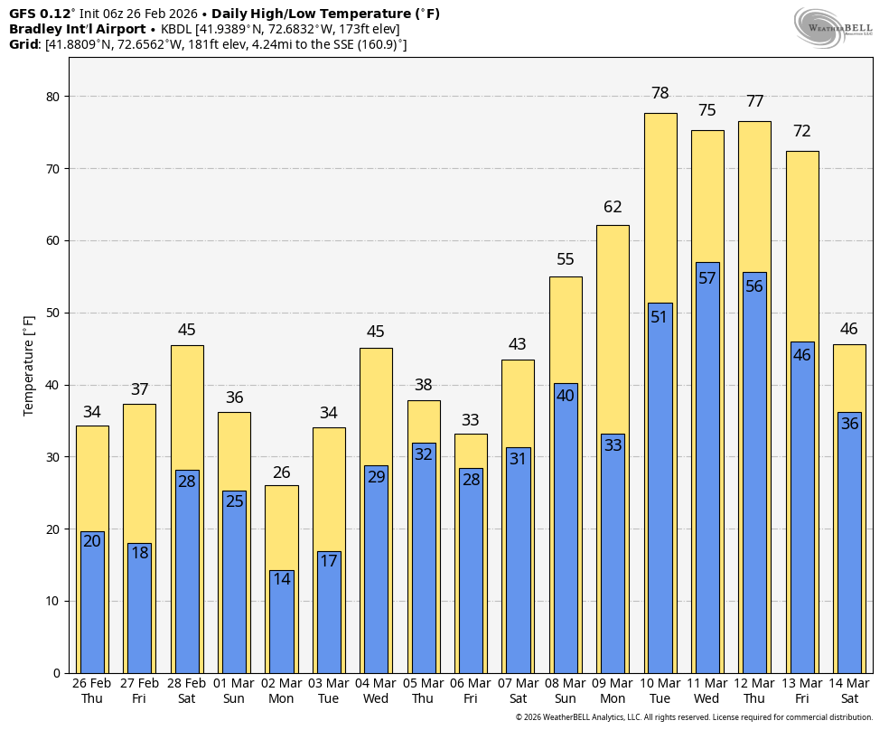
Still 2-3 more snow chances next week but after that holy GFS, the globals have been consistent on torch but 6z gfs was the warmest a 5-7 day torch 70-80 across SN for a few days.

-

Clipper Fires In Wednesday Feb 25 Disco/ Obs
Sey-Mour Snow replied to Damage In Tolland's topic in New England
We don’t do school districts -
Clipper Fires In Wednesday Feb 25 Disco/ Obs
Sey-Mour Snow replied to Damage In Tolland's topic in New England
Exactly ! -
Clipper Fires In Wednesday Feb 25 Disco/ Obs
Sey-Mour Snow replied to Damage In Tolland's topic in New England
That’s BS if they seeked a professional forecast they would have known that snow was forecast to be 5:30-9:30 statewide -
Clipper Fires In Wednesday Feb 25 Disco/ Obs
Sey-Mour Snow replied to Damage In Tolland's topic in New England
63” on the season would be awesome to get to 80”+.. I believe only 1996 and 2013 did that and they both had 30”+ edit maybe 2011 too? Will check the website later -
Clipper Fires In Wednesday Feb 25 Disco/ Obs
Sey-Mour Snow replied to Damage In Tolland's topic in New England
42 and gorgeous out! Roads completely dry like it never snowed. -
Clipper Fires In Wednesday Feb 25 Disco/ Obs
Sey-Mour Snow replied to Damage In Tolland's topic in New England
How much on season -
Clipper Fires In Wednesday Feb 25 Disco/ Obs
Sey-Mour Snow replied to Damage In Tolland's topic in New England
3.3” final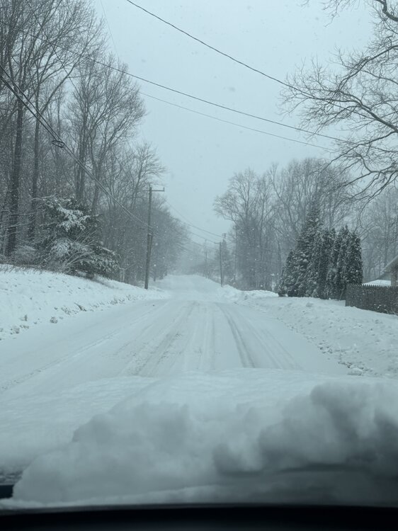
-
Clipper Fires In Wednesday Feb 25 Disco/ Obs
Sey-Mour Snow replied to Damage In Tolland's topic in New England
3 hours btwn steady snow and last flake about 3.5” I’ll get a final measurement soon -
Clipper Fires In Wednesday Feb 25 Disco/ Obs
Sey-Mour Snow replied to Damage In Tolland's topic in New England
2.5” -
Clipper Fires In Wednesday Feb 25 Disco/ Obs
Sey-Mour Snow replied to Damage In Tolland's topic in New England
Will be 2-4” @Damage In Tolland FTW he knew -
Not only have we made Winter Great Again, do we have a new king in the GFS? Time will tell if it owns the EURO again with this, it's been awfully consistent on a good hit Monday.

-
Clipper Fires In Wednesday Feb 25 Disco/ Obs
Sey-Mour Snow replied to Damage In Tolland's topic in New England
Nice daytime snow perfect growth radar is lit for an hour might pull that 3 spot here -
Clipper Fires In Wednesday Feb 25 Disco/ Obs
Sey-Mour Snow replied to Damage In Tolland's topic in New England
Seymour had a delay then closed at 6:30am -
Clipper Fires In Wednesday Feb 25 Disco/ Obs
Sey-Mour Snow replied to Damage In Tolland's topic in New England
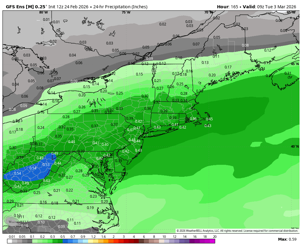
Even 3k slacked off at 00z, the beefier guidance was right looks like we should get .15-20” precip out of this -
Clipper Fires In Wednesday Feb 25 Disco/ Obs
Sey-Mour Snow replied to Damage In Tolland's topic in New England
Hrrr has been horrendous 00z last night had .04” of all of SWCT up to .1” east ct .. look at radar we easily do 2” here with elevation maybe 3”, guidance has hinted on prolonging snow with some enhancement 8-9am along southern ct -
Clipper Fires In Wednesday Feb 25 Disco/ Obs
Sey-Mour Snow replied to Damage In Tolland's topic in New England
Snow quickly borderline heavy all roads covered radar looks solid for 2” animated.mov -
-
The non weenie vista mean for Monday night is 4-6” across SNE, which is still impressive at day 6
-
Only Monday/Tuesday
-
Clipper Fires In Wednesday Feb 25 Disco/ Obs
Sey-Mour Snow replied to Damage In Tolland's topic in New England
NWCT will jack from tomorrow morning, colder and earlier that elsewhere, won't snow hard enough out east with late Feb sun angle -
Clipper Fires In Wednesday Feb 25 Disco/ Obs
Sey-Mour Snow replied to Damage In Tolland's topic in New England
Looks like 5:30 start here, 6:30 start in Tolland -
"Don’t do it" 2026 Blizzard obs, updates and pictures.
Sey-Mour Snow replied to Ginx snewx's topic in New England
AIFS jumped way south (400 miles 00z to 12z) for Thursday night after being so consistent, that model has is losing it's reputation for not being jumpy. Thursday night is on life support now. -
"Don’t do it" 2026 Blizzard obs, updates and pictures.
Sey-Mour Snow replied to Ginx snewx's topic in New England
These weather apps are making us look way worse, it's getting out of control - they shouldn't have accumulations. I'm getting messages about 15-20" of snow next week. Some fake news weather account made a map for 15-20" of snow next week which is freaking everyone out, but on top of that, the Iphone weather app has 18-23" for Seymour Monday night into Tuesday. -
4 snow threats next 10 days lol they are freaking out on our social media about my post for tomorrow. Going to be mass real estate sell off in the spring to move down south I bet