Sey-Mour Snow
-
Posts
5,134 -
Joined
-
Last visited
Content Type
Profiles
Blogs
Forums
American Weather
Media Demo
Store
Gallery
Everything posted by Sey-Mour Snow
-
Ya I know lol , that area from SE CT to the cape did get crushed! Let's hope GFS and RGEM are right and we all get 3-6" more from SWCT to Gloucester.
-
Snow that’s not in Massachusetts is not real snow you know better!
-
WOW!
-
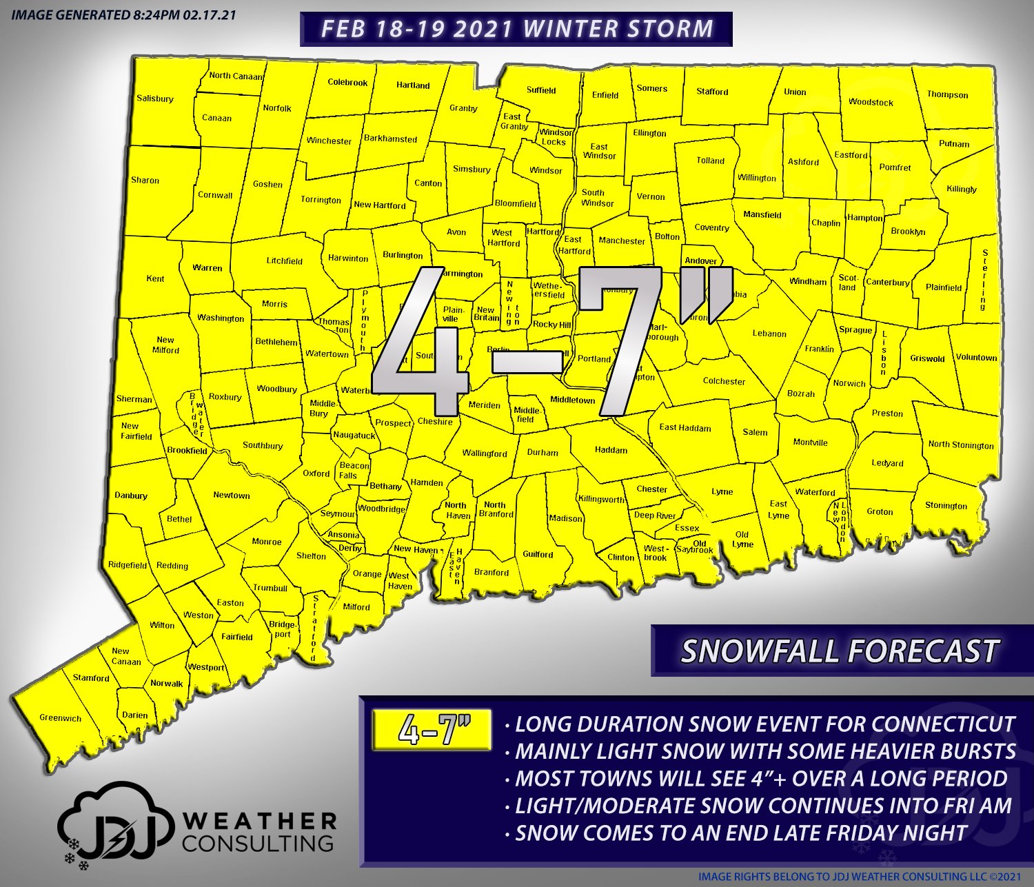
3-6" in all of the southern third of CT
-
3.3" in 3 hours snow/sleet mix
-
ya CT is doing very well between 40-50" besides the NW hills and SE snow hole
-
Lol don't you guys have like 60-70 in the ORH area already?
-
Good to see some of the goods got up to you guys in northern New Haven county.
-
Very heavy snow along I-95 to the merritt, plenty of accidents. Looks like 2" per hour rates there. We are just north of the band getting rates .5-1" per hour. High impact storm for the 95 corridor.
-
possibly sleet though for the "last band"
-
2" 12:15 pm. Hoping to get 3-4" from round 1.
-
Yes also the mount holly radar has more of a NE motion while Upton radar is much more of a ENE motion.
-
Damn sorry, hopefully it spreads north for all, I'm a bit surprised by this, perfect snow growth slowing in on 1" in the first 45 minutes.
-
Absolutely puking snow here 1"+ per hour radar to the south west looks much better than I thought.
-
Final call.
-
Yup
-
Gfs gets it done for most slowly. Not pretty though.
-
exactly, right now I'm sitting pretty but I dont feel comfortable being 36-48 hours out
-
crickets...
-
Snow output the same bc it's colder, older runs had us mixing.
-
Many big hits on EPS
-
Ya doesn’t look as bad , and so far we are much colder than modeled, let’s hope we take the way under , luckily dews will be dropping.
-
Guidance has everyone in CT shooting to 50 this afternoon.
-
American guidance vs the world
-
9-12 hours for some with temps 45-55. 84 south and east left with some patches of 1-3" snow pack