Sey-Mour Snow
-
Posts
5,134 -
Joined
-
Last visited
Content Type
Profiles
Blogs
Forums
American Weather
Media Demo
Store
Gallery
Everything posted by Sey-Mour Snow
-
Down 3 degrees 34.4 light to mod snow
-
Temp down 2 degrees in 10-15 min. Steady snow small flakes. 35.7/31
-
vis dropping actually very breezy
-
Started as snow here. 37/29
-
how far are you from the water?
-
NYC surprise already. Temps down from 38 to 33 in brooklyn with colder surfaces accumulating already.
-
-
Ya tomorrow looks just a bit earlier and a bit colder maybe a coating to an inch squall type.
-
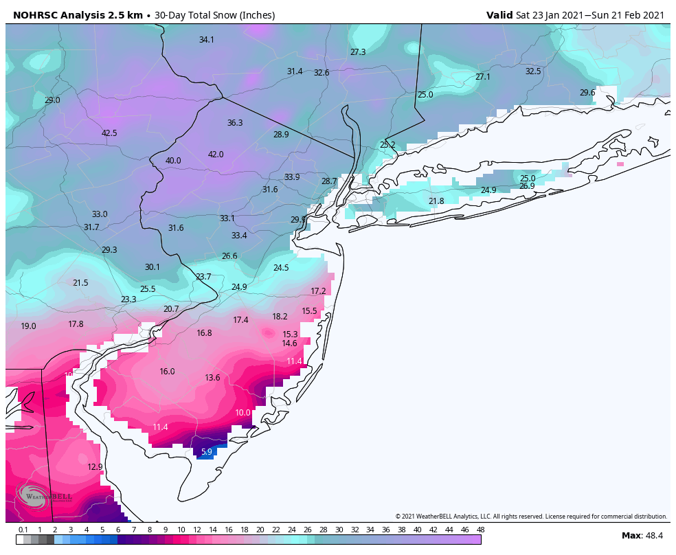
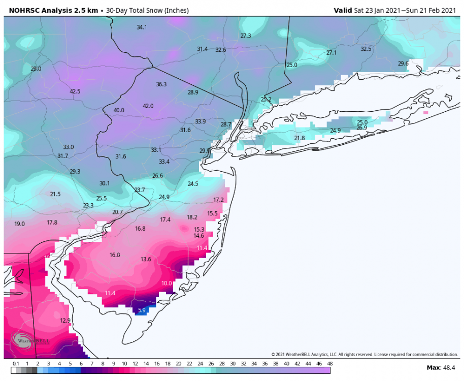
that area in north and central jersey seems to be the jack every single storm this month. There is a 50 square mile area that has 50"+ already not counting 3-6" from today possible.
-
it definitely is, we are right on the line, will be interesting, almost no chance for accumulation for most of CT east of 91 besides the NE hills. however much of western CT has a chance at something, we watch.
-
Have you noticed the squalls tomorrow midday?
-
Snow coming down heavy in central and northern New Jersey and starting to stick on roads with heavier rates even with temps 34-36. Snow growth looks amazing on HRRR in that area.
-
only issue is HRRR is about 5 degrees too cold for my area right now..
-
36.7 here, definitely on the warmer side of guidance.
-
Reports from south central Jersey are encouraging, folks expecting all rain are getting heavy snow, snowing with temps 35-38 then wet bulbing down near freezing.
-
35.6" this month would be nice to finish off at 40" somehow 5-10% chance at my elevation between today and tomorrows squall to get 40".
-
I agree plus one burst of snow tomorrow AM then we should melt this 23 day pack away pretty easily.
-
Yes seems the colder trends coincide with faster arrival of precip which doesn’t allow surface to warm as much. SPC mesoanalysis surface wet bulb is very cold still.
-
Well then .. 12 HRRR.. Most mets would hope thats wrong in CT .. Although the inner snow lover would love to see that happen.. 2" per hour for 1-3 hours across much of CT as heavy snow causes dynamical cooling.
-
Ok great thanks!
-
I figured, usually cool foggy and misty right? Are there any nice days there in the late spring?
-
Asking for a friend.. Anyone from the Cape Cod crew, whats the weather usually like in Martha's Vineyard first week of June?
-
3.3, .8, 1.5 and counting.. 5.6” storm total should get about 6”
-
True, how about wiz, where does he live?
-
The quiet corner.