Sey-Mour Snow
-
Posts
5,134 -
Joined
-
Last visited
Content Type
Profiles
Blogs
Forums
American Weather
Media Demo
Store
Gallery
Everything posted by Sey-Mour Snow
-
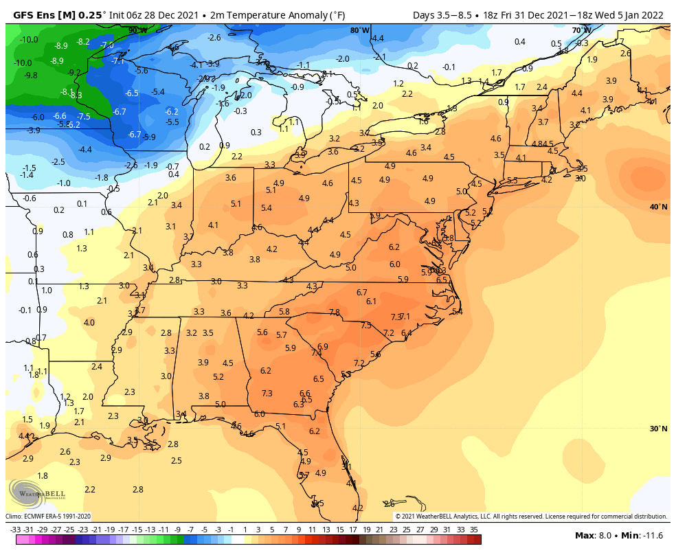
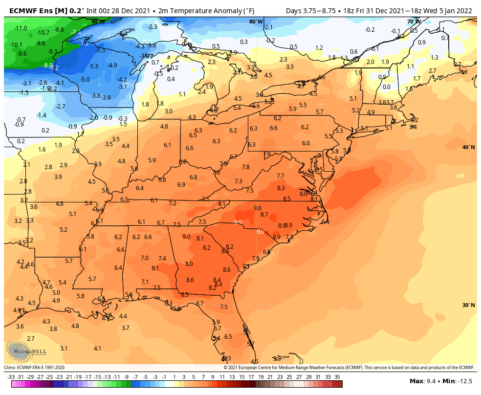
Oh we torch again. Looks like 2-4 days in the 50s before we hopefully get some real cold post Jan 8/9.


-
We torch after that pretty good looks like hope now is post January 9 west coast trough moves east. 12 days out again
-
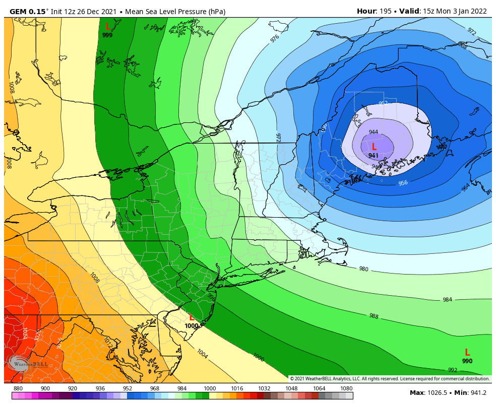
GFS way south with the Jan2/3 threat . Congrats DC. Very nice Hit north of 84 though for first wave Jan 1.
-

-
Getting some icing now 29.7.
-
Let’s separate some of the talk about post Christmas with some talk only about the icing concerns here.
-

December 2021 Obs/Disco...Dreaming of a White-Weenie Xmas
Sey-Mour Snow replied to 40/70 Benchmark's topic in New England
Wow maybe 2-4”. So jelly -
December 2021 Obs/Disco...Dreaming of a White-Weenie Xmas
Sey-Mour Snow replied to 40/70 Benchmark's topic in New England
Radar looks great from about you to foxboro the next several hours I bet you pick up 2-3” -
December 2021 Obs/Disco...Dreaming of a White-Weenie Xmas
Sey-Mour Snow replied to 40/70 Benchmark's topic in New England
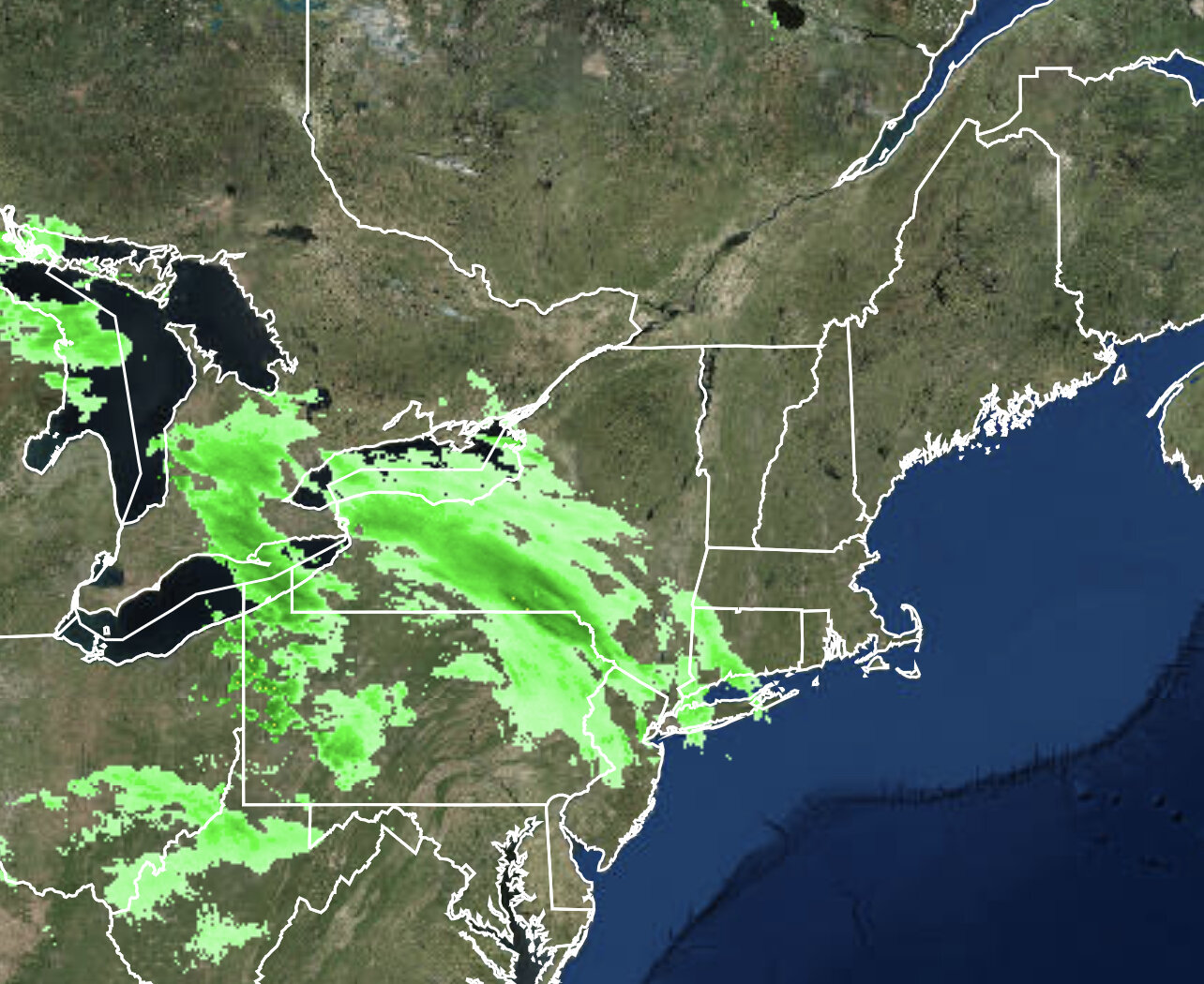
9pm HRRR forecast radar vs actual 9pm radar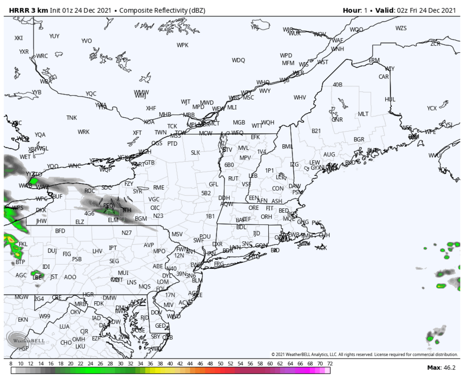

-
December 2021 Obs/Disco...Dreaming of a White-Weenie Xmas
Sey-Mour Snow replied to 40/70 Benchmark's topic in New England
I know, we just got fooled once a few days back with the big push east, so I'm bitter now with the EPS, it was nice to see that instead of a rebuilding West Coast mega trough at 360 though. -
December 2021 Obs/Disco...Dreaming of a White-Weenie Xmas
Sey-Mour Snow replied to 40/70 Benchmark's topic in New England
Christmas miracle for us? -
December 2021 Obs/Disco...Dreaming of a White-Weenie Xmas
Sey-Mour Snow replied to 40/70 Benchmark's topic in New England
HRRR went from 0.00 to .1" + of liquid last 2 runs for a good chunk of CT -
December 2021 Obs/Disco...Dreaming of a White-Weenie Xmas
Sey-Mour Snow replied to 40/70 Benchmark's topic in New England
Wow just checked it out. You think this has some legs, radar looks pretty solid in the lakes. -
December 2021 Obs/Disco...Dreaming of a White-Weenie Xmas
Sey-Mour Snow replied to 40/70 Benchmark's topic in New England
I'd be ecstatic. -
December 2021 Obs/Disco...Dreaming of a White-Weenie Xmas
Sey-Mour Snow replied to 40/70 Benchmark's topic in New England
Ya what’s up with that, it’s like 1-3/2-4”?? Must be drunk? Nothing else is remotely that juicy. -
December 2021 Obs/Disco...Dreaming of a White-Weenie Xmas
Sey-Mour Snow replied to 40/70 Benchmark's topic in New England
Ya I was looking at that for a brief window around New Years as the PNA spikes briefly and it isn’t in clown range. -
December 2021 Obs/Disco...Dreaming of a White-Weenie Xmas
Sey-Mour Snow replied to 40/70 Benchmark's topic in New England
Don’t believe it for a second plus 300 hours -
December 2021 Obs/Disco...Dreaming of a White-Weenie Xmas
Sey-Mour Snow replied to 40/70 Benchmark's topic in New England
The 12z/00z drop off from 6z/18z seen again on Euro for tonight. -
December 2021 Obs/Disco...Dreaming of a White-Weenie Xmas
Sey-Mour Snow replied to 40/70 Benchmark's topic in New England


-
December 2021 Obs/Disco...Dreaming of a White-Weenie Xmas
Sey-Mour Snow replied to 40/70 Benchmark's topic in New England
Yup. -
December 2021 Obs/Disco...Dreaming of a White-Weenie Xmas
Sey-Mour Snow replied to 40/70 Benchmark's topic in New England
Seems suspect, idk what’s up with the same BS with Euro 6z and 18z being amped up? Weird -
December 2021 Obs/Disco...Dreaming of a White-Weenie Xmas
Sey-Mour Snow replied to 40/70 Benchmark's topic in New England
Wow PNA off the charts next week. They go to -6 sigma -
December 2021 Obs/Disco...Dreaming of a White-Weenie Xmas
Sey-Mour Snow replied to 40/70 Benchmark's topic in New England
You are in the best spot, 1-2" likely for you. Hoping for a coating here. -
December 2021 Obs/Disco...Dreaming of a White-Weenie Xmas
Sey-Mour Snow replied to 40/70 Benchmark's topic in New England
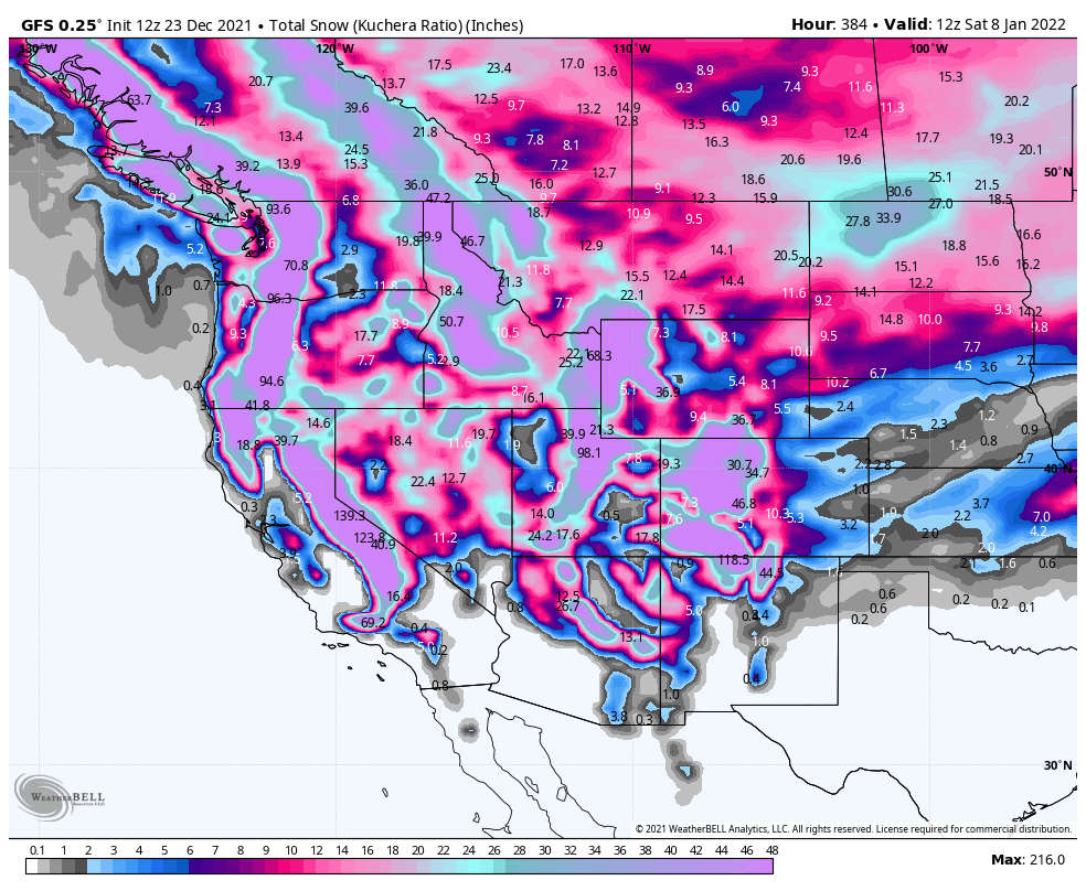
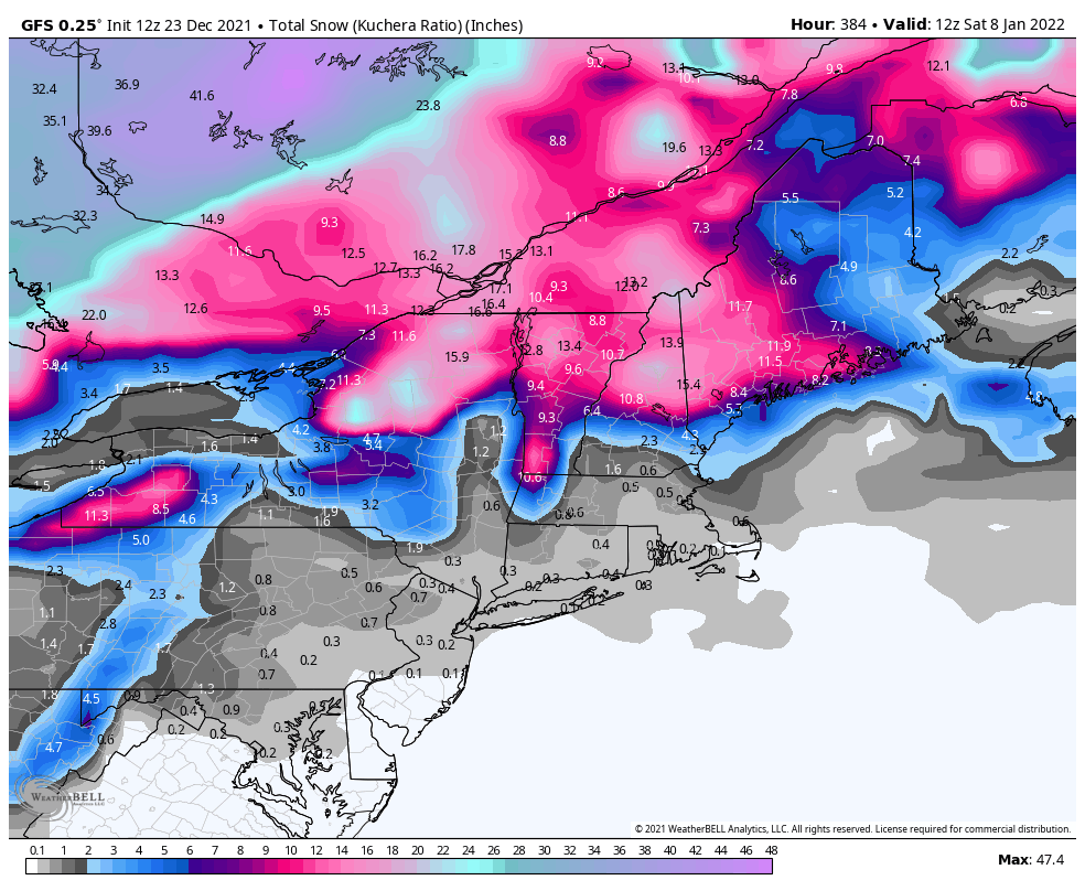
The pattern doesn't look good at all through January 7th, the -PNA from hell just keeps on reloading through the end of each global ensemble run which is January 8th at this point. -
December 2021 Obs/Disco...Dreaming of a White-Weenie Xmas
Sey-Mour Snow replied to 40/70 Benchmark's topic in New England
I know, let’s hope it spreads south a bit more to me too.