wxsniss
Members-
Posts
5,788 -
Joined
-
Last visited
Content Type
Profiles
Blogs
Forums
American Weather
Media Demo
Store
Gallery
Everything posted by wxsniss
-
December 5-6, 2020 Storm Observations and Nowcast
wxsniss replied to Baroclinic Zone's topic in New England
Thank you for that. That is so refreshing. Only the best here, including you, Walt, and some others, are confident enough to admit when they were wrong and understand why. Attributing incorrect forecasts to weenie maps across the board is a tiresome narrative. Career NWS mets, actually putting up concrete maps, and to an audience of hundreds of thousands, got this and other storms wrong, and it's not because they were rip-reading weatherbell maps. There were plenty of red flags that we can point to in hindisight. As always, a confluence explains the bust. Last night we actually mentioned that the best omega was well below the DGZ in eastern SNE throughout most of the event --- but maybe we dismissed that as generating poor but not inadequate snowgrowth. We've certainly overcome that in other storms. A stinger never really materialized. We've certainly had past storms overcome marginal airmasses with good dynamics, and maybe this just did not pack enough punch. Not a single person here would have said Northborough would end up with 1.5". Even Lunenberg managed only 6.5" lol. -
December 5-6, 2020 Storm Observations and Nowcast
wxsniss replied to Baroclinic Zone's topic in New England
Thanks Jerry I’ll find out soon enough if love of weather is inherited or learned -
December 5-6, 2020 Storm Observations and Nowcast
wxsniss replied to Baroclinic Zone's topic in New England
Looking back... GFS actually looks like it may have had the most accurate progs. Check out 0z run 12/5 was very close to reality. NAM / Euro under-weighed the low level warmth, and also were too dynamic... including runs yesterday and 0z 12/5 right up to gametime. RGEM atrocious, furnace and was still more wrong than the rest. -
December 5-6, 2020 Storm Observations and Nowcast
wxsniss replied to Baroclinic Zone's topic in New England
That's exactly why I raised the thundersnow example... has nothing to do with garbage airmass or weenie 10:1 maps. We had several instability profiles posted yesterday, talk of CSI, multiple Mets and AFDs that mentioned the possibility if not likelihood of thunder over central MA. It's just one objective measure that did not pan out. Not at all a complaint, and nothing you or anyone here can control, maybe unless you're a plow driver NWS forecasts will bust too high for large portions of SNE, but this was a fun early season storm in the books. -
December 5-6, 2020 Storm Observations and Nowcast
wxsniss replied to Baroclinic Zone's topic in New England
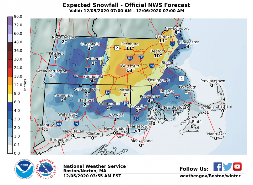
Fun storm, but no way my 3-6 (or NWS 4-8) for Boston area verifies seeing as we are in the CCB now and it’s underwhelming. I get the disappointment. Take aside the well anticipated poor snow growth and melting, it still overall seems less dynamic than most guidance progged. Even for ORH hills and north, seems it underperformed. Did we even have a single report of thundersnow anywhere? -
December 5-6, 2020 Storm Observations and Nowcast
wxsniss replied to Baroclinic Zone's topic in New England
Yeah winds gusting out of NW more than N already... can see low center on radar almost at KBOS latitude 21z HRRR still strong through 8pm or so for metrowest... obviously best will be north shore As expected, the crappy ratios 5:1-7:1 and melting aren't helping sensible accums -
December 5-6, 2020 Storm Observations and Nowcast
wxsniss replied to Baroclinic Zone's topic in New England
Did your old neighborhood (currently mby) have underground power lines? And your current neighborhood? I understand underground lines significantly minimize risks of weather outages, but they're expensive to maintain and repair. We lost power for ~ 8 hours last night... not fun, especially with an infant. -
December 5-6, 2020 Storm Observations and Nowcast
wxsniss replied to Baroclinic Zone's topic in New England
-
December 5-6, 2020 Storm Observations and Nowcast
wxsniss replied to Baroclinic Zone's topic in New England
Went from rain to heavy snow in about 120 seconds -
December 5-6, 2020 Storm Observations and Nowcast
wxsniss replied to Baroclinic Zone's topic in New England
First flakes Brookline Village 3:50pm -
December 5-6, 2020 Storm Observations and Nowcast
wxsniss replied to Baroclinic Zone's topic in New England
Brookline (lower elevation than Jerry)... you can hear it, still can’t see it -
December 5-6, 2020 Storm Observations and Nowcast
wxsniss replied to Baroclinic Zone's topic in New England
-
December 5-6, 2020 Storm Observations and Nowcast
wxsniss replied to Baroclinic Zone's topic in New England
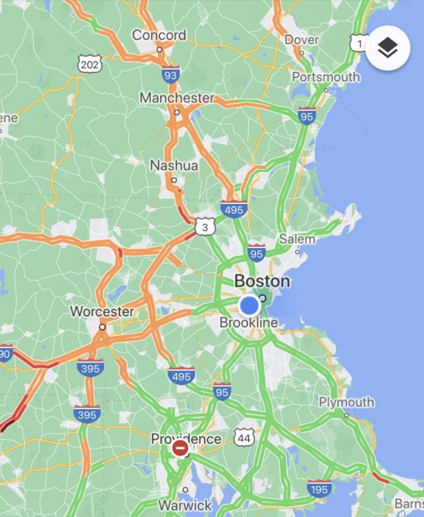
R/S advance slowed inside 128 BombsAway‘s Google Map trick is pretty accurate: -
December 5-6, 2020 Storm Observations and Nowcast
wxsniss replied to Baroclinic Zone's topic in New England
-
December 5-6, 2020 Storm Observations and Nowcast
wxsniss replied to Baroclinic Zone's topic in New England
Thanks Dendrite I'm assuming all snow parallels somewhere NW of that line (i.e. melting producing rain/mix is occurring below 1500ft, and that sub-1500 ft warm layer is further northwest than the bright band). Matches with that report of mixing in Framingham... did not think we'd breach well into 495 by 18z. Areas between 495 and 128 look to rock in a few hours. -
December 5-6, 2020 Storm Observations and Nowcast
wxsniss replied to Baroclinic Zone's topic in New England
Just catching up (ironically we lost power before the storm courtesy of Eversource, now back)... Friends in Tyngsboro reported 100% snow at 11:30am No question we are ahead of changeover schedule in many places How accurate is dual-pol here? That seems too good to be true / maybe it pivots further northwest before it collapses eastward? -
December 5-6, 2020 Storm Observations and Nowcast
wxsniss replied to Baroclinic Zone's topic in New England
13z HRRR continues to clobber all the way to coast eastern SNE -
Dec 5/6th major coastal/ west Atlantic cyclogenesis ...?
wxsniss replied to Typhoon Tip's topic in New England
-
Dec 5/6th major coastal/ west Atlantic cyclogenesis ...?
wxsniss replied to Typhoon Tip's topic in New England
WSW expanded to include Boston -
Dec 5/6th major coastal/ west Atlantic cyclogenesis ...?
wxsniss replied to Typhoon Tip's topic in New England
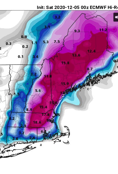
6z NAM actually a tic west and warmer than 0z, also maybe a hair faster exit... better for NNE folks, not as good for eastern SNE Still would support a sloppy 2-4" to Boston metro Spots of 20+ in NH, ME -
Dec 5/6th major coastal/ west Atlantic cyclogenesis ...?
wxsniss replied to Typhoon Tip's topic in New England
Let's revisit 7pm tomorrow to see if the changeover has not happened in Boston metro. Haven't seen anyone here tonight say they are expecting the 10:1 snow maps. Likewise, surely you're not claiming the SV maps you posted with 2-4" in ORH is likely. -
Dec 5/6th major coastal/ west Atlantic cyclogenesis ...?
wxsniss replied to Typhoon Tip's topic in New England
Agree, the literal clown maps aren't happening with this antecedent airmass (unless of course this continues to trend east / slower exit). But I'm increasingly confident in 3-6" for Boston metro. Was also thinking earlier about Ray's map that northeast MA could be underdone if exit is prolonged. -
Dec 5/6th major coastal/ west Atlantic cyclogenesis ...?
wxsniss replied to Typhoon Tip's topic in New England
Also the dryslot issues 18z-0z seen on earlier runs are gone... 18z and 0z shown here: -
Dec 5/6th major coastal/ west Atlantic cyclogenesis ...?
wxsniss replied to Typhoon Tip's topic in New England
One reason for bigger totals in eastern SNE is slower exit -
Dec 5/6th major coastal/ west Atlantic cyclogenesis ...?
wxsniss replied to Typhoon Tip's topic in New England


