

wxsniss
-
Posts
5,520 -
Joined
-
Last visited
Content Type
Profiles
Blogs
Forums
American Weather
Media Demo
Store
Gallery
Everything posted by wxsniss
-
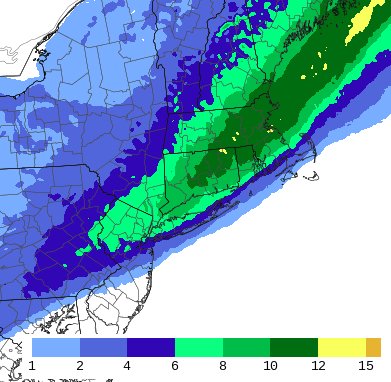
Didn't TWC name this storm Scott? 0z Euro jackpots Weymouth / south shore area with > 12"
-
0z Euro and 5z HRRR: 8z-11z period pummels BOS-PVD corridor and southeast, growing confidence for widespread 10-12 with some pops above in that area Verbatim mix line does not reach PYM
-
Same lol... rates are relatively light now and guidance has really honed in with excellent consensus... there's not much uncertainty on what's to come so might be a good window to force a 2 hour nap 4z HRRR steady with the mix line, barely kisses PYM... that's in less than 5 hours so I think Boston area / south shore are good, Plymouth might briefly be a battleground
-
You doing all nighter? I'm debating sleeping until 2:30
-
Got it, thanks for the explanation
-
0z HREF not backing down... and spots of 12"+ in that zone south of Boston to NW CT:
-
That makes sense. I assumed it was just upper level difluence but the directional circulation to it makes sense. So hypothetically if the region of interest is in the left entrance, would the jet streak have the opposite (i.e. inhibiting effect) due to sinking the warmer/moist air on the equatorward side?
-
Harv tonight went widespread 7-10:
-
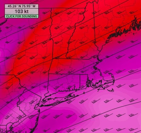
Hadn't noted this before, mentioned on Box AFD... assisting lift is SNE being in RRQ of an H3 jet streak:
-
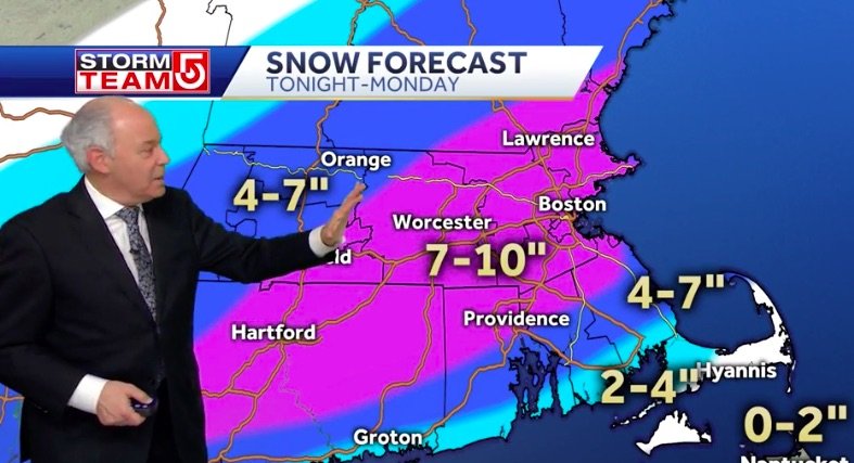
Box 10pm AFD: Presently, H9-7 frontogenesis / deformation coincident with high radar returns over the Delmarva Peninsula into NJ while H7-6 frontogenesis was contributing to a SW-NE snow band over PA into Upstate NY. These two element coinciding and colliding over S New England as we move towards the morning hours beneath broader diffluence aloft with the right rear quadrant of an H3 jet streak aloft, concern of higher QPF values and snowfall amounts subsequent. There are low probabilities within the HREF of +12" amounts over E MA, while forecast model omega values within the dendritic growth zone are notably stronger into the early morning hours on Monday, values upwards of 30 microbars per second as low-level convergent forcing is squeezed by upstream forcing yielded by mid-level impulse energy sweeping through the base of the tropospheric polar vortex, i.e., an arctic front. But, as alluded to by the prior forecaster, there are some snow- fall losses ongoing as 2m temperatures continue to cool with snow onset, the column continues to moisten, dry air becomes less of a concern ... altogether, initial issues with snowfall accumulation. Opted to blend the latest high-res forecast with the prior. This pushes a bigger area of 8 to 10 inches with localized heavier amounts that could push slightly above 10 inches.
-
Flurries in Brookline (Coolidge Corner) 35/30
-
Perhaps a Coastal Storm on March 2nd for SNE????
wxsniss replied to USCAPEWEATHERAF's topic in New England
Thanks Ray. My map busted just as badly and I wrote some tail-between the legs emails to coworkers when the writing was on the wall Friday night. It was a tough forecast, and maybe in retrospect it should not have been. I think we (and essentially 100% of posters here Mets and hobbyists and water-vapor-watchers alike, and lots of TV forecasters, and NWS) were heavily influenced by guidance which across the board was a disaster. Literally everything from ensembles 2-3 days before to Euro (had warning eastern 1/3 of MA < 24 hours before onset) to mesos and short term hi-res models (Sat 9z HRRR was literally showing 0 snow north of Boston just 6 hours before there was 3" on the ground) had one of the worst performances I can remember. Complete blind dart board performance. I acknowledged the warning flags with my forecast (buckshot diffuse vorticity, convection sliding east and robbing moisture influx, not much kink in flow), but the guidance seemed plausible and we've had cases when vorticity consolidates just right and a system amps more than progged. -
Perhaps a Coastal Storm on March 2nd for SNE????
wxsniss replied to USCAPEWEATHERAF's topic in New England
2.7" final in mby Walt Drag posting... I feel like Tom Brady just casually joined my pickup football game -
Perhaps a Coastal Storm on March 2nd for SNE????
wxsniss replied to USCAPEWEATHERAF's topic in New England
2-3 should do it for Boston area, not seeing much back building to sustain accumulating snow much longer Clawing our way to the mean... hopefully Sunday is a nice chunk play to get us closer -
Perhaps a Coastal Storm on March 2nd for SNE????
wxsniss replied to USCAPEWEATHERAF's topic in New England
Congrats to southwest CT folks, sounds like the one area that may actually be a positive bust -
Perhaps a Coastal Storm on March 2nd for SNE????
wxsniss replied to USCAPEWEATHERAF's topic in New England
10:08 am update: -
Perhaps a Coastal Storm on March 2nd for SNE????
wxsniss replied to USCAPEWEATHERAF's topic in New England
Glad those HRRR runs from literally just 4 hours ago (9z!) are failing badly... they showed a shutout pretty much north of Boston. Serviceable snowfall to make it look wintry again. Snowgrowth not the best but densely falling at the moment, looks like lower level lift on soundings. -
Perhaps a Coastal Storm on March 2nd for SNE????
wxsniss replied to USCAPEWEATHERAF's topic in New England
Unbelievable... HRRRs are trending towards a shutout northern MA, maybe even north of Route 2 (9z HRRR) That convective blob I circled earlier in the night way off the coast of NJ... not only is it tugging the surface low center east, it’s robbing moisture inflow... to CoastalWx’s comment about depriving 850 influx even if we get a briefly closed H7 Hard to believe there’s a complete shutout looking at radar, but still a big shift from even a few hours ago This has been a debacle for the entire model suite, ensembles down to hires short term guidance -
Perhaps a Coastal Storm on March 2nd for SNE????
wxsniss replied to USCAPEWEATHERAF's topic in New England
0z Euro southeast by a good amount... warning limited to Cape, advisory southeastern 1/2 of SNE -
Perhaps a Coastal Storm on March 2nd for SNE????
wxsniss replied to USCAPEWEATHERAF's topic in New England
There really is tons of convection blowing up over southeast PA heading northeast... that would be a great sign... problem is how much this stuff circled below yanks everything east Greatest pressure falls are also by SEPA / NJ... not much and those can jump around but if we can continue that, we may have something going...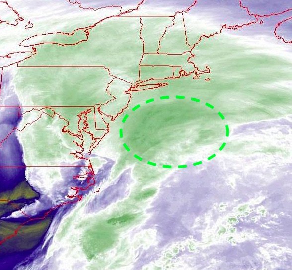
-
Perhaps a Coastal Storm on March 2nd for SNE????
wxsniss replied to USCAPEWEATHERAF's topic in New England
The main post-mortem reasons were there from the beginning: - flat H5 with barely a kink in the flow - diffuse piecemeal vorticity that never really consolidates The 18z models Thurs showed how it could possibly all work out, and we’ve been selectively looking to corroborate that since... Another wishful WV watch (I remember Tip mocking us for some late night vigils we held with Messenger hoping for satellite / radar trends that never materialized). Sometimes they do pay off. I criticize myself for getting swept in the groupthink... like “convective feedback”, we collectively chase overconfident posts and go down a track that might be wrong. To be fair, lots of maps out there may bust high including NWS. And overall pretty piss poor performance by all guidance, ensembles to short term hi res models. -
Perhaps a Coastal Storm on March 2nd for SNE????
wxsniss replied to USCAPEWEATHERAF's topic in New England
There’s not a single bit of evidence or guidance at this point that this is ramping up... Yeah this feels like a classic Messenger fade-away event, RIP Diffuse and piecemeal vorticity, plus a relatively flat H5... it was a gamble to expect that this would surprise and consolidate north, based on yesterday’s 18z-0z suite showing “its possible!” So we latched on, but everything has been trending worst since then 18z Euro was still a decent event with warning all of southeast MA... not a good performance as it looks now -
Perhaps a Coastal Storm on March 2nd for SNE????
wxsniss replied to USCAPEWEATHERAF's topic in New England
Yeah I liked your map. I’ve been hedging around a 4-8/6-12 Boston south all day so went with 5-10. It’s pretty much a Euro/GFS blend with some recognition of mid level features. I’ll be nervous for both of us... I think we know by 1-2am tnite where this is headed. If this tugs east, the western zones and maybe even northeast MA may bust too high. Hopefully this goes ballistic and I’ll gladly bust low. -
Perhaps a Coastal Storm on March 2nd for SNE????
wxsniss replied to USCAPEWEATHERAF's topic in New England
ORH I put in 4-7"... I definitely could bust low (and get discontinuous snowfall gradients in subsidence areas) if a strong deformation band forms and drops anchor -
Perhaps a Coastal Storm on March 2nd for SNE????
wxsniss replied to USCAPEWEATHERAF's topic in New England
Some crap free PaintBrush program... started using it on the Wed event... figured I'm spending so much time analyzing and predicting and commenting, I might as well toss up a map.

