wxsniss
-
Posts
5,520 -
Joined
-
Last visited
Content Type
Profiles
Blogs
Forums
American Weather
Media Demo
Store
Gallery
Everything posted by wxsniss
-
Happy Birthday Jerry! A real pain forecast, less because of rain-snow issues and more because of complex evolution. Great disco everyone. Some thoughts: Likely oversimplified, but the way I view this entire system of "round 1", "round 2", and in between, is a stretched out and messy secondary coastal transfer. What we're calling "round 1" is still part of WAA associated with the primary low over the Lakes. Yes, 2ndary surface reflections start to pop up by 0z Mon (when the round 1 thump is well underway in SNE and mixing already nearing BOS), but 850 winds are still from the south going all the way back to ~ Michigan. For eastern SNE, IMO the bigger potential snow will be impacts of an eventually dominant 2ndary coastal Monday night - Tues. Powderkeg potential that is not spoiled by round 1. How that develops has been a mess, with multiple pieces of vorticity circling around the ULL, hence multiple surface lows appearing to pop up and bobble back and forth over 24 hours between 0z Mon - 0z Tues. Whichever of these multiple lows dominates will determine how hard we (eastern SNE) get hit by its CCB after 0z Tues in "round 2". Remember this "round 2", even though we are considering it part of the same storm, is still over 24 hours out. I think the baroclinic zone remains closer to the coast and we see bigger impact solutions of a CCB lock in through today. As for a forecast? Easier to separate the different storm parts, and the bigger total numbers of all rounds put together could appear to disappoint if we have 12 hours of lighter rain in between. For the Boston metro area, I'm thinking: 3-6 in round 1, maybe 4-8 in far western burbs... then another 4-8 in round 2 (though I'm much less confident of this for reasons above and its > 24 hours away)... for an event total 7-14. Obviously biggest bust potential is in the CCB round 2 where this could even bust too low if one of the multiple surface lows dominates sooner and closer. Awesome start to met winter!
-
Yep... though in March, this event was the "first child" of winter storms for many of us in SNE.
-
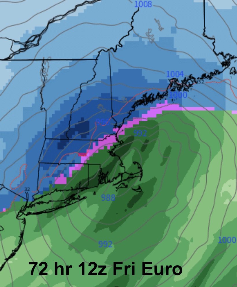
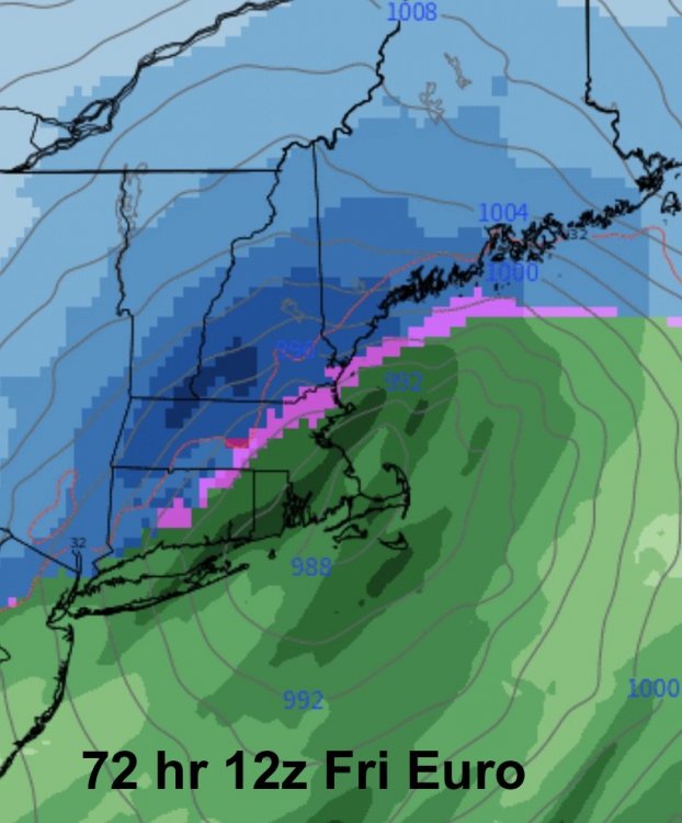
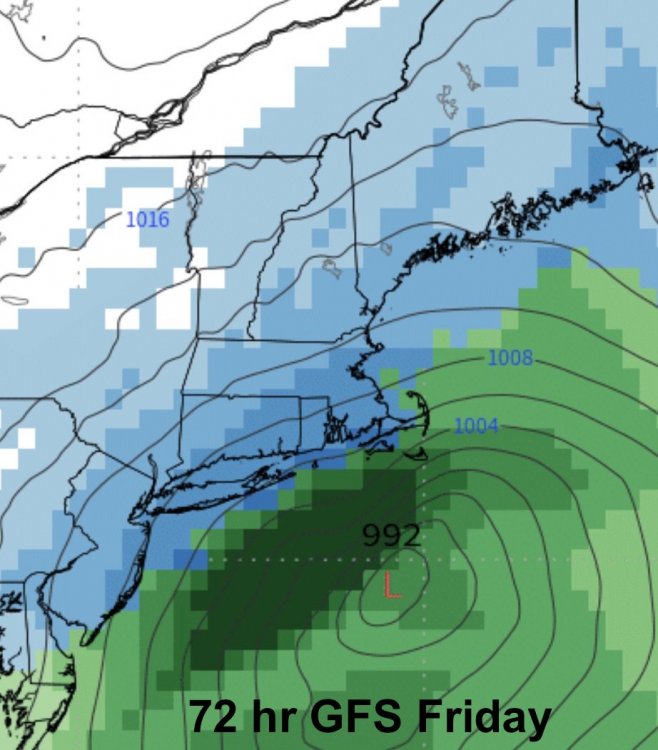
For sure... I couldn't find 24-hour snowfall maps (vs. total snowfall that is hard to distinguish from preceding Fri-Sat event) to capture how (badly) Euro and others did days before. The consensus Friday was that Sunday would be a snow-to-rain mess for most of SNE. I mean, look at this... 72 hour (!) prog of 12z Euro... and ironically, the GFS Friday for the same time:
-
Some post-storm analysis of guidance... nothing really groundbreaking here, we all had a sense the mesos did excellent on this I thought a visual summary of the guidance history could supplement our anecdotal / tired recollection. Major caveat is that this uses only a 10:1 snowfall map. I considered using qpf but I did not think that the captured end result we care about as well (e.g. R/S lines which played a factor), and I do not have a qpf map other than the digital accumulation maps. Also, not sure why but PivotalWeather shreds the 12k NAM 6z/18z runs. As you can see: • Mesos were indeed excellent. 12k NAM / Euro may have been the best in the final 12 hours. • 12k / 3k NAM had the best jack zone of the pike region. Euro / RGEM was always too far south. • GFS was terrible. Way too dry throughout. Completely useless. • ECMWF characteristically made slow incremental changes in the same direction towards the best solution. • RGEM was first to latch on to widespread double digits. Not redeeming a terrible performance most of the season.
-
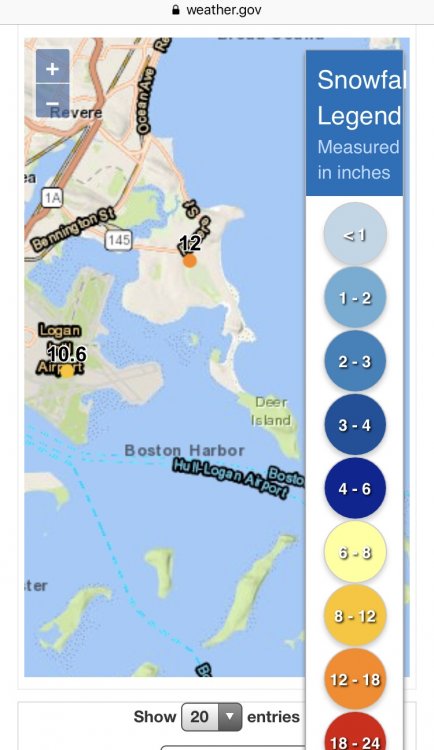
Yeah I was gonna say he will go back to update the 708am measurement later this afternoon... So so frustrating Saw this on weather.gov, 10.6 at Logan... wonder if it’s been updated somewhere... not on the PNS... and who knows anymore, Deer Island, Logan...
-
It sure does. I was gonna write up a post-analysis and assess my forecast map later today. RGEM (inside 12 hours? I'll check), NAM, RPM (last 2 runs), HRRR (when it was within range) crushed an event for once. Even Euro was way too conservative in its 12z/18z runs just before onset, though it had a pretty good distribution. GFS was a disaster even on Sun 18z and only had a clue once the event was already underway Mon 0z... but I correct myself, it's purpose is only for under 6 hour guidance.
-
Shit obs. And by the book, they do not wipe before each measurement. Technically not even the "airport"... that poster earlier said ground crews at Logan were reported foot+
-
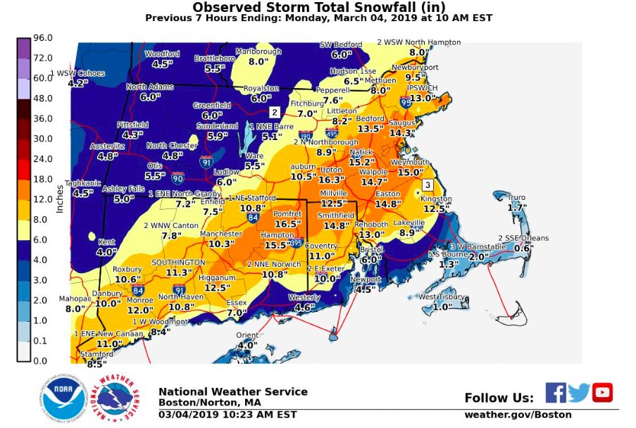
I guess our KBOS measurement woes have not resolved...? ...Suffolk County... South Boston 15.5 918 AM 3/04 Trained Spotter Dorchester 15.5 720 AM 3/04 Ham Radio Chelsea 14.0 815 AM 3/04 Ham Radio Jamacia Plain 13.2 800 AM 3/04 Co-Op Observer Boston 13.0 925 AM 3/04 General Public East Boston 12.1 705 AM 3/04 General Public Logan AP 9.8 708 AM 3/04 Airport
-
-
NAM had this as well last night... residual lift ~ 750 mb moving through until about 10am Nice ongoing activity and I'm pretty sure Logan cracks 10"... having stuck my neck out to so many co-workers (with the same forecast map I posted here yesterday + local details), I care about final numbers at Logan and perception more than I might otherwise
-
Yeah this dessert band really ramped up for Boston, Logan should break 10" for sure... the band further west by Worcester has ramped up a bit as well so we may benefit from that too
-
Agree I get annoyed the media gets a hold of these prelim maps to summarize the storm
-
-
How frequently do you guys clear with each snowfall measurement? And do we know if Logan does? Compaction with this heavy wet stuff is gonna cut down on snow depth
-
And to think most of that 12 was in 5 hours ~2am-7am... Based on those PNS numbers, you would think Logan should be > 10"...
-
Yeah NAM last night was too aggressive pushing the mix line to south shore... HRRR / RAP / Euro / RGEM were excellent and pretty steady on this aspect
-
...Suffolk County... South Boston 13.5 549 AM 3/04 Ham Radio Chelsea 11.0 519 AM 3/04 Ham Radio East Boston 9.7 505 AM 3/04 General Public
-
Weenies that make forecasts to lots of co-workers care lol
-
Lots of compression occurring... let's hope we don't get shanked by the KBOS measurement... that impacts public perception of forecasts
-
You'd want a good memory for a storm that TWC named Scott Heavy wet snow with little wind... this will be a beautiful morning once sun comes out with all these snow-caked trees
-
Wonder if KBOS cracks 10"... they should based on widespread 9-13" reports in metro area, and we should average 1" / hr for another 1-2 hours. Jerry your old hood:
-
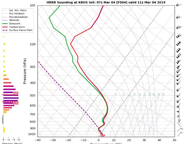
Boston metro folks (and pretty much anyone north shore, 495, south and east)... we are in for a treat! KBOS soundings off 7z HRRR 10z: 11z:

-
Mini-April 1997 under way in that regard (obviously much shorter duration, no widespread thundersnow)
-
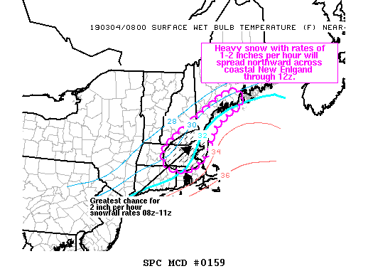
Mesoscale Discussion 0159 NWS Storm Prediction Center Norman OK 0216 AM CST Mon Mar 04 2019 Areas affected...eastern MA...southeast NH and coastal portions of southern ME Concerning...Heavy snow Valid 040816Z - 041245Z SUMMARY...Heavy snow will continue across eastern portions of MA and spread northward across southeast NH into southern portions of coastal ME. Snowfall rates around 1 inch per hour will be common, though rates up to 2 inches per hours are possible locally. DISCUSSION...Heavy snow will continue across eastern MA early this morning and rates will increase with northward extent into southeast/coastal NH and coastal portions of southern ME. Forecast soundings continue to show a saturated profile through a deep dendritic growth zone. Modest forcing for ascent associated with a weak shortwave trough ejecting over the Mid-Atlantic region and a band of 700mb frontogenesis over the region, in conjunction with a deepening surface cyclone moving offshore south of Long Island, will help maximize snow rates through 12z. Generally rates of 1 inch per hour are expected, though locally up to 2 inches per hour is possible, especially from eastern MA into southeast NH. ..Leitman.. 03/04/2019 ...Please see www.spc.noaa.gov for graphic product... ATTN...WFO...GYX...BOX...
-
Good morning everyone, WOW at radar... 7z HRRR brings death band right over Boston metro through 6am Seems to have a good handle of mix line with current CC radar just south of Plymouth, does not advance much further north We should be well on our way to double digits, lots of drooping trees