

wxsniss
-
Posts
5,452 -
Joined
-
Last visited
Content Type
Profiles
Blogs
Forums
American Weather
Media Demo
Store
Gallery
Posts posted by wxsniss
-
-
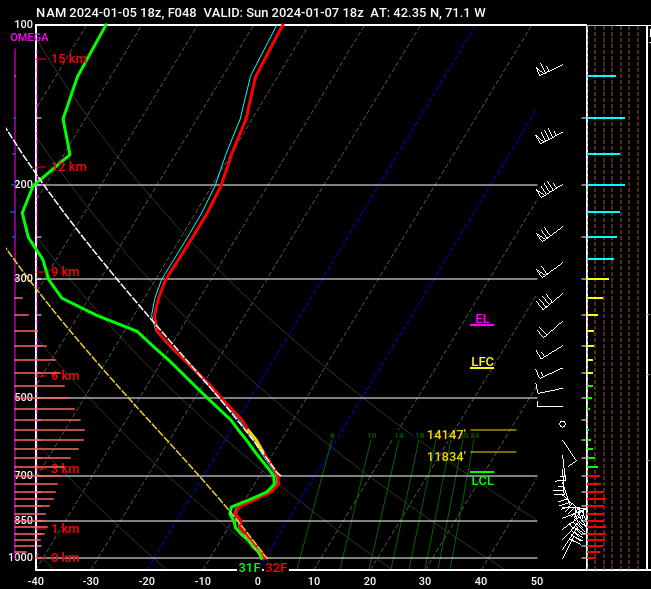
Almost exactly 2 years ago...

Not sure whether the string of ratters for eastern SNE truly represents changing climate or about the AGW attribution, and I dug up the above as a reminder (to myself lol) that classic blockbuster KUs do still happen, and recently.
I've sat out this upcoming storm... busy week + I refuse to dignify what will likely be 1-3" glop in MBY with piecemeal dynamics + garbage soundings + a warm BL.
This system reminds me a bit of the 1/7/24 system waiting for a CCB to cool our BL, except that prior system had a more robust CCB and colder 925-850s. And when the CF moved through, we had 4 hours of magic. Not expecting that Monday.
Still keeping hope Feb/Mar can salvage what has been a brutal season for Boston metro area.
-
 2
2
-
 1
1
-
 2
2
-
-
1 hour ago, Typhoon Tip said:
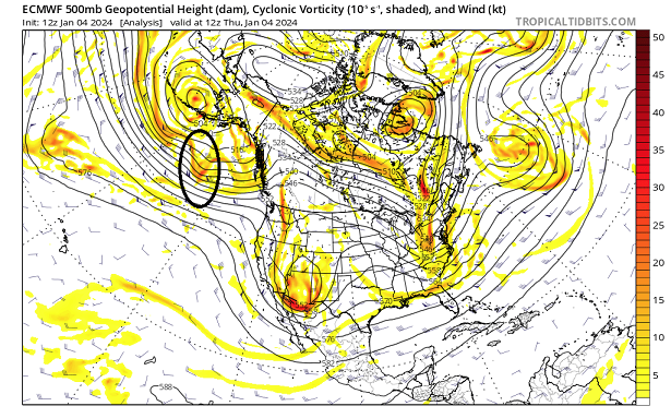
there's been a lot of suggestion toward subsumption phase type - that's just when a S/stream interloping S/W creates a 'place holder' and then the N/stream ( usually the western end of a decaying SPV) fractures and dives in to "eat"/absorbs the S/stream ... the real world expression of that is a deep cyclone resulting - usually exceeding the climate low depth ...
This 12z Euro run is repeating the suggestive leitmotif - but... you can clearly see that speed of the slow is stressing it's ability to phase. The S/stream alllllllmost out paces the interaction domain but just get's caught. But in being stressed it's not as proficient at triggering the deeper solution -
though as is, the fight results in some 30 hours of persistent light to moderate snow and strengthening NE wind so... 6 /a dozen
Just starting to look at this in more depth, but to your point, interesting to see variance on 12z EPS in low depths hinting at the very different ceiling with a "subsume" setup:
Jan 17 range is generally 980s-990s
Jan 19-20 have a few members as low as 950s-960s
-
1
-
-
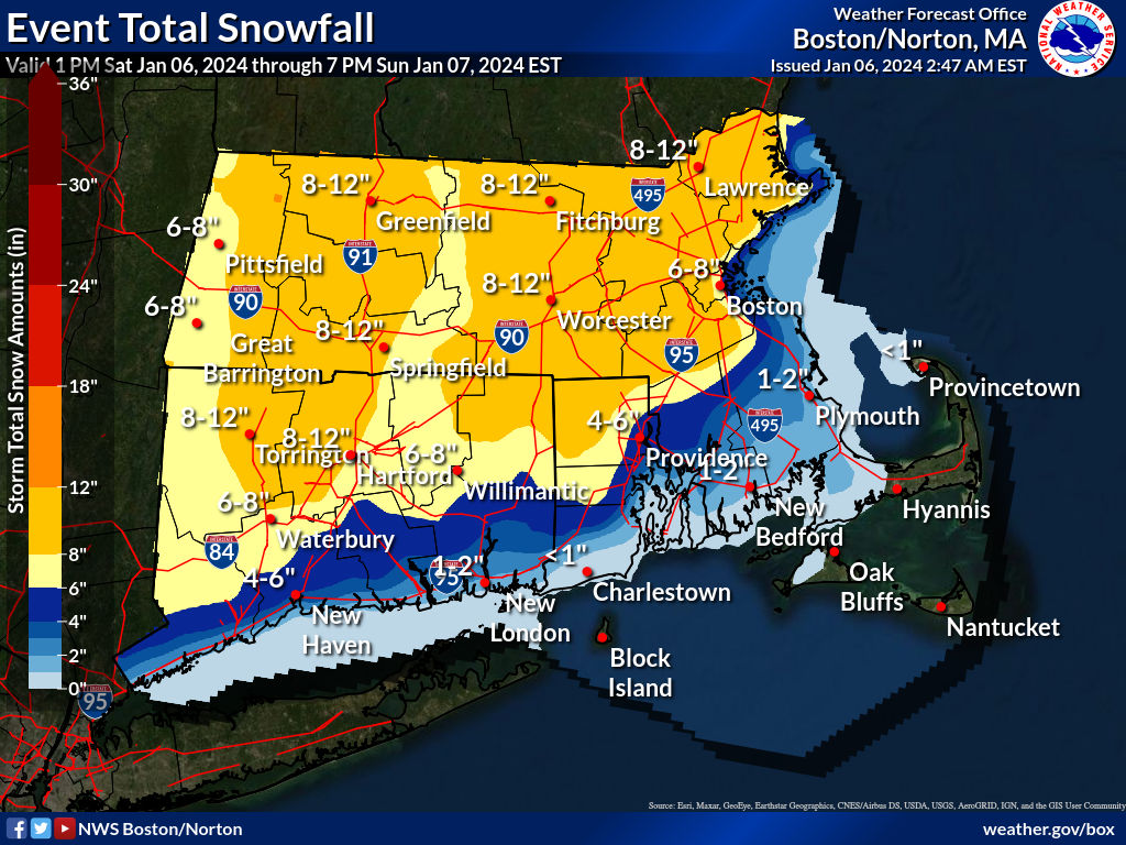
Wasn't able to post all day.
Some thoughts:
Definite disappointment overnight, and one of my worst forecasts for Boston metro (waivered 4-8 vs. 6-10, and though I had posted "not totally enthusiastic about these BL temps" after the Sat 0z NAM, I muted those concerns and rode the 36-48h Euro/NAM/GFS and went 6-10). Embarrassing when those who asked for my forecast woke up to rain and wet roads. We ended up ~4" in Coolidge Corner.
I was confident ORH hills to NEMA would hit double digits.
If you look at final totals map... NWS (and @40/70 Benchmark's map) were extremely good forecasts, but the Boston metro was a discontinuity as if a bite was taken out of the 6-8/8-12 contours.
Nothing about the precarious shortwave interactions or storm track or anything really complex... the BL temps were simply too warm and failed to cool with good rates in the overnight hours (you'll recall the 18z NAM Friday night had us wetbulbing to 32-33 by 4am, and Box AFD even mentioned that as rationale for increasing amounts... we easily would have had >6" if that materialized).
In any case, any frustrations were instantly forgotten once CF passed through ~12pm-5pm. Definite period of >1" / hr rates, huge flakes. Felt like our winter mojo was back. And my toddler excitedly announced to strangers in the grocery store that it was snowing, and got to build his Olaf, so all was good.
-
 1
1
-
-
1 minute ago, 40/70 Benchmark said:
Link that site?
Thanks
I just use Wundermap and drew my own line:
-
1
-
-
-
10 minutes ago, Henry's Weather said:
I will say that the HRRR is trending towards less mixing each run for Boston metro
I saw that as well, hope the trend continues.
6z NAM soundings warmed a tic from 0z at surface holds at 34-35 until ~20z
Current location of CF at MA-NH border, though we have a ways before this collapses:

-
1
-
-
10 minutes ago, 40/70 Benchmark said:
7"
6" from midnight to 3am....heaviest was just south of me, too.
32.0
Nice (I'm jealous of all these amazing reports with barely a coating here)
6z NAM big hit for your area northeast MA / southern NH / eastern ME
CCB with colder BLs has to salvage accumulations for Boston metro, otherwise we struggle to reach the 6"+ calls (NWS still has 6-8"/8-12", I was expecting 6-10")
Below is just 12h 10:1 from 12z Sun-0z Mon:

-
1
-
1
-
-
White rain / snow mix, coating in Brookline
6z HRRR continues a strong commahead finish for ESNE
BLs temps have been a struggle so far and will be pivotal to reach 6"+ in Boston metro.
0z NAM sounding for KBOS is promising we wetbulb to 32F by 9z
vs 6z HRRR has KBOS 36-37 until 20z
-
Sorry if posted earlier... add to the meso side
HREF continues bullish
0z-12z Sun:

12z Sun - 0z Mon:

-
1
-
-
1 hour ago, 40/70 Benchmark said:
I knew I shouldn't have bumped immediate Boston area up at the last moment. I hate weather.
And as is, NWS map still more bullish than yours for Boston metro.
Except for RGEM and CMC, all reliable guidance yesterday was trending colder and more robust CCB. Remember 18z and 0z NAM soundings last night. Your forecast was solid until 12z today. I debated 4-8 vs 6-10, and went 6-10 with last nights guidance. And I dismiss any AWTs… it was a precarious setup, but there were also favorable large scale synoptics that most here bought. These experiences reinforce not releasing a final forecast until hours before.
Anyway, these are silly postmortem thoughts before we’ve even started.
Should still be the best event my area has seen in years.
-
Great runs for southern VT / MA/NH border / southeast ME...
For SNE, snow maps may look decent but point of capture of surface low keeps ticking north, warmer at surface and 925s, and closer dryslot in morning... both NAM/GFS warmer compared to 0z last night, not good for the higher totals in SNE... I'm hoping these trends reverse a little
-
2
-
-
18z HRRR still very warm at surface though, it's 33-36 for much of ESNE until ~20z
0z NAM thermals is what we want... it's as if all guidance warmed as soon as Pope posted this morning... I'm hoping we cool back in the 18z suite starting with NAM
-
Just looked, tbh I wasn’t totally enthused with soundings on 12z NAM for eastern SNE
Kbos a tic warmer to 34-36 compared to 32-33 last night through most of event, and the best lift is often below DGZ
The snowfall maps look great but verbatim on that run we’ll be really dependent on rates and robust CCB for the higher amounts
-
1
-
-
Our discussions here tonight identifying colder trends particularly for east SNE are mirroring NWS latest thoughts:

-
1
-
-
10 minutes ago, 40/70 Benchmark said:
Excellent writeup and forecast.
Agree with your bumping up Boston metro from 4-8 to 5-10 given almost all guidance (CMC is outlier).
I won't be shocked to see 12-14 spots in eastern face of Worcester hills to 495 to NE Mass.
Let's hope there won't be too much if any melting lull between overnight WAA and late morning-afternoon CCB.
And no complaints if HREF scores a coup.
-
1
-
-
No drastic changes... a more southeast track and colder thermals throughout, giving a better run for ESNE/coastal CT / RI... colder and wetter
10:1, 12z left, 0z right:


-
1
-
-
Thru 42h continues a tic southeast of 12z run, thermals colder everywhere, otherwise very similar
-
Looks a hair south and east at 30h with colder 925s everywhere
-
4 minutes ago, 40/70 Benchmark said:
Man, I am nervous about busting low....but my map is done. I am just to leery of totally biting off on this damn last minute capture.
Really tough forecast for SNE inside 495 and southeast... not just the capture but the thermals early on... 0z NAM was very cold once things wetbulb, and I think that's notable for a model that tends to be aggressive with warm intrusion.
Hard not to forecast potential for double digits somewhere, most likely Worcester Hills to 495 / northeast MA.
For MBY Boston suburbs... debating 4-8 vs. 6-10, pending trends overnight. I could see a tight gradient where downtown is like 5" whereas Jerry in Chestnut Hill closer to 8-10". And even then there is potential upside to those numbers if overnight is colder and CCB develops faster.
Agree with Pickles I could see a lull Sunday morning ~7am-9am when it's fizzling (even drizzling) between WAA and CCB, before we crank again into afternoon.
-
Just tuning back... everyone in bed, back to storm!
HREF really impressive, even mean snowfall. Anyone know if HREF thermals and/or snow algorithms are less reliable? I ask because mean QPF is very close to NAM, yet HREF has most of ESNE 12-18 mean snowfall.
I do remember clinging to HREF snowfalls that never materialized in past storms, other storms it was pretty accurate.
Warmest mean 2m Temps at 9z Sun:


Snow and QPF are not strictly 10:1 so their algorithm / thermals must be more generous than NAM:

Left: Snowfall, yellow = 12-15, orange 15-18
Right: QPF, light blue 1.2-1.5, purple 1.5-1.75
-
Coordinates for Dorchester just south of Logan, using 18z NAM, at 18z Sun catching CCB...
(and earlier it looks like surface wetbulbs from 36-37 to 32-33 by 3z Sun... ie., cold run for Boston metro that though wet should accumulate):
-
1
-
-
2 wrinkles a little more prominent on this 6z NAM, and I’m thankful we don’t have more time for these to create even more forecasting havoc:
1) interaction of our trailing shortwave with the shortwaves diving down the Midwest
2) convection out east / multi-low structure robbing some of the inflow mechanics… you can see a bit of that hr 51
-
Thanks for updates fellas, haven't had a chance myself to look at any H5 trends...
Seems solutions have stabilized away from the north tics earlier today and all give ESNE at least some CCB treatment, widespread SNE 6-12"
Critical window and probably last opportunity for drastic changes would be 6z-12z guidance as shortwave energy enters BC ~6z Friday
I'll be back for Euro
NWS ticked a bit up at coast on 7pm update:

-
45 minutes ago, Typhoon Tip said:
Do you know that the "2nd S/W" in discussion is still out over the Pacific ocean as of the 12z initialization ?
yes sir -
 That ovoid piece there has to rise up over that shallow ridge axis along the coast, then careens like a bottle rocket all the way around the underside of that S/Wern quasi closed trough while it's opening up and smearing out down stream ... Lot of moving parts and pieces being handled over the next 30 hours. I thought this was on-board as of this morning but when I checked I was flat wrong about that assumption. That's it there. Folks should go trace that themselves...
Hastily catching up on guidance since this morning, sorry if I missed similar posts earlier.
Great post. First energy entered CA ~0z last night. This second piece looks to enter BC ~6z Friday.
We've seen today how sensitive outcomes are to strength of these 2 pieces and timing of interaction. Would not be surprised to see continued volatility in guidance next 24 hours.
-
1
-


It was a Flop... February 2024 Disco. Thread
in New England
Posted
For any newcomers looking for great summaries of climate data including monthly / seasonal snowfall:
http://climod2.nrcc.cornell.edu/
Quick eyeball: 1957-58 had one of the best turnaround of snowfalls for KBOS: 6.7" Nov-Jan, then 38" Feb-April. I'm curious what teleconnectors were at play in the switch if anyone knows.
Also, not a formal statistical analysis, but the most prominent trend is just all the higher maxima beginning 1992-93 (incidentally, the year I arrived in Boston, skewing my expectations forever") ):
):
Seasonal snowfall for KBOS: