wxsniss
-
Posts
5,520 -
Joined
-
Last visited
Everything posted by wxsniss
-
Dec 5/6th major coastal/ west Atlantic cyclogenesis ...?
wxsniss replied to Typhoon Tip's topic in New England
I saw it on boston.com lol... originally posted on their twitter. Yeah I think I've seen it 1 or 2 times before, so I don't think it's generated for most storms. And obviously not written in stone. Will be a fun afternoon nowcasting! -
Dec 5/6th major coastal/ west Atlantic cyclogenesis ...?
wxsniss replied to Typhoon Tip's topic in New England
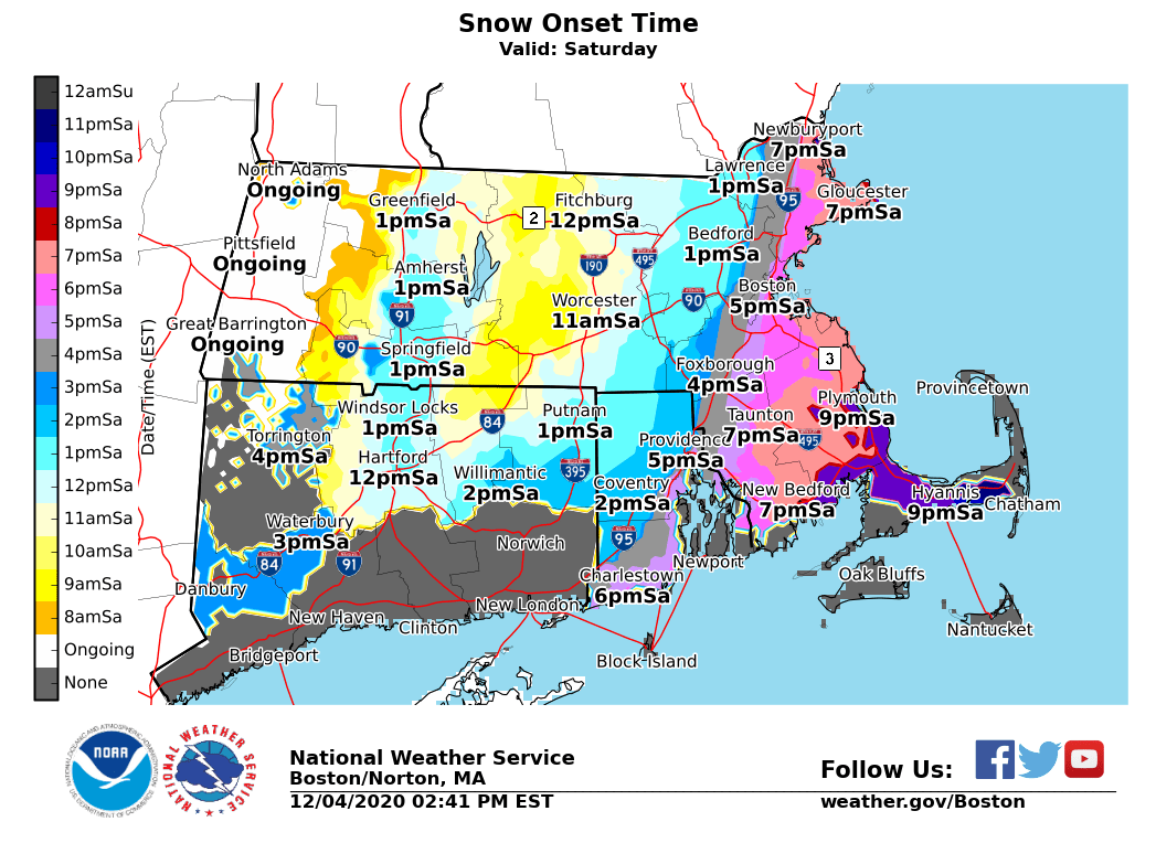
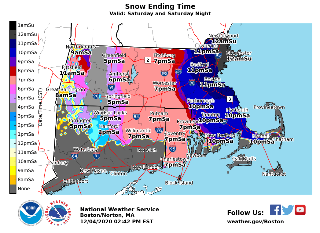
Some NWS maps in case you missed them For Boston metro, flipping an hour sooner/exiting an hour later would be how we can get to 4”+ Some things to watch at 0z, and there was a hint of slower exit on some guidance today

-
Dec 5/6th major coastal/ west Atlantic cyclogenesis ...?
wxsniss replied to Typhoon Tip's topic in New England
All while maintaining dynamics... We were able to thread that needle on some guidance early Thursday. These details still in flux. At the moment I think 2-5" is definitely doable Boston metrowest to 128, coating to 3" southeast. -
Dec 5/6th major coastal/ west Atlantic cyclogenesis ...?
wxsniss replied to Typhoon Tip's topic in New England
-
Dec 5/6th major coastal/ west Atlantic cyclogenesis ...?
wxsniss replied to Typhoon Tip's topic in New England
18z RGEM ticked east, still crazy warm, rain throughout most of SNE -
Dec 5/6th major coastal/ west Atlantic cyclogenesis ...?
wxsniss replied to Typhoon Tip's topic in New England
Yeah the hint of slowdown off the Cape is intriguing for eastern SNE, something to watch in next 12 hours Re: your post on crosshairs... yeah interior eastern SNE (at least 495 and southeast) has never looked ideal in that regard. Best lift is all below DGZ. Snowgrowth might not be optimized, but I'm not familiar if there is something different about stinger mechanics to think that can be overcome. -
Dec 5/6th major coastal/ west Atlantic cyclogenesis ...?
wxsniss replied to Typhoon Tip's topic in New England
These tics make a big difference for Bos metro area coast-128-495... from this NAM run anticipating a changeover somewhere 3-6pm, and an hour here or there will make a difference under those heavy rates Nice to see 18z NAM tic colder Also I think18z NAM slows down the exit a bit -
Dec 5/6th major coastal/ west Atlantic cyclogenesis ...?
wxsniss replied to Typhoon Tip's topic in New England
18z NAM a hair colder than 12z for eastern SNE folks Huge hit for northeast CT-central MA-on northeast -
Dec 5/6th major coastal/ west Atlantic cyclogenesis ...?
wxsniss replied to Typhoon Tip's topic in New England
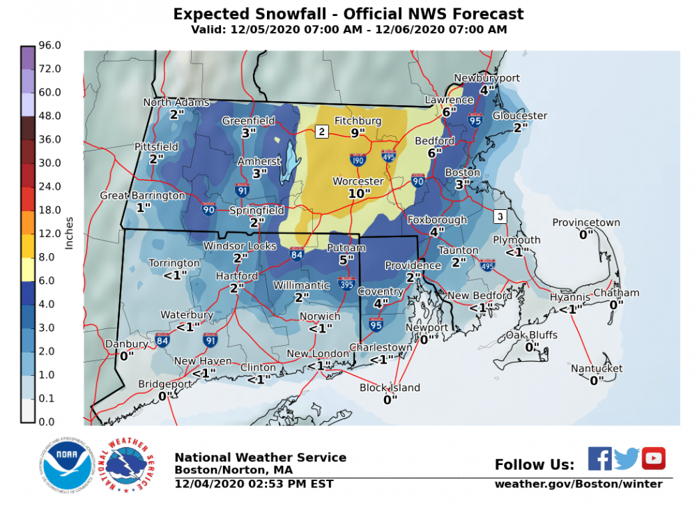
Boston metro (including metrowest) will be fun to watch ~18z-0z Saturday when 850/925 crash <0C, great rates, but surface is still 37C. I think at the very least, a tight gradient of sloppy coating-2" at coast to 2-4" out by 128. But even an extra 1-2 hours under the best rates would add 1-2", and that's definitely realistic. -
Dec 5/6th major coastal/ west Atlantic cyclogenesis ...?
wxsniss replied to Typhoon Tip's topic in New England
Looks almost identical to 6z Euro... slower gives appearance of a tic West, but I think track looks the same -
Dec 5/6th major coastal/ west Atlantic cyclogenesis ...?
wxsniss replied to Typhoon Tip's topic in New England
Great rain-snow flip story Tip. My fondest memory is still 3/31/97. Awesome storm to track tomorrow. I'm most confident in ORH northeast into NH / ME. Farther west? With this nuking out as quickly as guidance suggests, I'd think western extent of biggest accumulation might not be as far as we'd usually expect from midlevels... Also given how quickly this nukes (and some downstream ridging) I would not be surprised to see a closer track... For Boston metro area / eastern SNE, we were threading the needle of dynamics + temps yesterday with a slightly further eastern track... with these western tics, the 4+ amounts are at risk. Will be extremely close and fun to watch with dynamics, and still think a quick 2-4"/3-6" is possible. Euro has not been jumping around as much as other guidance, let's see... -
Dec 5/6th major coastal/ west Atlantic cyclogenesis ...?
wxsniss replied to Typhoon Tip's topic in New England
12z NAM definitely more N and W compared to 6z A crushing for interior central-eastern SNE -
Dec 5/6th major coastal/ west Atlantic cyclogenesis ...?
wxsniss replied to Typhoon Tip's topic in New England
-
Dec 5/6th major coastal/ west Atlantic cyclogenesis ...?
wxsniss replied to Typhoon Tip's topic in New England
6z NAM much better than 0z NAM... bombs away 36-42hrs for eSNE Similar to 12z 12/3 NAM, but slightly later development which will hurt southwestern folks, but otherwise big hit central-eastern SNE / eastern NH / eastern ME Fair to say the 0z NAM non-event was an egregious outlier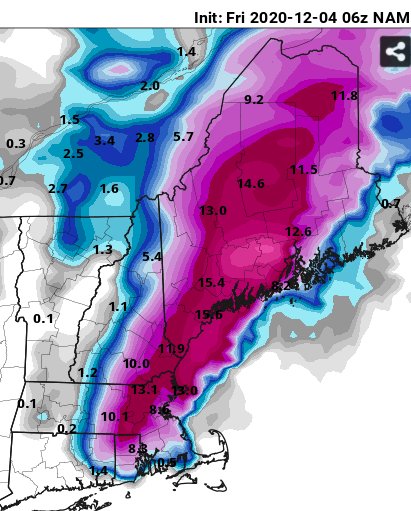
-
Dec 5/6th major coastal/ west Atlantic cyclogenesis ...?
wxsniss replied to Typhoon Tip's topic in New England
Someone asked about HRPDS... Doesn't carry much weight this far out, but 0z actually very close to 0z Euro... big hit for much of interior central-eastern SNE / southeast NH / eastern ME -
Dec 5/6th major coastal/ west Atlantic cyclogenesis ...?
wxsniss replied to Typhoon Tip's topic in New England
Given how steady Euro has been last 3 runs, I'd say NAM not latching on to anything other than noise Assuming dynamics can overcome 2m temps, which I think they would as depicted on Euro, getting more confident for 3-6" in Boston area Obviously still some fluctuations we'll see in the next 12 hours and will wait until 12z suite tomorrow for final calls -
Dec 5/6th major coastal/ west Atlantic cyclogenesis ...?
wxsniss replied to Typhoon Tip's topic in New England
Euro more or less held steady 12z and 0z runs -
Dec 5/6th major coastal/ west Atlantic cyclogenesis ...?
wxsniss replied to Typhoon Tip's topic in New England
Through 36, no drastic changes vs 12z, maybe a tic east but very close -
Dec 5/6th major coastal/ west Atlantic cyclogenesis ...?
wxsniss replied to Typhoon Tip's topic in New England
Huge hit on 0z GFS, NW of 18z With 0z RGEM and ICON also NW, 0z NAM is now looking like the anomaly -
Dec 5/6th major coastal/ west Atlantic cyclogenesis ...?
wxsniss replied to Typhoon Tip's topic in New England
Yeah I'm looking at soundings on Pivotal... for example between 495 to ORH... 850 and 925 are plenty cold where it's showing heavy rain... I'd expect the 2m temps 35-37F (if those are even correct) should be overcome with the intense rates it's showing -
Dec 5/6th major coastal/ west Atlantic cyclogenesis ...?
wxsniss replied to Typhoon Tip's topic in New England
Verbatim 0z RGEM thermals are suspect... has heavy rains to at least ORH -
Dec 5/6th major coastal/ west Atlantic cyclogenesis ...?
wxsniss replied to Typhoon Tip's topic in New England
0z RGEM made a decent jump NW thru 42-48h Not weighing it significantly until within 36h, but it's bucking the 0z trend so far -
Dec 5/6th major coastal/ west Atlantic cyclogenesis ...?
wxsniss replied to Typhoon Tip's topic in New England
An improvement over 18z with better stream interaction earlier... but at 12z Saturday, H5 overall remains a little more open when on today's 12z NAM it was already tilting... keeps things a little more progressive Wouldn't make any definite trend conclusions before 0z tonight -
Dec 5/6th major coastal/ west Atlantic cyclogenesis ...?
wxsniss replied to Typhoon Tip's topic in New England
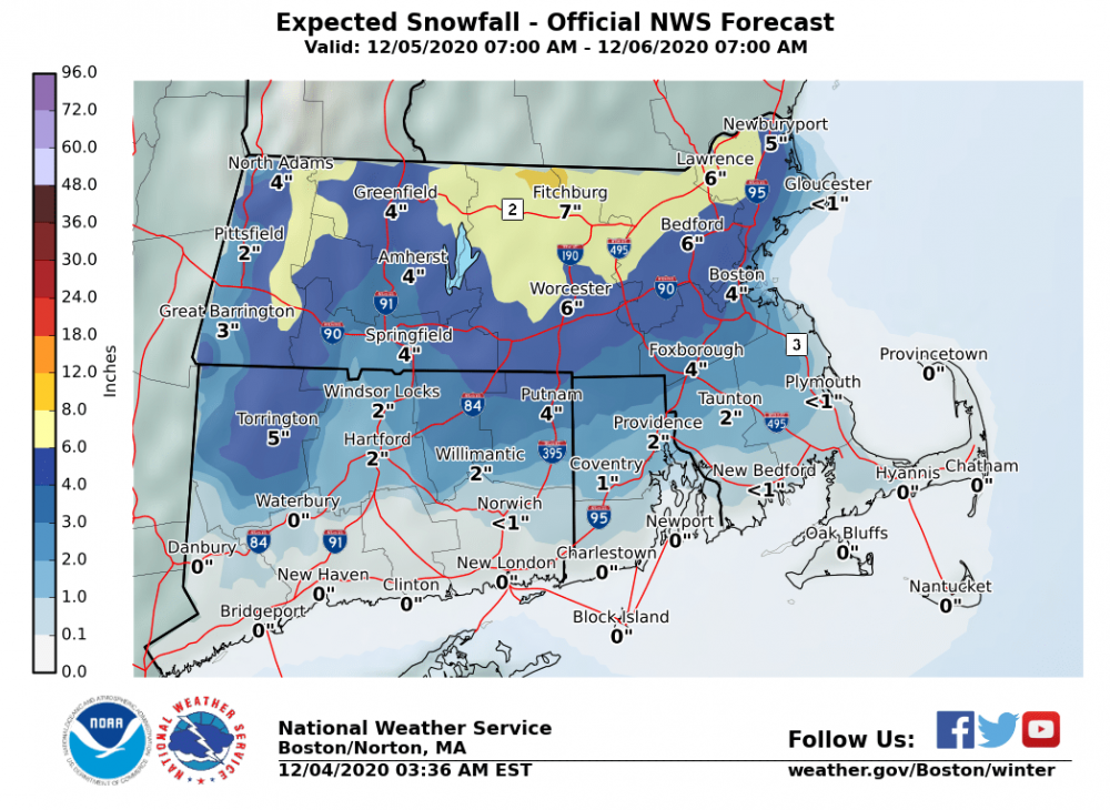
Box AFD (Nash) with quite the self-deprecating, open voice... and a message to hobbyists to boot... some excerpts: Models: still quite a bit of variation and the models are struggling with exactly how a northern stream disturbance currently diving south along the Ontario/Manitoba border and southern stream energy across the ArkLaTex region will merge later tomorrow... A 50 mile difference in track, or 6 hour timing difference in development means all the difference. What I`m trying to say here is make sure you have big error bars around the forecast. This is a great situation where probabilistic forecasts are much better than a single deterministic one. But since I`ve got to make a deterministic forecast, we`ll just have to work with it. Scenario:... NAM is believed to be a little too far east. More or less went with a 12z Canadian/ECMWF concept... Snowfall: ...I went with about 7-8:1 ratios during the day Saturday. As we get into the evening, rising to 9-11:1. For those playing at home and viewing snowfall predictions from online weather models, please be aware that most use a strict 10:1 ratio which will get you into trouble more often than not. Although I`m going with the lower snow ratios, there is an unknown if we end up getting a mesoscale band or well developed comma head forming. If that were to happen, that means we`ve got strong vertical motion in the snow growth zone resulting in large dendrites and a much higher SLR. After putting everything in a blender, I came out with amounts over 6" across higher elevations of MA with 2-4" widespread at lower elevations. Perhaps an 1" as you get just inland of the coast. Chances of my forecast being perfect? Pretty low. Snowfall amount probabilities suggest the potential for 10"+ across the higher terrain. Later forecasts will hopefully fine tune things. -
Dec 5/6th major coastal/ west Atlantic cyclogenesis ...?
wxsniss replied to Typhoon Tip's topic in New England
Model trends in past 24 hrs have attained dynamics of the Euro + more eastern track of GFS... threading the needle for eastern SNE