wxsniss
-
Posts
5,796 -
Joined
-
Last visited
Content Type
Profiles
Blogs
Forums
American Weather
Media Demo
Store
Gallery
Everything posted by wxsniss
-
-
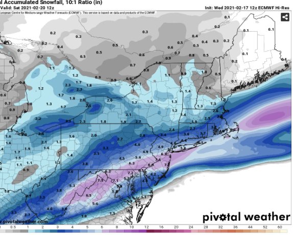
Wow 6z NAM captures a tick even further east eSNE crushed with a CCB Friday afternoon Would be widespread warning to coast
-
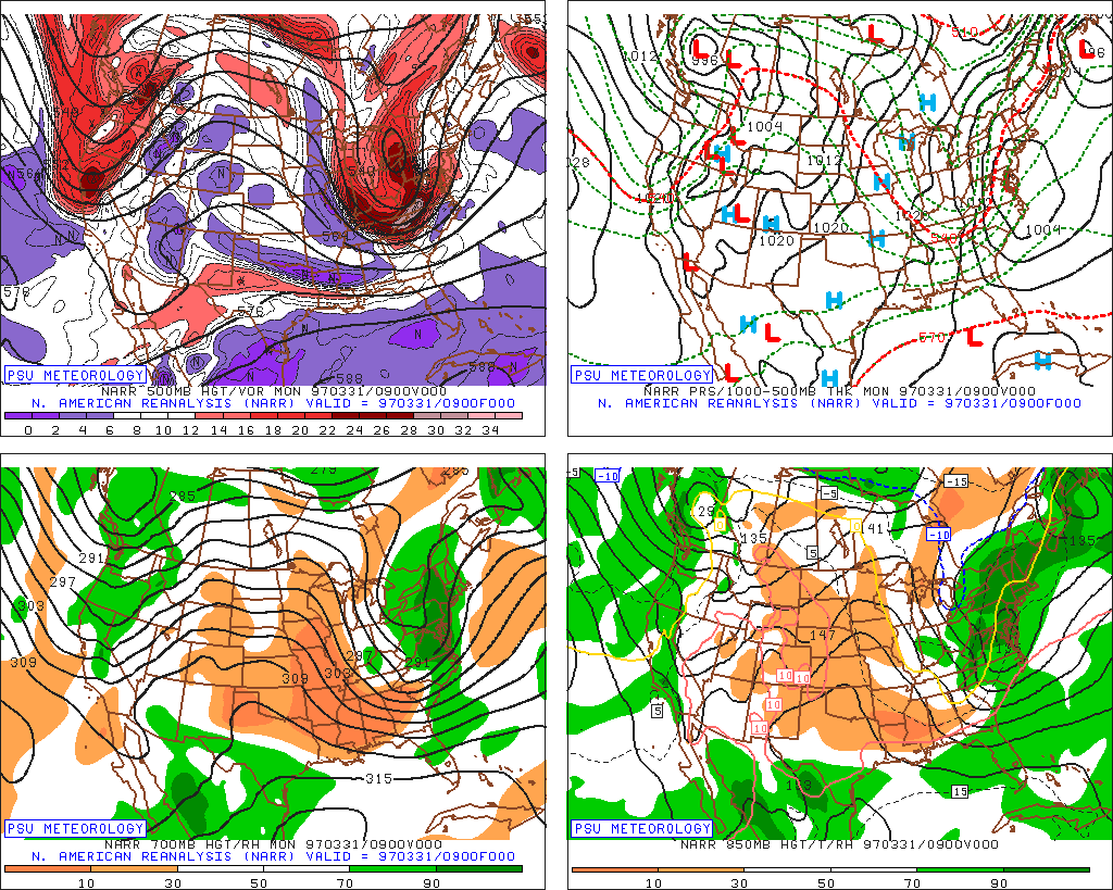
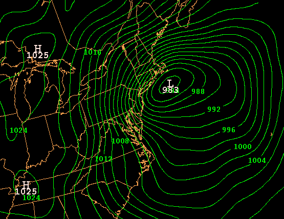
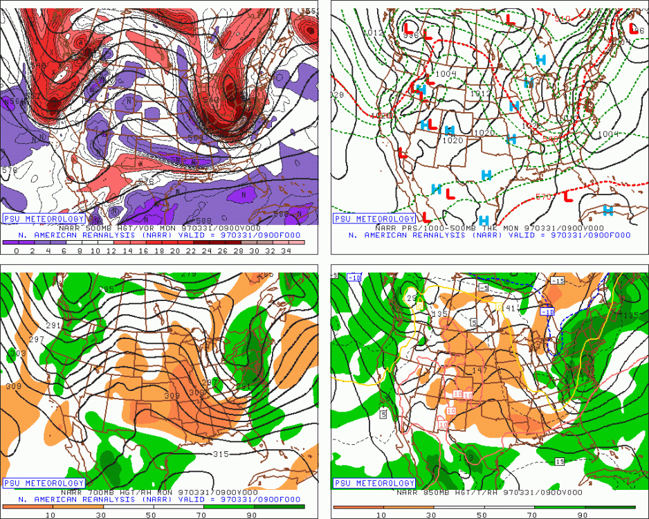
Was gonna say, don't even go there...! That there is hallowed ground haha Definite resemblance with some features, but 1997 had significantly sharper digging trough, surface deepening, longer duration... 3/31 9z: 4/1: H5: H8: Sfc:
-
Holy cow just looked at 0z 12k/3k's... like Gronk coming out of season retirement for one more spike. That would even at least whiten Boston metro area. NAM has been pretty consistent with digging that shortwave decently southeast of others
-
Thoughts on the NFT craze? TKAT and now HOFV and DLPN took off... don't know much about it, not sure if this is just another meme fad or a future in cyrptovaluation of digital art and other items. NYTimes had a feature on it this week.
-
With a last gasp effort, winter 20-21 refuses to give up the ghost
wxsniss replied to moneypitmike's topic in New England
Tip nailed this. What we had is weak cyclonic mechanics devolving even more into an anafrontal deal. Yesterday and before, guidance maintained better cyclonic mechanics as the system departed 6z-12z Friday. Now it’s almost a frontal passage. Not an issue of too warm or track too south. Remains solid C winter for Boston metro. Would’ve been worse (Jan 31 robbed 10”+ by 1-2F BL temps), but: - October snow is always magic - Dec 17 1-2am one of the most intense WAA snows we’ve seen in a long time - Brady Super Bowl snow -
With a last gasp effort, winter 20-21 refuses to give up the ghost
wxsniss replied to moneypitmike's topic in New England
Thanks that's what I figured, just checking if I was missing something. Looking at 850 wind barbs, how cyclonic vs. just parallel to the frontal boundary. And relatedly, how bent back vs. flat are the temp contours. At least on 0z Euro and 12z NAM, the cyclonic character looks best at 6z-9z and then starts to squash out by 12z. -
With a last gasp effort, winter 20-21 refuses to give up the ghost
wxsniss replied to moneypitmike's topic in New England
Tip or anyone... I know there's a continuum... at what levels do you assess degree of cyclonic mechanics within an anafrontal setup? This particular system seems like a good case to appreciate this. -
With a last gasp effort, winter 20-21 refuses to give up the ghost
wxsniss replied to moneypitmike's topic in New England
Wow 0z NAM coming in even more amped than 18z A tick further north Verbatim widespread warning SNE into southern VT/NH -
I think we're in a good spot. Current NWS map will be too conservative if cold advection is as quick as 12z/18z NAM and 12z Euro depict. Also great timing, it's all overnight so no sun issues. This late game critter could bump up this winter C to C+ for Boston metro
-
Back in January, 12-36 hours after Moderna #2: fever to 101.5 peaked at 24 hours, could barely leave bed or eat. Caught me by surprise, and many others reported similar. That RNA works! As I'm sure you've heard, radiologists are also incidentally seeing enlarged lymph nodes especially in vicinity of the shot, and even recommend deferring elective / screening imaging because it can raise false alarms of malignancy.
-
https://www.forbes.com/sites/georgecalhoun/2021/03/10/gamestop-the-second-surgeanatomy-of-a-gamma-swarm/
-
That lunch time torpedo today failed to shake people off, yet earned an SSR. Thursday should continue to be a wild ride. https://investorplace.com/2021/03/short-sale-restrictions-ssr-stocks-rule-alternative-uptick-gme-stock-wallstreetbets-reddit/
-
"What is this... a dip for ants?" Halted several times since 12:15, and now again on its way back up. Pretty amazing to watch this unfold. The institutional manipulation just motivates the little people more.
-
Blatant manipulation by large institutions.... millions of shares dumped all at once, looks like during or just after the halt. That's not retail.
-
GME trading halted again. Was knocking on 350. Seems like blatant manipulation, this will only bolster principled stands more.
-
Your call on DNN a few weeks back was spot on
-
What was the trigger today? Wary of falling for the reddit financial flash mob again...
-
-
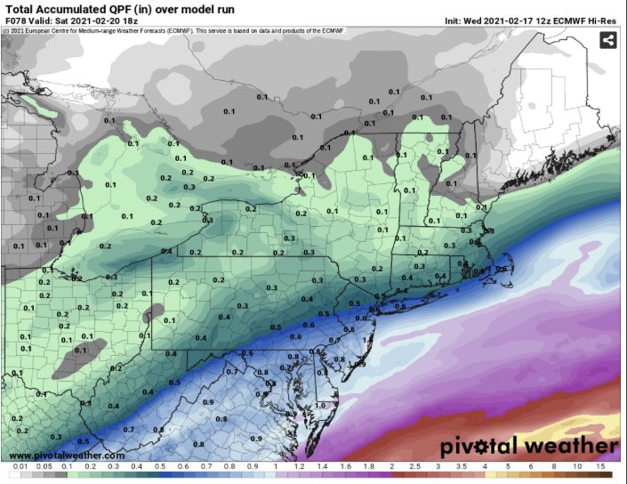
Euro struggled with 2nd portion of storm, even counting for higher ratios
-
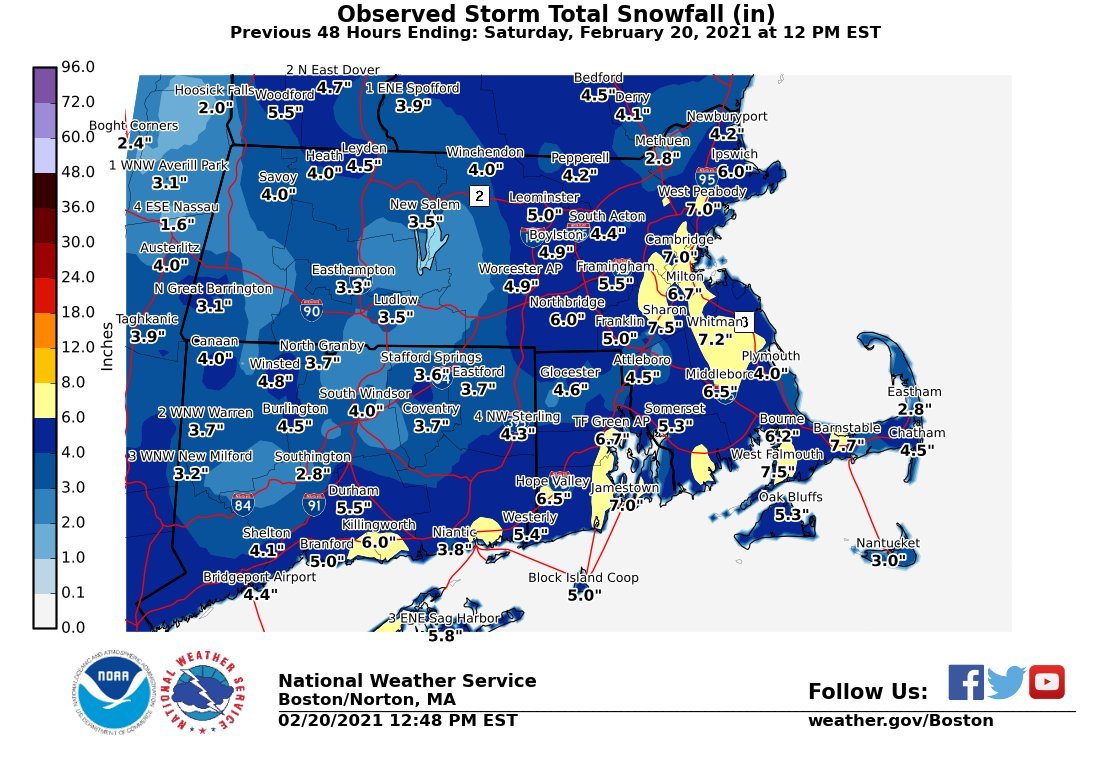
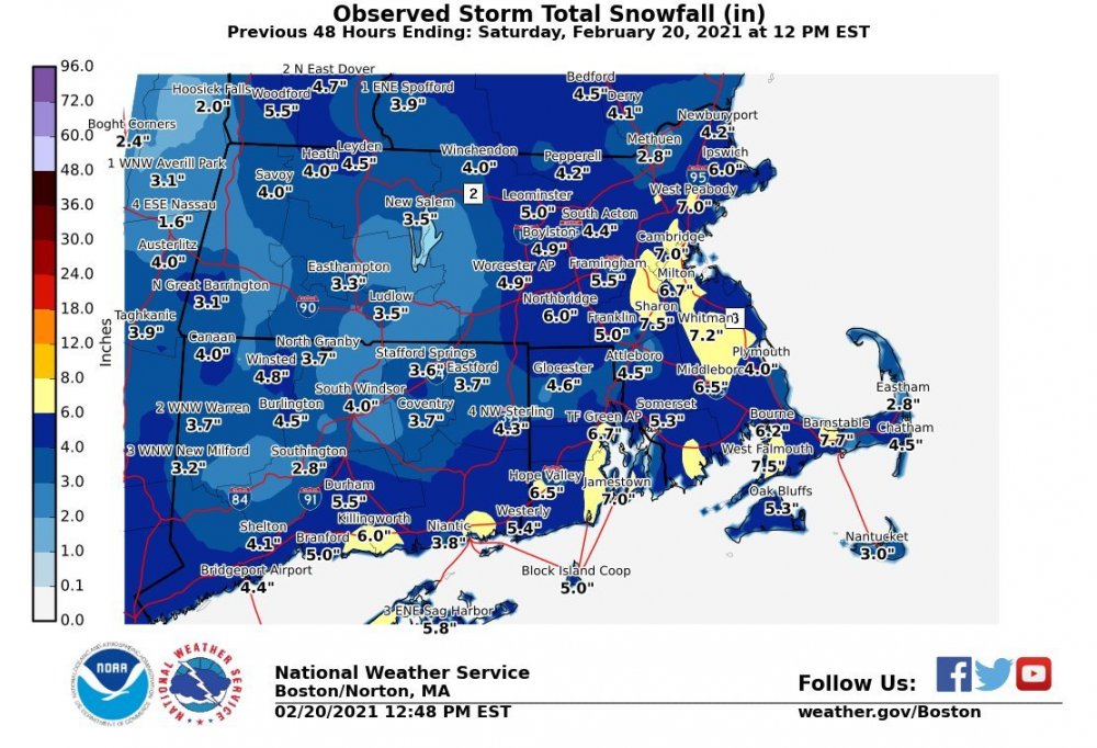
A subset of SNE totals... generally 4-7" ORH east: KBOS 5.7 / East Boston 6.5 / Charlestown 7.1 / Dorcester 7.0 As many expected, jack was Milton 7.3: ...Suffolk County... Charlestown 7.1 1127 PM 2/19 General Public Dorchester 7.0 1113 PM 2/19 Ham Radio West Roxbury 6.8 1031 PM 2/19 Ham Radio East Boston 6.5 1045 PM 2/19 General Public Roslindale 6.0 1010 PM 2/19 Public Logan AP 5.7 1215 AM 2/20 Airport Chelsea 5.6 1105 PM 2/19 Trained Spotter Allston 5.4 1140 PM 2/19 Broadcast Media ...Plymouth County... Whitman 7.2 1237 AM 2/20 Trained Spotter Rockland 6.0 1100 PM 2/19 Trained Spotter Middleboro 5.1 1158 PM 2/19 Ham Radio ...Norfolk County... Milton 7.3 1121 PM 2/19 Trained Spotter Westwood 7.0 1000 PM 2/19 Public Weymouth 6.6 1144 PM 2/19 Public 2 W Walpole 6.0 1218 AM 2/20 Public Walpole 5.5 1000 PM 2/19 NWS Employee Sharon 5.5 827 PM 2/19 Trained Spotter Randolph 5.3 1030 PM 2/19 Trained Spotter Millis 5.0 1002 PM 2/19 Trained Spotter Foxboro 5.0 1133 PM 2/19 NWS Employee ...Worcester County... Northbridge 6.0 1053 PM 2/19 General Public Fitchburg 5.1 920 PM 2/19 Co-Op Observer Lunenburg 5.1 918 PM 2/19 Trained Spotter Worcester 4.9 1028 PM 2/19 CWO Worcester AP 4.9 1216 AM 2/20 Airport ...Barnstable County... Marstons Mills 4.7 1244 AM 2/20 Ham Radio west harwich 3.8 416 PM 2/19 Ham Radio Barnstable 3.6 855 PM 2/19 NWS Employee ...Essex County... Topsfield 6.0 952 PM 2/19 Public Peabody 5.5 830 PM 2/19 Public Swampscott 5.0 1000 PM 2/19 Public Ipswich 5.0 951 PM 2/19 Trained Spotter ...Middlesex County... Wilmington 6.5 1151 PM 2/19 Public West Newton 6.2 1107 PM 2/19 General Public Framingham 5.5 1027 PM 2/19 General Public CONNECTICUT ...Hartford County... Burlington 4.5 802 PM 2/19 Trained Spotter Collinsville 4.0 853 PM 2/19 General Public South Windsor 4.0 1112 PM 2/19 Trained Spotter North Granby 3.7 756 PM 2/19 Trained Spotter West Hartford 3.5 853 PM 2/19 Broadcast Media RHODE ISLAND ...Kent County... TF Green AP 6.7 1215 AM 2/20 Airport ...Providence County... East Providence 4.5 1000 PM 2/19 Public Providence 3.0 1100 PM 2/19 Public
-
Hard to see how KBOS is not over 6" given 4.5" at 7pm and best returns of the event 8-10pm... What a fun event. Not a blockbuster, but still had its own charm. Guidance was actually pretty decent... we were guarded after Tuesday's debacle but guidance actually verified pretty well. The other thing that threw people off: Euro was simply not good on this. Not a good winter in general for it. Robust solutions on GFS / UK / RGEM proved correct in handling the reinvigorated low Thurs-Fri. Just looking at 12z Wednesday guidance... best guidance: NAM, RGEM, GFS, UK GFS father > v16, though too robust in northeast MA up into southeast NH/ME
-
HRRR and RAP nailed it Best steady rates of the event underway now in Boston metro and will probably continue through 10pm Very likely KBOS breaks 6" from 4.5" at 7pm
-
23z HRRR has flakes in the air at least until midnight for BOS Verbatim another 2-3" for Boston metro, highest south shore with spots 4" Best rates for Boston metro between 7-10pm and radar supports that
-
Isn't it the opposite...? I could be wrong but I thought it was upper level clouds seeding and enhancing lower level OES cells? I had posted this last night: