wxsniss
-
Posts
5,520 -
Joined
-
Last visited
Content Type
Profiles
Blogs
Forums
American Weather
Media Demo
Store
Gallery
Everything posted by wxsniss
-
Active mid December with multiple event potential
wxsniss replied to Typhoon Tip's topic in New England
The issue we were talking about yesterday... that next-in-line shortwave digging more is interfering and de-amplifying our trough You can see it's less an issue on the 12z NAM -
Active mid December with multiple event potential
wxsniss replied to Typhoon Tip's topic in New England
Yep... while ptype and dryslot issues starting to creep into southeast MA Great banding signature to MA/NH border Ukie and NAM now more alike than Euro -
Active mid December with multiple event potential
wxsniss replied to Typhoon Tip's topic in New England
Yeah this is not done trending... 6z NAM looks even more amped and further NW than 0z -
Active mid December with multiple event potential
wxsniss replied to Typhoon Tip's topic in New England
Yeah you might guess the shortwave got shredded on approach if you just looked at the QPF maps, but it's definitely better than 12z -
Active mid December with multiple event potential
wxsniss replied to Typhoon Tip's topic in New England
This is a much better solution than 12z for SNE than the QPF maps would suggest -
Active mid December with multiple event potential
wxsniss replied to Typhoon Tip's topic in New England
H5 closed already at hr 54... this is a big jump NW -
Active mid December with multiple event potential
wxsniss replied to Typhoon Tip's topic in New England
Thru 48 already looking better Better looking shortwave Downstream ridging is better Better spacing from upstream shortwave This will be tucked more NW -
Active mid December with multiple event potential
wxsniss replied to Typhoon Tip's topic in New England
Thru 36h better digging trough and downstream ridging Watching the following energy over Saskatchewan... it's digging a little more than 18z, may not make any difference but we want that to remain flat and inconsequential... that's the piece that muffed a better SNE hit on today's12z Euro -
Active mid December with multiple event potential
wxsniss replied to Typhoon Tip's topic in New England
Huge hit well into NH and VT -
Active mid December with multiple event potential
wxsniss replied to Typhoon Tip's topic in New England
Crazy weekend at work but lurking... 0z NAM way further west and the H5 changes were apparent as early as 24 hours... significantly more amped than 18z NAM and Euro Whether this represents new sampling off Pacific vs. NAM in laughable range remains TBD... maybe only takehome point is further lack of support for GFS -
December 5-6, 2020 Storm Observations and Nowcast
wxsniss replied to Baroclinic Zone's topic in New England
Yeah I see it now, thanks all, it really was that simple. The changeover had transiently good lift through the DGZ, I guess enough to cool soundings to keep it snow thereafter. But lift dropped and stayed low while we were supposed to be rocking in a comma head. These are from 12z 3k NAM, before (21z), ~during (00z, I know in reality changeover was around 21z), and after (02z):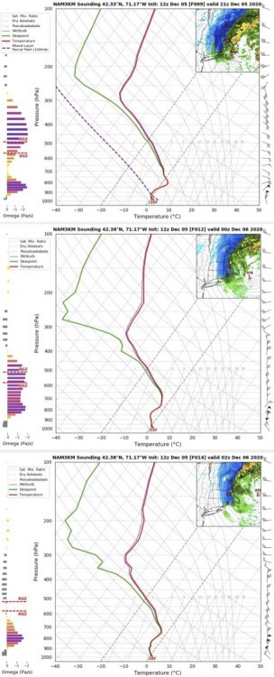
-
December 5-6, 2020 Storm Observations and Nowcast
wxsniss replied to Baroclinic Zone's topic in New England
Thanks man! Great disco here between you, Will, Tip, OceanStWx, and others... One question that's been bugging me because I'm sure the answer is simple: All the red flags granted --- lift way lower than DGZ, DGZ so high up that there's a longer 32F path of descent and the "snow" is more ready to melt, lack of drier dewpoints, garbage airmass --- but none of these were an issue during the changeover. I made a timelapse (I can't figure out how to upload) showing we went from rain bare ground to white coating on most surfaces in < 5 min! And people everywhere metrowest down to northeast CT were reporting the same. At 4pm, extrapolating that for the next 4+ hours, even if intermittent, it looked like much of eSNE would easily reach the NWS totals as the bands pivoted. Anyone know why was that 30 min period during the changeover able to overcome all the red flags, in contrast to the subsequent 4+ hours? -
December 5-6, 2020 Storm Observations and Nowcast
wxsniss replied to Baroclinic Zone's topic in New England
Boy, 7 months old Thanks for the nice words, Jerry. Yes, it's more exhausting and more magical than I had ever imagined. I've already had my first instance of getting all ready at 12:50am to geek out over another most important Euro run of our lives, only to be drawn away because he wakes up crying. Maybe he didn't like the solution October snow was his first! -
December 5-6, 2020 Storm Observations and Nowcast
wxsniss replied to Baroclinic Zone's topic in New England
Thank you for that. That is so refreshing. Only the best here, including you, Walt, and some others, are confident enough to admit when they were wrong and understand why. Attributing incorrect forecasts to weenie maps across the board is a tiresome narrative. Career NWS mets, actually putting up concrete maps, and to an audience of hundreds of thousands, got this and other storms wrong, and it's not because they were rip-reading weatherbell maps. There were plenty of red flags that we can point to in hindisight. As always, a confluence explains the bust. Last night we actually mentioned that the best omega was well below the DGZ in eastern SNE throughout most of the event --- but maybe we dismissed that as generating poor but not inadequate snowgrowth. We've certainly overcome that in other storms. A stinger never really materialized. We've certainly had past storms overcome marginal airmasses with good dynamics, and maybe this just did not pack enough punch. Not a single person here would have said Northborough would end up with 1.5". Even Lunenberg managed only 6.5" lol. -
December 5-6, 2020 Storm Observations and Nowcast
wxsniss replied to Baroclinic Zone's topic in New England
Thanks Jerry I’ll find out soon enough if love of weather is inherited or learned -
December 5-6, 2020 Storm Observations and Nowcast
wxsniss replied to Baroclinic Zone's topic in New England
Looking back... GFS actually looks like it may have had the most accurate progs. Check out 0z run 12/5 was very close to reality. NAM / Euro under-weighed the low level warmth, and also were too dynamic... including runs yesterday and 0z 12/5 right up to gametime. RGEM atrocious, furnace and was still more wrong than the rest. -
December 5-6, 2020 Storm Observations and Nowcast
wxsniss replied to Baroclinic Zone's topic in New England
That's exactly why I raised the thundersnow example... has nothing to do with garbage airmass or weenie 10:1 maps. We had several instability profiles posted yesterday, talk of CSI, multiple Mets and AFDs that mentioned the possibility if not likelihood of thunder over central MA. It's just one objective measure that did not pan out. Not at all a complaint, and nothing you or anyone here can control, maybe unless you're a plow driver NWS forecasts will bust too high for large portions of SNE, but this was a fun early season storm in the books. -
December 5-6, 2020 Storm Observations and Nowcast
wxsniss replied to Baroclinic Zone's topic in New England
Fun storm, but no way my 3-6 (or NWS 4-8) for Boston area verifies seeing as we are in the CCB now and it’s underwhelming. I get the disappointment. Take aside the well anticipated poor snow growth and melting, it still overall seems less dynamic than most guidance progged. Even for ORH hills and north, seems it underperformed. Did we even have a single report of thundersnow anywhere? -
December 5-6, 2020 Storm Observations and Nowcast
wxsniss replied to Baroclinic Zone's topic in New England
Yeah winds gusting out of NW more than N already... can see low center on radar almost at KBOS latitude 21z HRRR still strong through 8pm or so for metrowest... obviously best will be north shore As expected, the crappy ratios 5:1-7:1 and melting aren't helping sensible accums -
December 5-6, 2020 Storm Observations and Nowcast
wxsniss replied to Baroclinic Zone's topic in New England
Did your old neighborhood (currently mby) have underground power lines? And your current neighborhood? I understand underground lines significantly minimize risks of weather outages, but they're expensive to maintain and repair. We lost power for ~ 8 hours last night... not fun, especially with an infant. -
December 5-6, 2020 Storm Observations and Nowcast
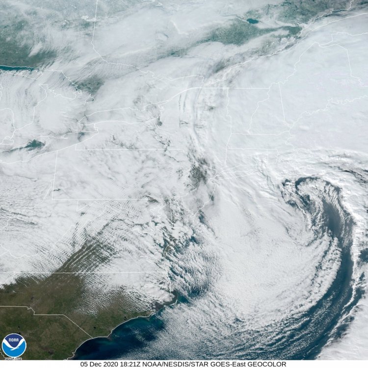
wxsniss replied to Baroclinic Zone's topic in New England
-
December 5-6, 2020 Storm Observations and Nowcast
wxsniss replied to Baroclinic Zone's topic in New England
Went from rain to heavy snow in about 120 seconds -
December 5-6, 2020 Storm Observations and Nowcast
wxsniss replied to Baroclinic Zone's topic in New England
First flakes Brookline Village 3:50pm -
December 5-6, 2020 Storm Observations and Nowcast
wxsniss replied to Baroclinic Zone's topic in New England
Brookline (lower elevation than Jerry)... you can hear it, still can’t see it -
December 5-6, 2020 Storm Observations and Nowcast
wxsniss replied to Baroclinic Zone's topic in New England
Before sun sets: