

wxsniss
-
Posts
5,520 -
Joined
-
Last visited
Content Type
Profiles
Blogs
Forums
American Weather
Media Demo
Store
Gallery
Everything posted by wxsniss
-
Significant upper middle Atlantic S/CNE mix/snow potential Jan 3+
wxsniss replied to Typhoon Tip's topic in New England
And also how difficult it is to prognosticate based on upstream features... Usually we can make predictions "this run will be better/worse based on x"... I haven't followed as closely, but this event is so dependent on tiny nuances of position and timing of a capture, and it's more difficult to pick up trends and key determinants. You could see 0z Nam would be further southeast with best baroclinicity farther out, but it still captures and loops back to hit ME. -
Merry Christmas and happy holidays all! Good riddance to 2020, and here's to having a place where, year after year, ratters or epicosity, we can escape in love of weather.
-
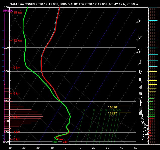
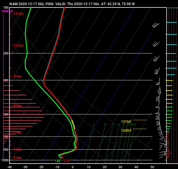
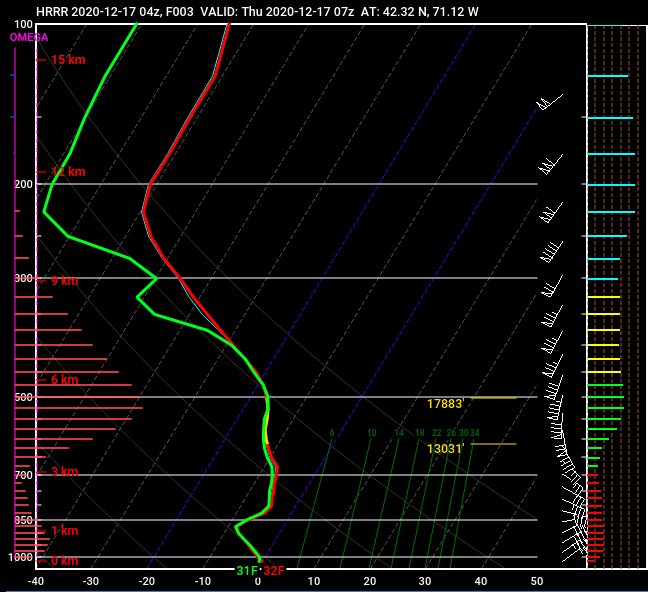
I pulled up soundings for that exact location and model... DGZ = 16091 - 2415 = 13676 feet !!! Someone at Okemo could sneeze up and it would snow. But still puzzled by soundings at Binghamton (I posted above)... DGZ throughout the event on multiple models was only ~ 3000 feet... not particularly deep. Either model soundings were not accurate (e.g., H85-H7 temps were much colder than progged), or combination of extreme lift + great ratios was enough.
-
0z Euro Thurs (event already underway) had a decent Kuchera map... QPF in the fronto band ranged from 1-1.7, so with ratios up to 20:1, you might see how you could get to 40": (note... no Euro run before this had anything close to reality... models massively missed a historic weather event for PA-NY-VT-NH):
-
Yeah it's a puzzle... looking back at soundings from Thurs 0z 3k NAM / 12k NAM (can't see HRRR that far back): 6z Thursday night, under the heaviest band near Binghamton... insane lift, but not an especially deep DGZ:
-
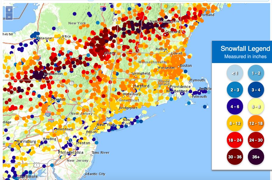
https://www.weather.gov/source/crh/snowmap.html
-
What an awesome storm... that WCB band through eastern MA 1-2am was one of the best I've seen in 25+ years in Boston Multiple different mechanisms on display (WCB, mid-level frontogenesis, CCB) more geographically disjointed than what I'm used to seeing This season already a great start with 2 over-performers (Oct 29, Dec 16), 1 big bust (Dec 5) Still don't understand why not a single model had any clue on that mid-level fronto being so far northwest, intense, and stationary... do we know if the track of the ULL was very different than progged? Haven't had time to go through guidance vs. mesoanalysis to understand what happened.
-
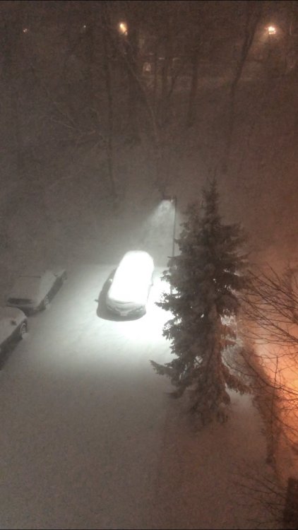
Yeah Jay 1-2am was one of the most intense WCBs I’ve ever seen in the Boston area Visibility down to a few hundred yards, rates of 2-4” / hr I’m failing to upload a movie clip in the max space allowed, and YouTube resolution is bad This photo does no justice... a fog of heavy snow, big flakes:
-
It's crawling... so far not the same visibility and snowgrowth that we had 1:30am... wonder what obs are south of the city where returns are better
-
NWS twitter confirms we were getting 2-3"/hr in that first band, not surprised at all https://twitter.com/NWSBoston/status/1339462076847144962?s=20 7z HRRR soundings continue great for next 2-3 hours
-
Next mega band approaching Boston area... wonder if Jerry wakes up to see it 12:30-2am was incredible, heaviest rates we've had in years, several hundred yard visibility for hours
-
Seriously wondering about approaching blizzard criteria... hours of < 1/4 visibility, already occasional gusts > 35 at KBOS...
-
0z Euro agrees, no major changes Surpassing my expectations Visibility easily < 1/4, and this has been going on for > 1 hour so far... I'm wondering how close we will be to blizzard criteria... seems like only winds might fall short, but they will pick up through the night, already gusts to 37 at KBOS
-
Wow this is really, really impressive... Can't wait to see Jerry's reaction when he wakes up Must be years since we've had these steady heavy rates in Boston metro Easily < 1/4m visibility
-
Ground truth is really delivering, wow... And look what Boston metro area and much of eastern SNE has to look forward to later tonight:
-
upstream returns looking really healthy for eastern MA 1-5 am should deliver some good stuff:
-
0z HREF looks great for most:
-
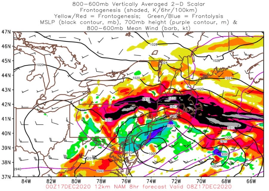
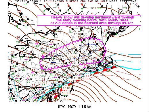
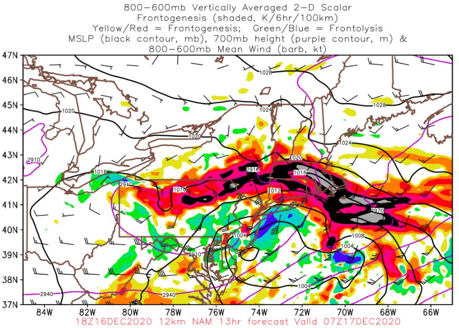
Mesoscale Discussion 1856 NWS Storm Prediction Center Norman OK 0912 PM CST Wed Dec 16 2020 Areas affected...Extreme northeastern PA...parts of southern/eastern NY...northern CT...western and northern MA...southern NH/VT Concerning...Heavy snow Valid 170312Z - 170915Z SUMMARY...The primary band of persistent heavy snow will orient from southern/east central NY across northwestern MA to southern VT/NH through the early morning hours, with 2-3 inch per hour rates expected through 09-12z. DISCUSSION...A 1002 mb surface cyclone along the MD coast will continue northeastward through early Thursday morning, just off the southern New England coast. Very strong low-midlevel warm advection has contributed to heavy snowfall the past several hours across parts of PA/NY into southern New England. A warm nose in the 850-700 mb layer (temperatures near or just above 0 C), and ocean influences near the coast have resulted in mixed precipitation spreading northward across NJ and Long Island, and this trend will continue into coastal areas of southern New England overnight. Additionally, the midlevel dry slot has reduced saturation in the dendritic growth zone (generally 600-500 mb layer) from south to north, which has reduced snowfall intensity and also contributed to mixed precipitation types. Northwest of the dry slot, the longer-duration heavy snow is expected, with some banding structures and embedded convection in association with weak static stability and focused frontogenesis in the midlevels. Here, ascent will be maximized in the dendritic growth zone for several hours and temperature profiles will remain well below 0 C, which will support snowfall rates of 2-3 inches per hour through about sunrise.
-
First flakes Brookline!
-
Yeah this will actually take a bit of strategy lol... For our area, I'm thinking best rates from WCB portion will be 1-5am... also will be fun to nowcast the CF flirting with the Boston metro for several hours, should see some enhancement north of that
-
2am-7am will be a blast for much of SNE...
-
Active mid December with multiple event potential
wxsniss replied to Typhoon Tip's topic in New England
Upstream obs... Philly area was getting 40-50+ dBZ, heavy snow WAA thump will rock tonight... might take some creative sleep strategies to be up for the best of it -
Active mid December with multiple event potential
wxsniss replied to Typhoon Tip's topic in New England
-
Active mid December with multiple event potential
wxsniss replied to Typhoon Tip's topic in New England
6z HRRR steady as she goes, slightly more robust than 0z HRRR... 6z NAM same Widespread 10-16" most of SNE, spots higher CF gets to just barely past Boston -
Active mid December with multiple event potential
wxsniss replied to Typhoon Tip's topic in New England
Better for much of SNE More uniform... maybe better warm conveyor belt into MA, less robbing from that convective blob, and as a result more uniform spread between the WAA and midlevel banding


