

wxsniss
-
Posts
5,520 -
Joined
-
Last visited
Content Type
Profiles
Blogs
Forums
American Weather
Media Demo
Store
Gallery
Everything posted by wxsniss
-
Watching closely .. February 1-3rd for moderate to major coastal event
wxsniss replied to Typhoon Tip's topic in New England
18z NAM 10:1, through 48 hrs, 18z Tues... best one yet for much of SNE: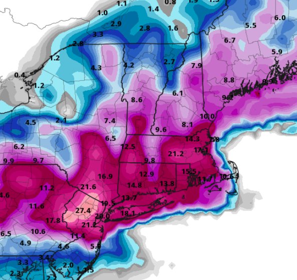
-
Watching closely .. February 1-3rd for moderate to major coastal event
wxsniss replied to Typhoon Tip's topic in New England
Best run yet for just about all of SNE One of the most steady NAM performances I can remember... other guidance has wavered alot more As noted earlier, this is almost dead on with the HREF -
Watching closely .. February 1-3rd for moderate to major coastal event
wxsniss replied to Typhoon Tip's topic in New England
NAM has been incredibly steady since Saturday crushing for much of SNE at hr 30, including eastern MA -
Watching closely .. February 1-3rd for moderate to major coastal event
wxsniss replied to Typhoon Tip's topic in New England
18z NAM holding strong, if not a tick east thru Crushing firehouse for southern SNE, CT into NYC area at hr 27 -
Watching closely .. February 1-3rd for moderate to major coastal event
wxsniss replied to Typhoon Tip's topic in New England
Compared to 0z run, definitely ticked colder in eastern SNE at 850 and 925... but the WAA thump was not as robust as 0z, and mechanics are still a little disjointed... so not as robust a solution as NAM -
Watching closely .. February 1-3rd for moderate to major coastal event
wxsniss replied to Typhoon Tip's topic in New England
Thru hr 30, H7 low definitely ticked northeast -
Watching closely .. February 1-3rd for moderate to major coastal event
wxsniss replied to Typhoon Tip's topic in New England
Yeah I wouldn't take verbatim just yet, but it is very consistent with NAM which has been surprisingly steady for 6+ cycles now, and other guidance has ticked colder for eastern SNE... -
Watching closely .. February 1-3rd for moderate to major coastal event
wxsniss replied to Typhoon Tip's topic in New England
Between work, baby, GME, haven’t posted as much as I’d like... This is looking great for SNE: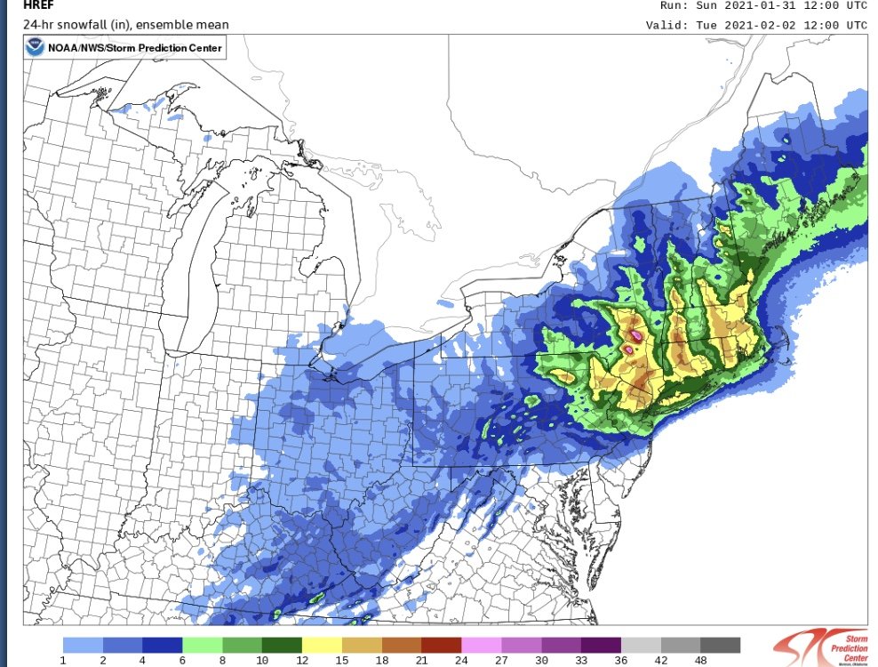
-
Watching closely .. February 1-3rd for moderate to major coastal event
wxsniss replied to Typhoon Tip's topic in New England
HREF supports NAM and HRRR: Thru Tues 0z only: -
Watching closely .. February 1-3rd for moderate to major coastal event
wxsniss replied to Typhoon Tip's topic in New England
From 12z Initial thump will deliver -
Watching closely .. February 1-3rd for moderate to major coastal event
wxsniss replied to Typhoon Tip's topic in New England
NAM is like [emoji184]🤲[emoji184]🤲[emoji184] Surprisingly may be the most steady guidance since Saturday Add CF enhancement to this: -
Watching closely .. February 1-3rd for moderate to major coastal event
wxsniss replied to Typhoon Tip's topic in New England
0z NAM 10:1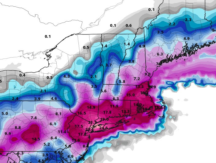
-
Watching closely .. February 1-3rd for moderate to major coastal event
wxsniss replied to Typhoon Tip's topic in New England
Hour 54... 6z 2/2... huge hit on eastern SNE... actually a tick colder than 18z Is it fair to say that strangely enough, NAM has been one of the more consistent models today? -
From Washington Post / Boston.com today... Not agreeing or disagreeing, and I know previously discussed here extensively... Simplistic explanation of recent SSW event, split PV, negative AO / NAO, possible implications for us: https://www.boston.com/uncategorized/weather/2021/01/05/the-polar-vortex-is-splitting-in-two-which-may-lead-to-weeks-of-wild-winter-weather
-
Significant upper middle Atlantic S/CNE mix/snow potential Jan 3+
wxsniss replied to Typhoon Tip's topic in New England
Cool to see the simultaneous OES echoes and storm echoes moving in opposite directions -
Significant upper middle Atlantic S/CNE mix/snow potential Jan 3+
wxsniss replied to Typhoon Tip's topic in New England
34F, decent wet flakes on this side of the CF. Actually quickly whitening cars under these 30 dBZs! To quote Jerry, "this is what it's come to?" -
Significant upper middle Atlantic S/CNE mix/snow potential Jan 3+
wxsniss replied to Typhoon Tip's topic in New England
Disparate pockets of moisture? -
Significant upper middle Atlantic S/CNE mix/snow potential Jan 3+
wxsniss replied to Typhoon Tip's topic in New England
It was always a precarious setup, but wow what a poor showing for Euro within 24 hours of start... Maybe you can fudge the advisory level solutions in SNE, but look how drastically it changed in Maine. -
Significant upper middle Atlantic S/CNE mix/snow potential Jan 3+
wxsniss replied to Typhoon Tip's topic in New England
I don't mind the map, as much as the fact that it somehow represents the primary forecast (vs. NWS) to the entire Boston.com audience, and also that he hates snow. I love it when he busts too low. -
Significant upper middle Atlantic S/CNE mix/snow potential Jan 3+
wxsniss replied to Typhoon Tip's topic in New England
Agree, same impression off 12z Euro This 18z was a big run... Euro has been on its own this afternoon -
Significant upper middle Atlantic S/CNE mix/snow potential Jan 3+
wxsniss replied to Typhoon Tip's topic in New England
Not so great on this particular run and disappoints the ME crowd, but the capture is probably still too sensitive and distant to pin down now -
Significant upper middle Atlantic S/CNE mix/snow potential Jan 3+
wxsniss replied to Typhoon Tip's topic in New England
Yeah great to see 18z Euro double down on its 12z run... Euro is kind of on its own here with the 3-6/4-8 amounts into eastern MA, but I weigh it more than the rest. -
Significant upper middle Atlantic S/CNE mix/snow potential Jan 3+
wxsniss replied to Typhoon Tip's topic in New England
Looking at all the 12z/18z guidance so far... Only the 12z Euro (and 18z HRRR, well out of range) and EPS support the higher 3-6/4-8 amounts in eastern SNE... if it were any other model going against the consensus, we'd toss it. Fair to weigh it more heavily at the moment, but it will need to double down at 18z / 0z. Otherwise the Box map is looking about right. -
Significant upper middle Atlantic S/CNE mix/snow potential Jan 3+
wxsniss replied to Typhoon Tip's topic in New England
Unfortunately just 1 run of the Euro... great trend, but guidance is still all over to be completely certain with this For eastern SNE, the crappy air mass also makes me hesitant of widespread 3-6/4-8" until we're more confident of the better dynamics -
Significant upper middle Atlantic S/CNE mix/snow potential Jan 3+
wxsniss replied to Typhoon Tip's topic in New England
For SNE, pretty sizable discontinuity on 12z Euro compared to 0z / yesterday's 12z... This 12z run finally has a more expected distribution of dynamics and QPF you'd expect with a SLP tracking over the benchmark. By 18z Mon, with an H5 low now closing completely off the Cape compared to over SNE in prior runs, might expect even more further NW of that into SNE and eventually eastern NH / eastern ME.


