wxsniss
-
Posts
5,520 -
Joined
-
Last visited
Content Type
Profiles
Blogs
Forums
American Weather
Media Demo
Store
Gallery
Everything posted by wxsniss
-
hr24 trough axis is better, less confluence ahead... this might actually tick west, for better/worse depending on where you are
-
Oh I know lol And I understand the nerves... my area / north metrowest may have similar issues And while I'm fairly confident, I'm not 100% absolutely certain we don't see progressively earlier capture until it's congrats Forky Sounds like a broken record, but once again Euro run will be critical
-
Yeah always great to see Harv fired up, classic. 0z NAM verbatim might have a chunk of 17-19" deep in his 24"+ zone, and would also warrant expanding the 18-24 zone farther west... he did neither. Appropriately not flinching to that single piece of guidance.
-
Harv didn't flinch with the 0z NAM 24+ all of eastern Mass
-
I'm with you, been watching that all day... odds are this 0z NAM is not the verbatim final outcome. I suspect either Euro holds or this tics even closer and we're into the meat of the CCB.
-
Same. Felt like I lost a lifelong friend when I heard. RIP, he's smiling down on NE tonight.
-
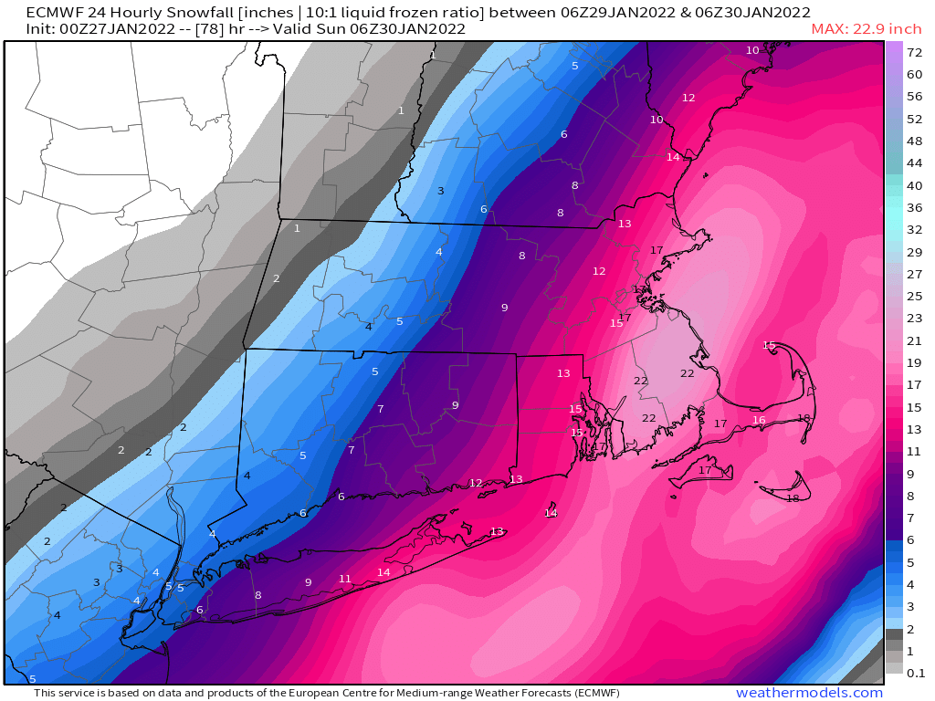
Yeah unreal That goes through Boston metro area and much of eastern MA 15z-21z Sat In case people missed it in the torrent of posts... check out these soundings from 18z NAM... easily 3-4"/hr... why the AFD is talking about "exceptional to extreme snowfall rates":
-
Not WDrag level, but still a keeper for archives, just an excerpt... and finally dropped the "B" word: In addition, we are increasingly concerned about blizzard or near- blizzard conditions developing. With 925mb winds at 75 kts, temperatures in the teens to low 20s, it is looking likely that blowing snow would result in significantly reduced or near-zero visibilities at times for southeastern MA. Right now, we are most confident in blizzard conditions developing from Plymouth county into Cape/Islands. It is not out of the question that the Providence to Boston corridor could come into play but we need to see further confirmation of the westward trend. The silver lining is that because we are dealing with dry powdery fluff, there is less of a concern for snow loading issues except for parts of the Outer Cape and Nantucket due to the coastal front. Do want to briefly touch on the potential for exceptional to extreme snowfall rates. Both NAM and GFS Bufkit soundings show 80-90 units of omega coinciding with the favorable snow growth region. Given that a double barrel low could develop with the potential for an eye- like feature at some point, wherever the mesoscale snow band sets up could see 3 to even 4 inches per hour snowfall rates. With this forecast package, we have capped the totals at 24 inches. But if we get more confidence (especially if the GFS comes further west in line with the international guidance), the forecast amounts for southeastern MA could go up into the 30 to 36 inches range. And with the winds gusting over 50 to 60 mph and temps well below freezing, stay off the roads on Saturday if possible.
-
Fwiw which is probably just adding noise but confirming the sensitivity of the synoptics: 18z RGEM showing that dual-low BS with a runaway low farther northeast, not as good a hit as 12z
-
Have not seen the "B" word in their AFDs... maybe some of the mesos are giving pause, but you'd think we are close with the Euro/NAM doubling down
-
hr54 956 off elbow this is a better run than 12z and spreads wealth farther NW
-
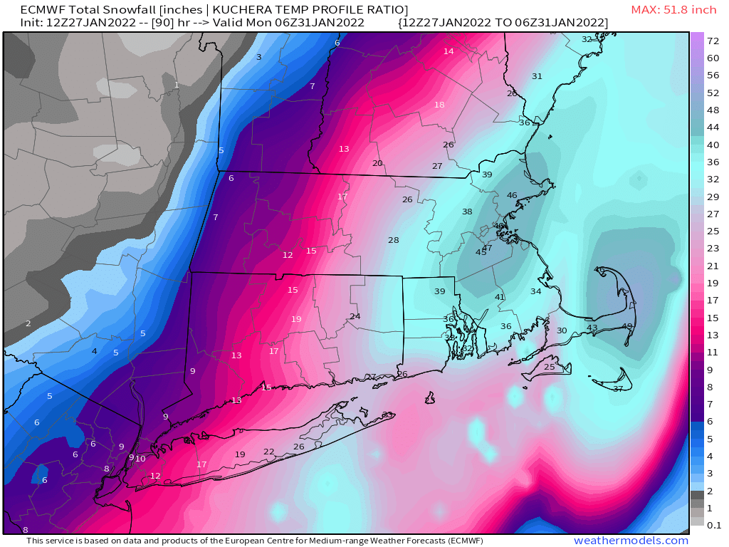
This is just for fun... obviously these are excessive, but even so not often we see this depiction...

-
This was among the best Euro runs we've had... Haven't seen the "B" word used in any Box AFDs yet... that should change today
-
To be precise... SLP is actually west of 0z... 966-67 crawling parallel to elbow, ~20-30 miles west of 12z 973-974
-
Definitely better than 6z Ray... any bleeding has stopped
-
thru 42h this looks to land somewhere between 6z and 0z runs
-
thru 30h southern energy better, trough axis a bit better... vs. TPV a tic more stout... we'll see how that balances...
-
Thru h18... differences mostly within noise... southern and northern streams slightly better than 6z, PV a hair more stout... but all very slight
-
Box map updated tonight These amounts will likely be expanded and increased Thursday if there is no support for the GFS
-
Yeah I was thinking this was going to be a Cape scraper from early signs In any case, a solid rejection of the far east GFS, along with the big UK/GGEM jumps Despite the confluence, Euro takes a more northeasterly track once it's captured... spreads the goods better up ME coast Good track for a deform band interior eastern MA

-
Thankfully got rid of that dual low nonsense it had earlier
-
thru 36h, perhaps the biggest improvement is in the TPV more restrained glad to see that, that was a more recent fly in the ointment
-
Yeah this should come west And agree, 18z Euro was already pretty west
-
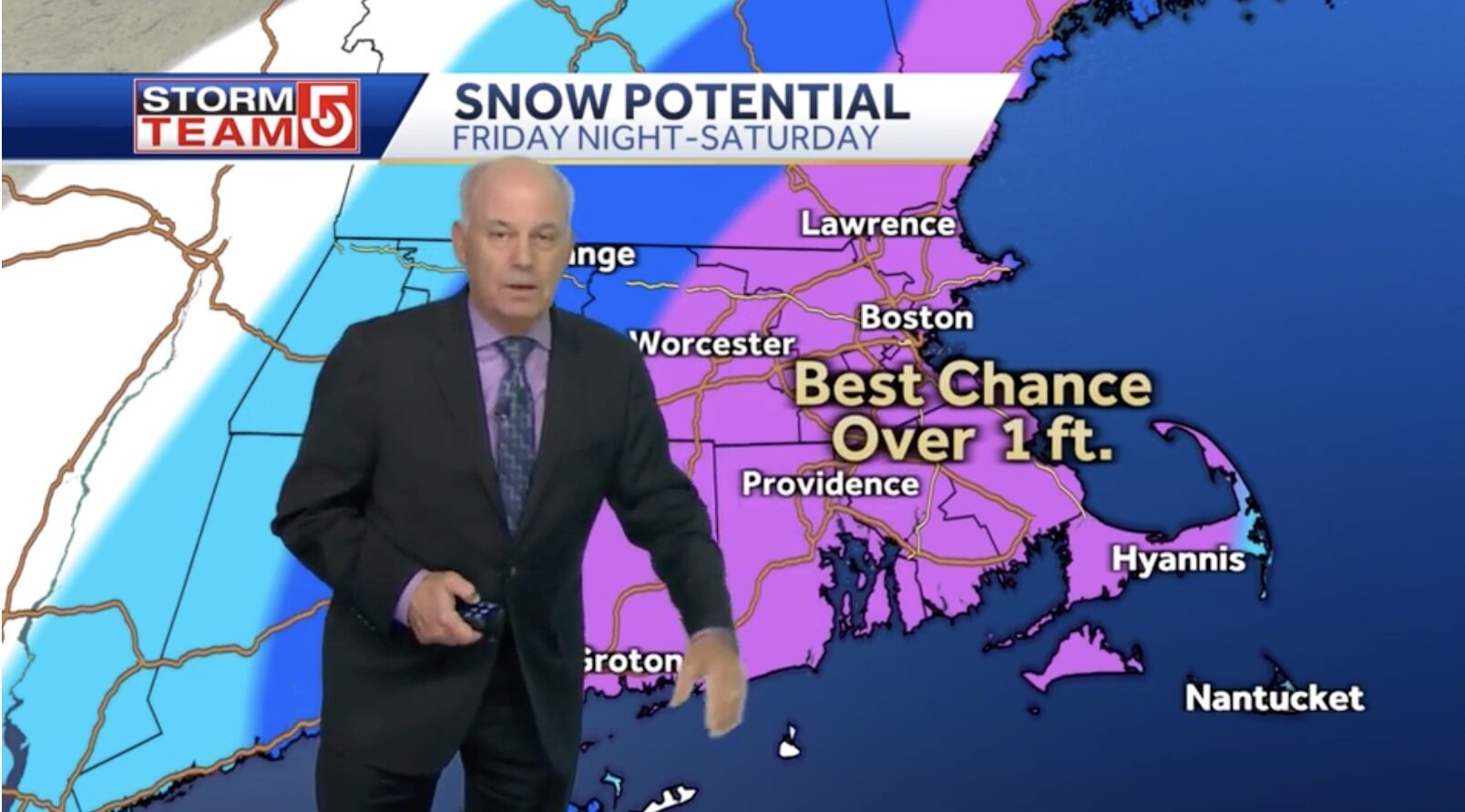
Harv for the fans... 1 foot pushed past Worcester 1 foot+, "potentially much above" in eastern MA