

wxsniss
-
Posts
5,452 -
Joined
-
Last visited
Content Type
Profiles
Blogs
Forums
American Weather
Media Demo
Store
Gallery
Posts posted by wxsniss
-
-
Harv ticked colder for central MA... this map looks very reasonable and anticipates some north ticks... but if there's more support for 12zEuro/18zRGEM, I imagine he'd expand the 8-12 even further south:

-
 2
2
-
-
Ignoring NAM, strong guidance support for this... they ticked higher totals further south... love how relatively uniform this is across much of the SNE forum:

-
1
-
-
Just now, dryslot said:
I don't know if i would label that a big jump, It looked like a couple tics south.
Agree
A tick south and still synoptically has that vort max further north than other guidance.
Not yet the cave that other guidance supports.
-
4 minutes ago, wxsniss said:
18z NAM big jump south... no surprise
As the anomaly in this setup, it was useless
Not as big a jump as expected from confluence, but a definite trend south
Still on the much warmer end of the spectrum
Good hit for SNH
-
18z NAM big jump south... no surprise
As the anomaly in this setup, it was useless
-
1
-
-
12z Euro crushes pike region
Even colder than 0z, let alone 6z
Fair to say NAM warm runs are the anomaly
-
12z UK more or less held, maybe a hair warmer in southern zones / within noise, but it was on the colder extreme at 0z
-
12z GFS ticking colder
-
0z Euro steady, maybe ~10 miles tic north compared to 12z Euro, within noise
Pretty remarkable consensus and consistency for ~2.5 days away... unusual for this otherwise wacky season
-
1
-
 1
1
-
-
56 minutes ago, weathafella said:
Yes. I hope Kevin is sleeping
Harv was pretty bullish earlier... sleet maybe at most to pike, otherwise mostly snow, 8" line through Boston

-
3
-
-
11 minutes ago, dendrite said:
A lot more confluence this run. I'll be shocked if the NAM doesn't come south.
Yeah NAM definitely coming south a good chunk
You could say it's NAM caving given that it was alone and northernmost, but NAM still not in dependable range anyway
-
1
-
-
7 minutes ago, CoastalWx said:
Man that map and the placement of the cities and those range values. Woof.
Not one of our higher-stakes nail-biting KU's, but kind of nice to have a relatively stress-free leadup for a change.
And (I added above): eastern zones may see an addition 1-2" after 7pm
Also as Tip just posted: arguably worse impact of IP/ZR and freezeover in southern zones
-
3
-
-
Opening bid from NWS... pretty strong guidance support for this
Eastern zones may pick up an additional 1-2" on top of this 7-7pm map
Nice widespread event, it's been a while...

-
3
-
 1
1
-
-
Impressive 2 minutes... rivals rates we saw during that WAA ~1:30am Dec 17, 2020
Looks like it dissipated a bit once inside 495
Love seeing streetlights turn on from preceding darkness
-
 Warning up between 495 and 95
-
6 minutes ago, CoastalWx said:
BOX go out for happy hour?
Was wondering same, but just saw this AFD update:
340pm update... still doing "nowcasting" of the band of snow showers. It does appear it is weakening as it`s now getting into the CT River Valley, but that could be an artifact of radar coverage since our radar beams are highest above the ground in that part of the area - so we don`t have good sampling of the lowest few thousand feet where all the action is. Still locally brief heavy snow producing low visibilities for a few minutes and that is expected to be the case for the next hour or so as it moves east. Latest HRRR still shows the band stays together at it reaches the coast, so we can`t totally write it off at this point. Just might not be strong enough to warrant Snow Squall Warnings, but still will produce some briefly difficult driving conditions. -
Sun is out through cloud breaks in Boston area, let's see if we can maintain/boost instability as the band progresses east
-
On hires models, echoes appear to intensify significantly as soon as band moves off coast… why is that? Steeper lapse rates?
-
1
-
-
-
A decent tic up
700 fronto is delivering at the moment

-
1
-
-
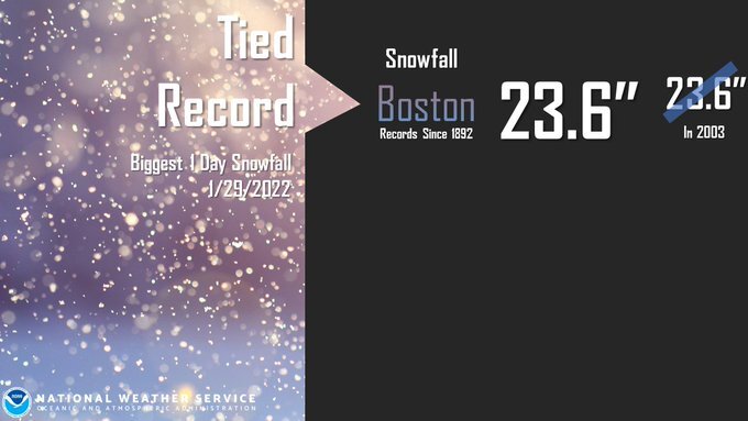
KBOS final 23.8 (0.2 fell Friday)
-
3
-
 1
1
-
-
That Worcester now 495 band is fascinating... keeps regenerating while pivoting east, and can also see additional pulses entering from northeast... deformation? pieces of CCB? some low-level convergence?
the smaller band behind it further west is reinvigorating too
-
2
-
-
1 hour ago, weathafella said:
HRRR and RAP did ok.
RAP better than HRRR
Also I forgot: in shortterm HREF was decent

-
1
-
-
Awesome storm
The Memento tattoos (add any thoughts, correct if wrong): trust nothing more than Euro and within-24hr-NAM. RGEM was terrible.
I thought winds were somewhat underwhelming, peak seemed around 18z... perhaps reflecting the extreme tilt of the system with the surface low so far east. And that peak deepening was in morning hours. Nowhere close to Jan 2005 for Boston area which was virtually a white hurricane, dynamics unmatched since imo.
-
1
-
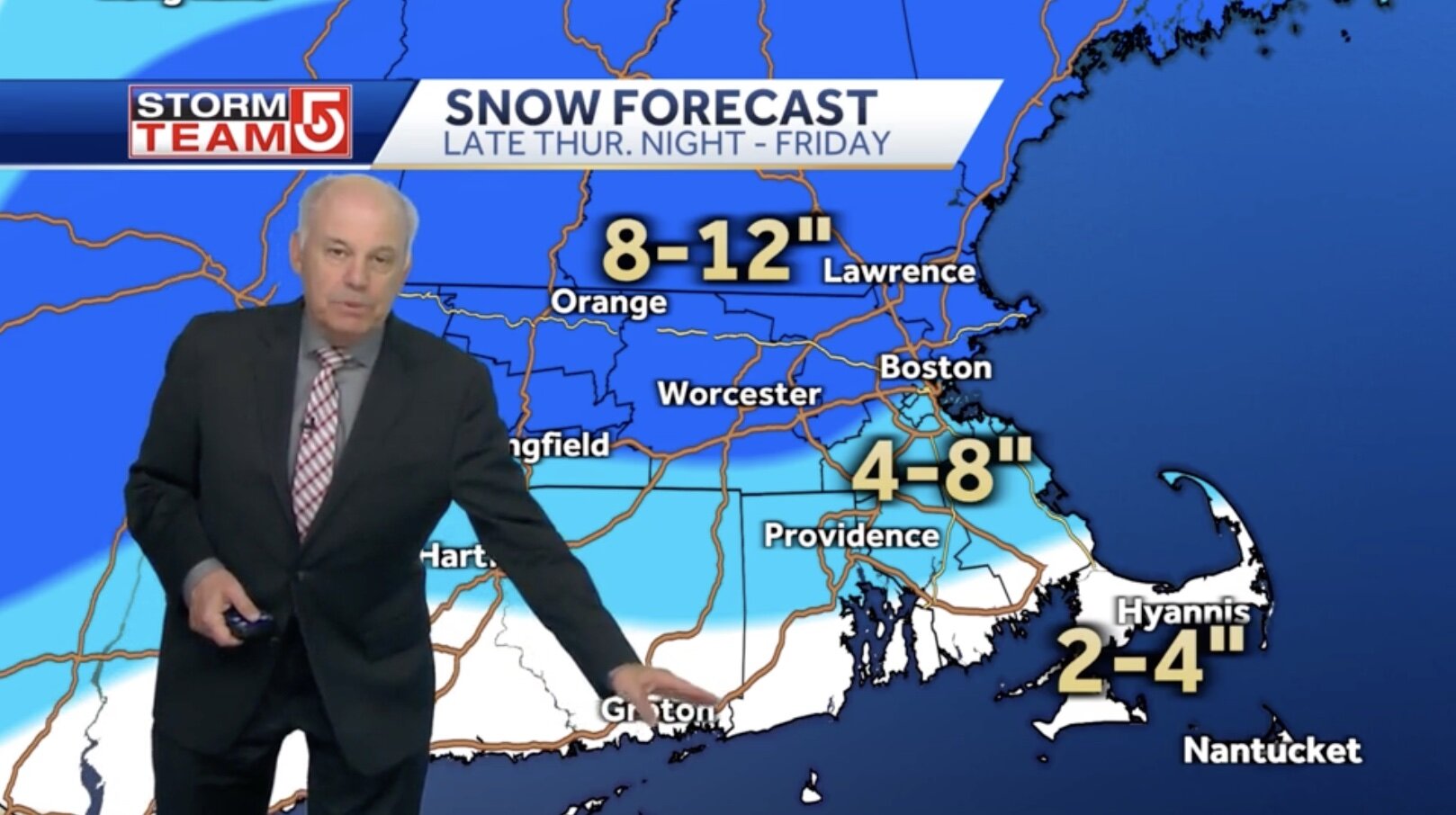


Winter storm for the 25th of February is imminent.
in New England
Posted
Much better run for SCT/SEMA folks
Has been nearly identical for pike region for 5+ runs now
Also has been consistent with a closing 1-2" 21z-3z