MoWeatherguy
-
Posts
2,298 -
Joined
-
Last visited
Content Type
Profiles
Blogs
Forums
American Weather
Media Demo
Store
Gallery
Everything posted by MoWeatherguy
-
MO/KS/AR/OK 2020-2021 "Winter" Discussion
MoWeatherguy replied to JoMo's topic in Central/Western States
Yes I wonder as well. Long- range forecasting still has a ways to go for sure. -
MO/KS/AR/OK 2020-2021 "Winter" Discussion
MoWeatherguy replied to JoMo's topic in Central/Western States
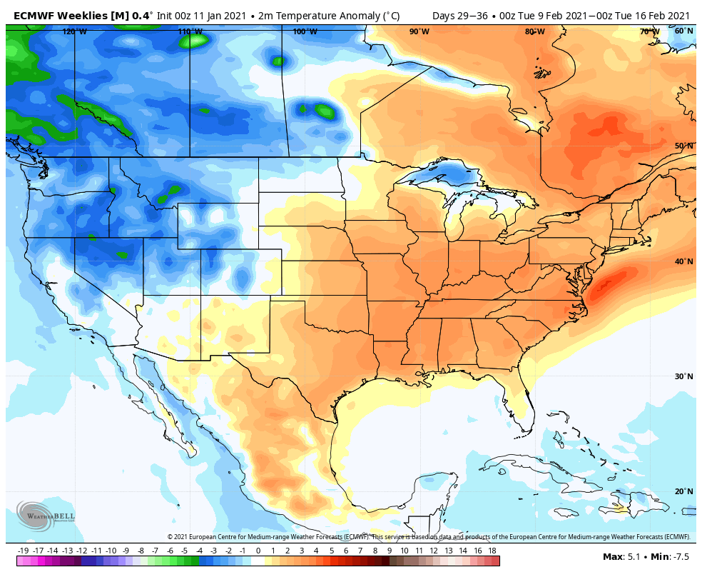
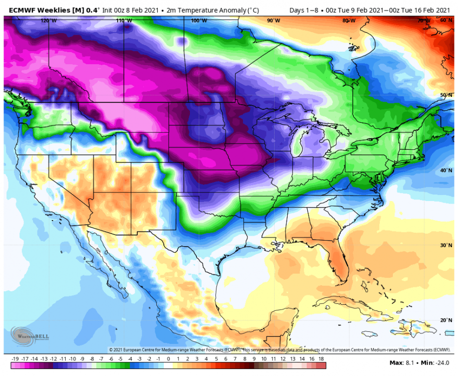
How have the Euro weeklies been this year u ask? Well, here you go. Top pic is the current weeks forecast from a month ago. Next pic is the newest forecast, same time period.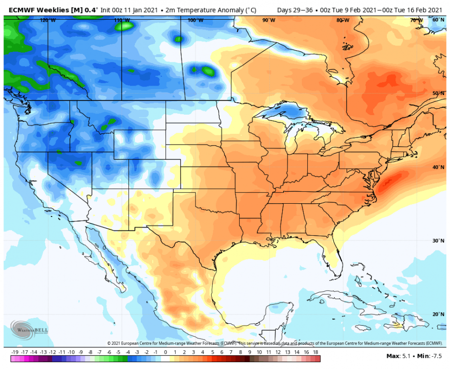
-
MO/KS/AR/OK 2020-2021 "Winter" Discussion
MoWeatherguy replied to JoMo's topic in Central/Western States
Still 35 here in Bella Vista. And that's close to the MO state line. -
MO/KS/AR/OK 2020-2021 "Winter" Discussion
MoWeatherguy replied to JoMo's topic in Central/Western States
Agree. The GFS appears overdone on temps and will prolly modify as we get deeper into this. -
MO/KS/AR/OK 2020-2021 "Winter" Discussion
MoWeatherguy replied to JoMo's topic in Central/Western States
12z GEM looking a lot like the 0z Euro with temps now. GFS and Icon are by themselves. GFS has been consistent tho -
MO/KS/AR/OK 2020-2021 "Winter" Discussion
MoWeatherguy replied to JoMo's topic in Central/Western States
I read from another blog the Euro lost around 7000 data reporting stations due to the pandemic. Been very erratic in the long range. -
MO/KS/AR/OK 2020-2021 "Winter" Discussion
MoWeatherguy replied to JoMo's topic in Central/Western States
Pretty rough for February standards for sure. I'm not a fan of these overpowering arctic fronts. We'll be lucky to get a big storm out of it. -
MO/KS/AR/OK 2020-2021 "Winter" Discussion
MoWeatherguy replied to JoMo's topic in Central/Western States
Gotta think there would be something with a strong wave like that. -
MO/KS/AR/OK 2020-2021 "Winter" Discussion
MoWeatherguy replied to JoMo's topic in Central/Western States
All eyes on early next week now. -
MO/KS/AR/OK 2020-2021 "Winter" Discussion
MoWeatherguy replied to JoMo's topic in Central/Western States
Bout damn time. Hopefully not another false alarm. Maybe this is gonna be a bookend winter. -
MO/KS/AR/OK 2020-2021 "Winter" Discussion
MoWeatherguy replied to JoMo's topic in Central/Western States
Didn't see that. Must be a late add. Lol just another dusting, eh. -
MO/KS/AR/OK 2020-2021 "Winter" Discussion
MoWeatherguy replied to JoMo's topic in Central/Western States
Nothing like 10 ft of snow in the Sierra Detailed forecast for West Slope Northern Sierra Nevada Tonight Snow showers. Windy. Lows 11 to 26 higher elevations... 25 to 31 lower elevations. Snow accumulation of 11 to 17 inches. Prevailing south winds 15 to 30 mph. Gusts up to 40 mph increasing to 55 mph after midnight. Wednesday Heavy snow showers. Windy. Highs 22 to 36. Snow accumulation of 8 to 14 inches lower elevations...except 22 to 28 inches higher elevations. Prevailing south winds 25 to 35 mph with gusts to around 60 mph decreasing to 15 to 25 mph with gusts to around 45 mph in the afternoon. Wednesday Night Heavy snow showers and heavy rain showers. Breezy. Lows 18 to 33 higher elevations...around 33 lower elevations. Snow accumulation of 4 to 10 inches lower elevations...except 24 to 30 inches higher elevations. Snow level 4500 feet. Prevailing south winds 10 to 25 mph with gusts to around 40 mph. Thursday Heavy snow showers and heavy rain showers. Not as cold. Highs 25 to 40 higher elevations...35 to 43 lower elevations. Snow accumulation 2 to 4 inches lower elevations... Except 17 to 23 inches higher elevations. Snow level 4500 feet. Prevailing south winds 10 to 20 mph with gusts to around 35 mph. Thursday Night Rain and snow showers. Lows 16 to 31 higher elevations...29 to 37 lower elevations. Snow accumulation up to 1 inch lower elevations...except 7 to 13 inches higher elevations. Snow level 4500 feet. Prevailing south winds 5 to 15 mph. Friday -
MO/KS/AR/OK 2020-2021 "Winter" Discussion
MoWeatherguy replied to JoMo's topic in Central/Western States
GFS says there could be a bit of snow around here on Wednesday. Just looking at thickness and 850's. -
MO/KS/AR/OK 2020-2021 "Winter" Discussion
MoWeatherguy replied to JoMo's topic in Central/Western States
Where's old man winter? Anything good on the horizon? People keep talking end of Jan, now Feb. Not a good sign IMO. -
MO/KS/AR/OK 2020-2021 "Winter" Discussion
MoWeatherguy replied to JoMo's topic in Central/Western States
Same here. -
MO/KS/AR/OK 2020-2021 "Winter" Discussion
MoWeatherguy replied to JoMo's topic in Central/Western States
https://groups.google.com/g/weatheramerica/c/65Pduff_GOI I always like reading posts from Larry Cosgrove, in case you're interested. He's on board for a cold, stormy last 2 weeks of Jan. -
MO/KS/AR/OK 2020-2021 "Winter" Discussion
MoWeatherguy replied to JoMo's topic in Central/Western States
Good read. -
MO/KS/AR/OK 2020-2021 "Winter" Discussion
MoWeatherguy replied to JoMo's topic in Central/Western States
Proof that we can cash in here without the aid of true arctic air. -
MO/KS/AR/OK 2020-2021 "Winter" Discussion
MoWeatherguy replied to JoMo's topic in Central/Western States
Yes. Huge flakes here for awhile now. -
MO/KS/AR/OK 2020-2021 "Winter" Discussion
MoWeatherguy replied to JoMo's topic in Central/Western States
Nice flakes now in Bella Vista. -
MO/KS/AR/OK 2020-2021 "Winter" Discussion
MoWeatherguy replied to JoMo's topic in Central/Western States
Without a doubt. Where did that come from lol. -
MO/KS/AR/OK 2020-2021 "Winter" Discussion
MoWeatherguy replied to JoMo's topic in Central/Western States
The pattern is definitely favorable this year -
MO/KS/AR/OK 2020-2021 "Winter" Discussion
MoWeatherguy replied to JoMo's topic in Central/Western States
My gut is a lot of these systems this winter will be more south. Been the trend for awhile now. Could be our yr. -
MO/KS/AR/OK 2020-2021 "Winter" Discussion
MoWeatherguy replied to JoMo's topic in Central/Western States
I hear ya. This has been an unusual stretch of bad luck. I've heard Dan Skoff call it the Fayetteville fizzle. -
MO/KS/AR/OK 2020-2021 "Winter" Discussion
MoWeatherguy replied to JoMo's topic in Central/Western States
Yah finally got a good one here. Looks like the Fayetteville fizzle hurt your totals again this time.