
SLPressure
-
Posts
558 -
Joined
-
Last visited
About SLPressure

Recent Profile Visitors
2,380 profile views


-
Thank you!
-
I have to lead an outdoor program this evening in the Mt. Vernon are of Fairfax county. With the waffling of the precipitation potential, what are thoughts on odds of steady, moderate, rain between 6 and 9 pm?
-
I know we used to have a storm mode sometime in the past. Wasn't there also a model mode? No banter during the running of the models, or something to that effect. Parsing through 10 pages to find real information is getting old.
-
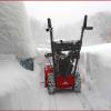
6.8" National Harbor
-
Yeah, can't always go with the verbatim translation of any model output. Or with the current temperature. Or with anything to do with the weather. It will definitely humble anyone. But I am loving that I was wrong!
-
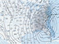
DCA still at 34. Modeled at 29. Doesn't bode well for the temperature forecast today. NAM 3k 10:1 4-8, Positive snow depth change 2-3.
-
On TT, there is the option to look at "positive snow depth change". What exactly does that mean? It shows 7 north to 8 south at 45h, yet 10-1 has 8 north to 12 south. Which is more accurate?
-
I know it has been previous mentioned, snowing for 24 hours and the hourly rate is relatively light. How will daytime temperatures above 32 degrees affect the accumulation as depicted on the modeled maps?
-
Ugly for us south and east of DC. Ugh.
-
NFL model forum. Awesome!
-
January Medium/Long Range: A snowy January ahead?
SLPressure replied to mappy's topic in Mid Atlantic
LOL. I took the bait. My bad. -
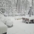
SN+ at the moment. Covering everything all over again. Awesomely beautiful!
-
Just started snowing again in National Harbor. 6" on the ground so far.
-
Thank you!
-
Oof?


